
Creek War, Battles and Forts
- Profile
- Images
Location: Alabama, Mississippi Territory


Service started:
Unit(s):
Service ended:
“If the Lord’s willing and the Creeks don’t rise,” refers to the Creek Indians.
These Creek War Space Pages were written by Allan Harl Thomas

|
| Benjamin Hawkins and the Creek Indians, 1805 |
Creek Civil War 1811 - 1814
The Creek Civil War became entwined with the British and American forces toward the end of the War of 1812. This leads to several questions that need to be answered to comprehend the events that transpired causing these two Wars to converge.
- I. What European disputes were occurring in the Southern U.S. during this time?
- II. What catalyst created two opposing factions in the Creek Nation?
- III. What were other important catalysts that were occurring during this time?
- IV. Final outcome of the Creek War and War of 1812.
I. European disputes occurring in Southern U.S.
Spain was the first European country to claim the entire Gulf Coast from the Florida Keys to the Mississippi River during early exploration of the Southeastern U.S. On the Atlantic Coast, Spain claimed as far north as present day Port Royal, South Carolina. By the 1500's, Spain had already built and manned harbors in Mobile, Alabama and Pensacola, Florida. In 1564, French Huguenot settlers had arrived on the Florida coast and constructed Fort Caroline on the east side of St. Johns River. In order to hold her control over Florida, Spain destroyed Fort Caroline in 1565.
By the time New Orleans was founded in 1718, the city had become a "melting pot" of the French and Spanish cultures, an important harbor, as well as a large commercial center for both countries and the U.S. No one wanted to jeopardize losing their influence on this prime territory, thus New Orleans became a pawn as can be seen by the 1762 Treaty of Fontainebleau that concealed the transfer of New Orleans from France to Spain and later returned to France in 1800 through the Third Treaty of San Ildefonso.
In 1783 after several battles, Spain forced Britain to relinquish its West Florida territory and demanded Britain to abandon Pensacola, their Florida Capital. The ongoing clash between these two countries gave Britain the hope of someday reclaiming her Florida territory and Pensacola. They tried in the War of 1812.
Now add the May 1803 Louisiana Purchase by the United States from Napoleon, ( Napoleon needed to fund his war with Britain) and the confusion regarding the boundaries of this purchase in regards to New Orleans. The Louisiana Purchase included Coastal territory from the Mississippi River (and maybe as far as New Orleans) eastward to the Perdido River (historically known as Rio Perdido) which shapes the Alabama, Florida borders.
II. Catalysts Contributing to Opposing factions in the Creek Nation.
The Creek Confederation was the largest tribal group living in the Southeastern U.S. consisting of the Cherokee, Chickasaw, Choctaw, Apalachee, Coweta, Hitchiti, Alabama, Tukabahchee, Natchez, and each of these tribes many branches. The Confederation's strongest common bond was the Muskhogean language with its many divergent dialects. In 1796 Benjamin Hawkins, General Superintendent of Indian Affairs for President George Washington, pushed efforts to "civilize the indigenous peoples" inhabiting the Southern frontier. This effort would make it obvious that two incompatible cultures were developing in the Creek Confederation.
- A. The "emerging" progressive faction - William McIntosh (1775 ? - 1825), leader of the Coweta Creek, believed in centralizing Creek leadership in a National Council similar to the Iroquois Confederation in the Northern U.S. McIntosh could see the advantages the Creek Nation could achieve by becoming farmers, traders, craftsmen and landowners. As landowners, the Creeks could have legal claim to their own lands. As farmers, traders, and craftsmen, the Confederation could become an economic power by learning the skills of Capitalism.
- B. "The Traditional Creeks" preferred to live as they had before the white settlers arrived. To this group of Creeks, traditions were what bound them together. Their traditions centered around Social and Ceremonial life, but just as important were their open lands with no boundaries, which allowed for trapping, hunting, and fishing to support their families. Tecumseh (b. about 1768 - 1813) , Chief of the Shawnee, attempted to block and hopefully stop the encroachment of white settlers by joining forces with Britain in the War of 1812.
- C. Federal Road- The expansion of a narrow post trail used by native Americans and traders into a wagon road (AKA Federal Road) resulted in a higher volume of traffic from the Northeastern and Southeastern states. The new Federal Road would require supply stations, forts, trading posts, and manpower (settlers) to maintain the communities that would soon grow. More importantly the road would encroach on Creek Territory and their hunting grounds.
- D. The Deepening Chasm between the two Creek Ideologies ( traditional vs. progressive) became more eroded by over a century of trade agreements, broken treaties and intermarriage with white settlers
IV. Final Outcome of the Creek War and The War of 1812
- Treaty of Fort Jackson, August 1814, forced the Creeks to cede most of their lands and dramatically alter their way of life. This lead to the removal of most of the native American population and the Trail of Tears in 1831.
- Andrew Jackson became the 7th President of the U.S. (1829-1837).
- The balance of power in Washington moved from the urban commercial powers in the north, to the small businessmen and farmers of the west, east, and south.
- William McIntosh was killed by Upper Creeks following the 1825 Treaty moving the Creeks to the Indian Territories of Oklahoma.
- With the Louisiana Purchase came America’s belief in the Manifest Destiny which provided the drive to continue the westward push.
Influential Leaders
William McIntosh, a leader of the Creek settlement of Coweta, and a Creek Chief of Scottish descent, thought that by centralizing Creek leadership on a national council he could maintain Creek autonomy in the face of aggressive U.S. expansion. (and make a fortune for himself)
Tecumseh, on his visit south, found a society ripe for revolution. His address at the annual Creek Council at Tuckaubatchee in 1811 implored the "Red Stick" faction to regain their dignity by expelling the intruders "upon a trail of blood". He promised the support of the British to establish an Indian Nation.
A Creek warrior called Little Warrior was influenced by Tecumseh’s demands for militant anti-American action. He felt leaders like McIntosh were building their own fortunes at the expense of the Creek Nation. Little Warrior, on his way south from the northern hunting grounds, attacked and slaughtered settlers on the Duck River at the head of the Natchez Trace in Tennessee. Tennessee demanded retribution. Creek Council leaders, who were Creek Chiefs of Scottish descent, debated what to do with Little Warrior and others who carried the "red sticks"—symbolic of brotherhood with Tecumseh. The Creek Council decided to execute Little Warrior. Little Warrior’s execution was, yet, another catalyst of the Creek Civil War.[1]
William Weatherford (Chief Red Eagle, also known as Lamochattee) leader of the Upper Creek and the "Red Stick" faction began diplomatic talks with Spanish and British colonial officials to develop allies against the United States. The British encouraged the Creek resistance. Chief Red Eagle joined the Red Sticks along the frontier with Peter McQueen and other Red Sticks and attacked Fort Mims.
The new capitalist faction of Creek leaders requested help from the American army. Andrew Jackson led his army into Creek country, ending Red Stick military resistance at the March 1814 Battle of Horseshoe Bend where McIntosh was made a brigadier general. This was a request the capitalist Creek leaders would soon regret, when at the Treaty of Fort Jackson they were forced to cede 23 million acres to the U.S.
Andrew Jackson, at the time, a slave trader and land speculator, of the West Tennessee Militia became a military hero as a consequence of his campaigns fought in Alabama ending in the Battle of New Orleans January 08, 1815
Major Confrontations

|
| SamDale. |
September, 1811
Tecumseh delivers address at Tuckaubatchee, site of annual meeting of Creek council. [2]
1812
During the War of 1812, Sir Edward Nicolls was posted to Spanish Florida as part of an attempt to recruit the Seminoles as allies against the United States. In his service, he was shot through the body and right arm, was cut by a sabre cut in the head, bayoneted in the chest, and had lost the sight of an eye.[3][4] [5]
July 27, 1813Battle of Burnt Corn Creek
- Samuel Dale (1772-1841)
- Col James Caller (1758 - 1819)
- Peter McQueen (c. 1780 – 1820)
August 30, 1813Fort Mims Massacre
- Major Daniel Beasley (____-1813) Mississippi Volunteers
- Dixon Bailey
- William Weatherford, also known as Lamochattee (Red Eagle) (c. 1780 or 1781 – March 24, 1824),
November 3, 1813: Battle of Tallushatchee
- General Andrew Jackson
- Brigadier General John Coffee
- federal soldiers

|
| Battle of Talladega. |
November 9, 1813: Battle of Talladega
- General Andrew Jackson
- Brigadier General John Coffee
November 12, 1813: The Canoe Fight
- Samuel Dale (1772-1841)
- Jeremiah Austill (1793- 1881)
- James Smith
- Caesar
November 18, 1813: Hillabee Massacre
- General William Cocke

|
| William McIntosh (ca. 1775-1825). |
November 29, 1813: Battle of Autosse
- General John Floyd
- William McIntosh (ca. 1775-1825)
- Abraham Mordecai (1755-1850)
- Prophet Paddy Walsh
December 23, 1813:Battle of Holy Ground (Econochaca)
- General Ferdinand Claiborne
- Colonel Gilbert Russell, Third U.S. Infantry
- Colonel Joseph Carson, 6th regiment, Militia of Washington County (need profile)
- Pushmataha's Choctaw Troops
January 22, 1814: Battle of Emuckfau Creek
- General Andrew Jackson
- Brigadier General John Coffee
- federal soldiers
January 24, 1814 Battle of Enitachopco

|
| Battle of the Horseshoe Bend. |
- General Andrew Jackson
- Brigadier General John Coffee
- federal soldiers
January 27, 1814: Battle of Calabee Creek
- General John Floyd
- William McIntosh (ca. 1775-1825)
- Abraham Mordecai (1755-1850)
- Major Timpoochee Barnard
- Prophet Paddy Walsh
March 27, 1814: Battle of Horseshoe Bend
- General Andrew Jackson
- Brigadier General John Coffee
- federal soldiers
- Chief Menawa

|
| Red Stick Warrior. |
August 9, 1814:Battle of Stonington
August 9, 1814: Treaty of Fort Jackson
The treaty of Fort Jackson finalized; 23 million acres of Creek territory ceded to the United States, opening up half of the present state of Alabama to white settlement
August, 1814 Jackson moves his headquarters to Mobile to prepare for British attack
Treaty of Ghent Signed December 24, 1814 officially ended the War of 1812.
January 1, 1815 British artillery attack on American forces defending New Orleans
January 08, 1815 Battle of New Orleans (fought after war had ended)
January 10, 1815 British begin bombardment of Fort St. Philip
February 11, 1815 British capture Fort Bowyer
June, 1815 British abandon Apalachicola

|
| Creek War discharge papers for Samuel Beard |

|
| War of 1812 Mississippi Territory Image 2 |
Forts and Stockades
Forts or Stockades established along the Georgia frontier.
Fort Hawkins
Fort Hawkins was built by the United States in 1806 and through 1824, it was a place of "relatively great economic, military, and political importance." For the Creek Nation, it was a center of the deerskin trade with European Americans, who had a trading post and processing factory there, but for them it was most important as related to their sacred grounds at Ocmulgee Old Fields. This continued to be a significant social and ceremonial center until the Removal Act .[6]The city of Macon GA. is the present location of Fort Hawkins.
Fort Mitchell
Established by Gen. John Floyd just across the Chattahoochee River in present-day Alabama.The first Fort Mitchell, built in 1813 as an outpost during the Creek War and War of 1812 and represents the military aspect of Manifest Destiny. It was named for David Brydie Mitchell, a governor of Georgia. The | Chattahoochee Indian Heritage Center has a ceremonial flame memorial to the Creek nation here at the Fort Mitchell Historic Site
Fort Hull
Fort Hull was constructed in January of 1814 to serve as a supply base for General John Floyd’s army. Colonel Homer V. Milton assumed command of the post once Floyd retreated back to Georgia following the Battle of Calabee Creek. The fort site is currently unmarked, and located on private property off County Road 45 in central Macon County, Alabama
Forts or Stockades established along the Mobile, Tensaw, Alabama and Tombigbee Rivers.
In October, 1813, General Thomas Flourney organized a force of about 1,000—consisting of the Third United States Infantry, militia, volunteers, and Choctaw Indians at Fort Stoddert.
Other forts were reinforced with forces under General Ferdinand L. Claiborne of the Mississippi Territory Militia. They were generally sixty yards square. A trench three feet in depth was dug around the outside and bodies of pine trees cut about fifteen feet in length were placed perpendicularly in the trench side by side, making thus a wall of pine wood twelve feet in height. Port holes were cut at convenient distances so as to enable the inmates to look out, and in case of an attack to fire upon the besiegers. In about the same way all these stockades of 1813 were constructed. They were lighted at night by means of the abundant pitch pine placed upon scaffolds, covered with earth, erected for the purpose.

|
| Fort Mims. |
Fort Claiborne,
Fort Claiborne was established by General Ferdinand L. Claiborne. Situated near the Federal Road, During the Creek War a large stockade fort was built. He used the fort as a base for the invasion of the Creek nation with the Regular Army of the United States, the Lower Tombigbee Militia, and friendly Choctaw.
Fort St. Stephens
Fort St. Stephens established by the French, probably about 1714, held afterwards by the Spanish, who made a there settlement about 1786, given up by the Spaniards to the Americans in 1799. So far as the Creek Indians were concerned, this was considered an impregnable fortress. The old St. Stephens was on the west bank of the Tombigbee, on a high bluff, at the head of sloop navigation. Land grants for the Mississippi Territory were issued here.
Fort Stoddert
Fort Stoddert, named Fort Stoddert after Benjamin Stoddert, Secretary of the Navy (1798-1801), was established by United States troops in July, 1799 with stockade and bastion. As this was for some years a government post, held by United States troops, and became a port of entry where the Court of Admiralty was held, it was a strong point of defense. In 1804 Captain Schuyler of New York was commander here, with eighty men, Edmund P. Gaines was Lieutenant, and Lieutenant Reuben Chamberlain was paymaster. At Fort Stoddert duties were exacted on imports and exports.* Four miles west of Fort Stoddert was Mount Vernon. (also known as Fort Stoddart and Fort Stoddard)
Mount Vernon Cantonment
Mount Vernon Cantonment In 1811, the U.S. government built the Mount Vernon Cantonment (a military encampment) three miles inland because yellow fever had broken out too often at the Fort Stoddert.[7]
Fort Charlotte
Fort Charlotte (also known as Fort Conde') Fort Conde was a classic 18th century brick and mortar square fort with large bastions on each corner, gunnery parapet, surrounding moat and outer earthworks. Built in the early 1700's by Bienville, the French founder of Mobile. When the English captured the fort in 1763, the name was changed to Fort Charlotte in honor of George III's Queen. In 1780 the Spanish took possession. Located on the west bank of the Mobile River, Mobile County, Alabama, in the city of Mobile, Alabama
Fort Bowyer
Fort Bowyer In the year 1813, on order of President James Madison, Mobile Point from Spain by U.S. Regulars, under Gen. James Wilkinson, and militia, under Col. John Bowyer. A wood and earth stockade was quickly built here. It was in the shape of a D and armed with cannon taken from Fort Charlotte in Mobile. It’s mission was to protect the entrance to Mobile Bay from the Gulf of Mexico. Located on the east side of the entrance to Mobile Bay, Mobile Point, Baldwin County Alabama, 30 miles south of Mobile, Alabama.

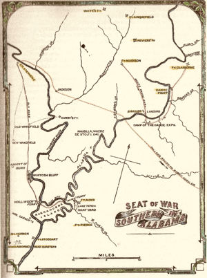
|
| Southern Alabama. |
Tensaw Boat Yard
Fort Mims
This stockade was built in the summer of 1813. When the erection of this stockade was commenced is uncertain, perhaps in July, 1813, and, according to Pickett, its last block house was never finished. The other blockhouse on the Southwest corner, with two large gates- one on the west wall and the other on the east wall was stormed and taken by the Creeks on August 30, 1813. It is important to note that many who died her were mixed race, Indian, Anglo and African. Located 35 miles northeast of Mobile, Alabama, in Baldwin County, Alabama, a quarter mile from the east bank of the Tensaw River.
Fort Pierce
Fort Pierce was a small stockade some two miles south-east of Fort Mims. It took its name from two brothers, William Pierce and John Pierce, who came from New England and made their home there in Spanish times. William Pierce was a weaver and John Pierce a teacher.
Fort Glass
Fort Glass, built sometime in July at the home of Zachariah Glass by himself and his neighbors, Nah-hee, called a Tory Creek, an intelligent Indian, employed in the Creek war as a scout, assisting, it is said, in the building. Fort Glass was occupied by the soldiers.
Fort Madison
Fort Madison was in the north-east corner of section one, township six, range three east of the St. Stephen's meridian, on the water-shed line, which was then the eastern boundary of Clarke County. This was the staging and assembly area for General Jackson’s army for the attack on Spanish Pensacola, Florida. It was north of Fort Glass only two hundred and twenty five yards, and the two stockades constituted one locality, being the center of the quite large Fort Madison neighborhood.
Fort Sinquefield
The Creeks attacked this fort but were unable to take it. Ninety feet distant from the stockade ground, in a northwest direction, are some graves. A few yards eastward of the forts location is supposed to be an old burial place, although the graves were not distinct in 1879. Located about ten miles north of Fort Madison, on the western side of Bassett’s Creek, Clark County, Alabama, was about ten miles north of Fort Madison, five miles south-east from the present town of Grove Hill, county seat of Clark County
Fort Easley
Fort Easley was at what is now called Wood's Bluff. This fort was named, as were nearly all others, from a prominent settler in the neighborhood, and the bluff took its name from Major Wood, an officer in the Burnt Corn expedition
- General Claiborne visited this stockade about the last of August (1813), having received a report that it would be attacked by the Indians. It is possible that some of the Creeks started this report to call attention away from the real fort which they planned to attack, Fort Mims.
Turner's Fort
Turner's Fort was some eight miles south and five west, in the west bend of the Tombigbee River, near the residence of Abner Turner. This fort was built of split pine logs doubled and contained two or three block-houses. It was held by the citizens of the neighborhood, thirteen men and some boys forming the garrison that expected to protect the women and children. Two or three miles distant, on the river, was a Choctaw reservation known as Turkey Town, called by the Choctaws "Fakit Chipunta," Little Turkeys. In this stockade were members of the Turner, Thornton, Pace, and other families. Here for a time resided Tandy Walker, who is mentioned in the Gaines records, who was "a most experienced and daring backwoodsman;" but in the summer of 1813 he was connected with the affairs at Fort Madison.
Rankin's Fort
Rankin's Fort quite a large stockade, and the most western one of the River Group. Located in Washington County, Alabama.
McGrew's Fort
McGrew's Fort was in the corner of section one, township seven, range one west, about three miles north of Fort St. Stephens, in Clarke county. Here two brothers, William McGrew and John McGrew, British royalists then, refugees, probably, from the Atlantic coast, made an early settlement near the Tombigbee River. McGrew's Reserve, an old Spanish grant.
Fort Carney
Fort Carney on the line of travel to Mount Vernon. This fort was built by Josiah Carney who settled on the river in 1809.
Forts and Stockades built by Jackson

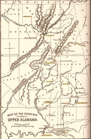
|
| Upper Alabama. |
General Jackson departed Fayetteville, Tennessee on October 7, 1813. When Jackson began his advance, the Tennessee River was low, making it difficult to move supplies, and there was little forage for his horses.
Fort Deposit
Fort Deposit was a fort that was built under the order of General Andrew Jackson. This was a supply fort that was built to serve the soldiers during the Creek Indian War. Located on the Tennessee River at Honey (Thompson's) Creek.
Fort Strother
The fort was built by General Andrew Jackson and several thousand militiamen in November 1813, during the Creek War. It was to serve as his base of operations against the Red Sticks. It was located at Ten Islands in the Mississippi Territory, in what is today St. Clair County, Alabama and was located on a bluff of the Coosa River.
Fort Williams
Fort Williams was a supply depot built in early 1814 in preparation for the Battle of Horseshoe Bend. It was located in Alabama on the southeast shore where Cedar Creek met the Coosa River, near Talladega Springs. The original site was submerged under Lay Lake with the 1914 construction of the Lay Dam 14 miles downstream.
Fort Jackson
Fort Jackson was a wooden Stockade with blockhouse, built on the remains of the French Fort Toulouse (built in 1717) on April 17, 1814. At this site : Red Stick Chief William Weatherford (Red Eagle) surrendered. See Also:Fort Toulouse a category on Wikitree.
Sources
- ↑ http://homepages.rootsweb.ancestry.com/~cmamcrk4/pkt35.html
- ↑ Life and times of Gen. Sam Dale, the Mississippi partisan (1860) Author: Claiborne, J. F. H. (John Francis Hamtramck), 1809-1884, pages 59-61
- ↑ https://www.royalmarineshistory.com/post/general-sir-edward-nicolls-kcb-the-fighting-nicolls
- ↑ https://academic.oup.com/florida-scholarship-online/book/15911/chapter-abstract/170825743?redirectedFrom=fulltext
- ↑ https://en.wikipedia.org/wiki/Edward_Nicolls
- ↑ http://thelamarinstitute.org/images/PDFs/publication_124.pdf
- ↑ http://www.encyclopediaofalabama.org/article/h-3259#sthash.xK4c0tIC.dpuf
- E Book Lossing's The pictorial field-book of the war of 1812; or, Illustrations, by pen and pencil, of the history, biography, scenery, relics, and traditions of the last war for American independence by Lossing, Benson John, 1813-1891
- E Book THE CREEK WAR OF 1813 AND 1814 By H. S. HALBERT and T. H. BALL, Chicago, Illinois: Donohue & Henneberry; Montgomery, Alabama. White, Woodruff & Fowler 1895; and a facsimile reproduction by University of Alabama Press, May 30, 1995.[8]
- E Book Andrew Jackson : the gentle savage by Karsner, David, 1889-1941 Published 1929
Author: Claiborne, J. F. H. (John Francis Hamtramck), 1809-1884
- E Book A view of West Florida, embracing its geography, topography, &c. with an appendix, treating of its antiquities, land titles, and canals, and containing a map, exhibiting a chart of the coast, a plan of Pensacola, and the entrance of the harbor. by John Lee Williams. Published 1827 Library of Congress
- E Book A concise natural history of East and West-Florida– Bernard Romans. "Concise Natural History can be placed firmly in the genre of colonial promotional literature. Romans's book was an enthusiastic guide aimed at those seeking to establish modest holdings in the region:"[9]
- E Book The journal of Andrew EllicottIn 1796, George Washington commissioned Ellicott as the U.S. representative on the commission for the survey of the border between the Spanish territories in Florida and the United States [10]
- E Book The Creek War of 1813 and 1814
- Military Roads in the Florida Parishes of Louisiana Powell A. Casey
- Find A Grave Memorial Stone at Ft. Mims printed in 1895 by Halbert, Henry S. (Henry Sale), 1837-1916
Bibliography
- Atlantic Loyalties: Americans in Spanish West Florida, 1785-1810 Integrating social, cultural, economic, and political history, this is a study of the factors that grounded--or swayed--the loyalties of non-Spaniards living under Spanish rule on the southern frontier.
- Struggle for the Gulf Borderlands, The Creek War and the Battle of New Orleans, 1812-1815 by Frank L. Owsley , Jr
- Federal Road Through Georgia by Henry deLeon Southerland, Jr, Jerry Elijah Brown
- A Conquering Spirit, Fort Mims and the Redstick War of 1813-1814, Written by Gregory A. Waselkov Publication Year: 2006]
- [http://creekwarandwarof1812.com/index.html Battle for the
Southern Frontier]: The Creek War and the War of 1812; July 1, 2008 by Mike Bunn, Clay Williams
- American Colonies, The Settlement of North America by Alan Taylor, pub. Penguin Books, 2001
- The Indians of The Southeastern United States by John R. Swanton, pub. Smithsonian, 1979
- The War of 1812 And the Rise of The U.S. Navy by Mark Collins Jenkins and David A. Taylor, pub. National Geographic, 2012
Acknowledgements
We would like to thank Regina Fortenberry Cross for her comprehensive contributions on the Creek Civil War.


- Login to request to the join the Trusted List so that you can edit and add images.
- Private Messages: Send a private message to the Profile Manager. (Best when privacy is an issue.)
- Public Comments: Login to post. (Best for messages specifically directed to those editing this profile. Limit 20 per day.)
- Public Q&A: These will appear above and in the Genealogist-to-Genealogist (G2G) Forum. (Best for anything directed to the wider genealogy community.)
 Paula J
 Terry Wright
Paula J
Terry Wright
Terry Wright
Paula J
Terry Wright