Public Photo

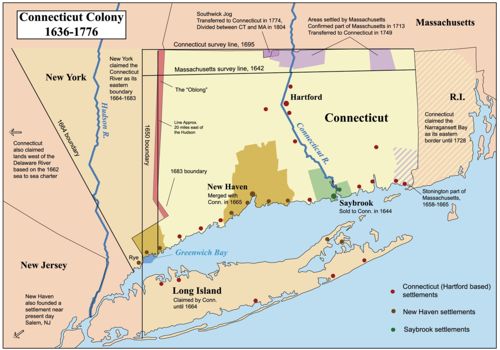
The Colonies That Became Connecticut

In this image:

Where: [location?]

When: [date?]

Uploaded: .

Comments: 2, WikiTree Popularity: 1.

Original digital image: 1428 x 1000 pixels.


Do you love this photo? Maybe it's just interesting, or there's a story behind it? Please share it with the WikiTree community.


This image is open for viewing but you need to be logged in to edit the details. Please login here.
Comments: 2

There are no comments yet.
Login to post a comment.
Attribution: By No machine-readable author provided. Kmusser assumed (based on copyright claims). [CC BY-SA 2.5 (http://creativecommons.org/licenses/by-sa/2.5)], via Wikimedia Commons

This file is licensed under the Creative Commons Attribution-Share Alike 2.5 Generic license.

https://commons.wikimedia.org/wiki/File:Ctcolony.png

posted by Anne B
This is a map showing the Connecticut, New Haven, and Saybrook colonies from 1636-1776. It includes the territorial disputes between Connecticut and its neighbors during that time period. It does not show Connecticut's western land claims and dispute with Pennsylvania. Based primarily on descriptions from The Boundary Disputes of Connecticut by Clarence Winthrop Bowen. James R. Osgood and Company, Boston, 1882.
posted by Anne B