
Harris County, Texas
- Profile
- Images
Location: [unknown]
Surnames/tags: Harris_County us_history Texas
| ... ... ... is a part of Texas history. Join: Texas Project Discuss: Texas |


|
| Harris County, Texas |
| Northwest Waller County |
North Montgomery County |
Northeast Liberty County |
||
| West |
Harris County | East Chambers County |
||
| Southwest Fort Bend County |
South Brazoria County |
Southeast Galveston County |
||
Contents |
History
Archeological sites in what is now present-day Harris County have revealed the presence of human beings as early as early as the Neolithic period (4000 B.C.), including a deposit of human remains and dart points dating from 4000 to 1000 B.C.
A site on Clear Lake features a shell midden and cemetery with early ceramics dating between 1400 B.C. and A.D. 950. Other sites in the western area and along Galveston Bay have yielded pottery, stone tools, and points from 2,000 years ago. Many shell middens along the bayshore and brackish streams were destroyed in the nineteenth century when residents used the convenient shell heaps for construction.[1]
Early Spanish Exploration (1528-1532)
- Álvar Núñez Cabeza de Vaca, an early explorer and the first historian of Texas, departed Spain in June 1527 with five ships and a contract from the Holy Roman Emperor Charles V (Charles I of Spain) which permitted him to settle and colonize the region between present-day Florida and Tampico, Mexico.[2]
- After a serious misfortunes on the journey which led to a party being shipwrecked near present-day Galveston island, Cabeza de Vaca became the first European of record to become a Texas merchant. He carried sea shells and what he called “beads of sea” (probably pearls) into the interior reaches of Texas, where traded for bison skins and red ochre.[3][4]
French Exploration (1684-1689)
- The French explorer, La Salle, during the last phase of his extraordinary career, centred on his proposal to fortify the mouth of the Mississippi and to invade and conquer part of the Spanish province of Mexico. A gross miscalculation brought the ships to Matagorda Bay in Texas, 500 miles west of their intended landfall. After several fruitless journeys in search of his lost Mississippi, traveling as far west as the Rio Grande and as far east as the Trinity River, La Salle met his death at the hands of mutineers near the Brazos River.[5]
Spanish Texas (1690-1821)
- During the early 18th century, French traders began visiting the Galveston Bay area to trade with the Akokisa (Orcoquisa) and Bidai Indians. The French came both by boat from New Orleans and overland from Nacogdoches to exchange European goods for furs, skins, and bear grease.[6][7]
- In 1745, the captain of the presidio at La Bahia, Don Joaquin de Orobio y Bazterra, wrote to the viceroy in Mexico in regards to rumors of French activity at the lower Trinity River. Orobio was ordered to explore the area to determine the French aggression, and determine information on the Indians in the region.[8]
- Don Joaquin de Orobio y Bazterra arrived at a place he called San Raphael (present-day Spring Creek) on March 15, 1746; and on March 23, visited the proposed French site on the Nuestra Senora de Aranzazu (present-day San Jacinto river) and determined the site lacked the natural resources to build and maintain a sizeable settlement.[8]
- From 1747-1753, the governor of Texas, Jacinto de Barrios y Jauregui, devised an illegal trade network in which the Spanish acted as middlemen, exchanging goods between the French and Indians.[8]
- By May of 1754, French trader, Joseph Blancpain, and several other Frenchmen set up a permanent trading post near the east bank of the Trinity River, about 8 kilometers upstream from Trinity Bay [6][7] and by October of 1754, Spanish Lt. Marcos Ruiz was dispatched to the French trading post along with 25 men to arrest the Frenchman. Ruiz was informed by the Orcoquiscas of the area that a French trader, Lacreu, had recently left the camp towards New Orleans in search of 50 families waiting to settle in Texas.[8]
- From 1756 through 1771, determined to prevent a French settlement of the area, the Spanish established the Presidio of San Augustín de Ahumada in the precise location of Blancpain's trading post. Lieutenant Domingo del Rio was appointed commander of the presidio. The Spanish then established the accompanying Mission of Nuestra Señora de la Luz del Orcoquisac for the Akokisa. Calling the site El Orcoquisac, they made plans to turn it into a civil settlement of 50 families, creating a permanent Spanish presence in the Galveston Bay area.[8]
- In 1805, Governor Antonio Cordero sent soldiers to El Orcoquisac to halt illegal activities in the area. Within a few months, having determined El Orcoquisac to be unsuitable for horses and people, a garrison was established in Atascacito (near the present-day Harris County, Liberty County border).[8]
- From 1815 to 1817, expeditions from New Orleans came to aid the Mexican Republic rebel against Spain. Louis Michel Aury, Francisco Xavier Mina, pirate Jean Laffite, and James Long looked around the San Jacinto for possible homesites[8] while 400 French exiles sought refuge in the area of El Orcoquisac. Spanish were again called to the area; however, the French were warned by friendly Indians and escaped to Galveston Island near the pirate Jean Laffite's establishment. In Oct 1818, Spanish troops arrived at the abandoned French fortress near the Trinity and destroyed it.[8]
Mexican Texas (1821–1836)

|
- Beginning in 1822, settlers came to the area thinking that the San Jacinto River was part of Stephen F. Austin's empresario grant. Baron de Bastrop issued 29 grants to settlers (with incomplete surveys). Some settlers moved to the Brazos River, some eventually worked on the river for the transportation system. The Gulf shore and Galveston Island were forbidden to Anglo settlement, present-day Harris County considered the SE border of the colony. The area was known as San Jacinto District.
- In 1824, John Richardson Harris received a grant of land from the Mexican government of 4,425 acres which he located at the junction of Buffalo and Bray's bayous, about twenty miles from Galveston Bay in Stephen F. Austin's colony as a part of Austin's Old Three Hundred. During the summer of 1829, Harris found himself in need of parts for his uncompleted sawmill. He boarded his Schooner, The Rights of Man, and set sail for New Orleans, the center of business at that time on the northern coast of the Mexican Gulf. New Orleans at that time was in the grips of an epidemic of yellow fever. Harris contracted the disease and within five days, on August 21, 1829, died from its effects.[9][10]
- In 1830, travelers crossed San Jacinto River on Lynch's Ferry, traveling to the sites of present-day Anahuac, Liberty or Nacogdoches. A road ran parallel to Buffalo Bayou heading NW to Spring Creek, then forked to head to Brazos villages. Road #3 followed the south bank of Brays Bayou 15 miles toward Oyster Creek to Stafford, Fort Bend County.
- Jane Birdsall Harris, John R. Harris' widow, did not come to Texas until 1833, at which time her eldest son, DeWitt Clinton Harris, had reached an acceptable age to accompany her and the remainder of the family. Jane and DeWitt traveled by stagecoach, canal boat, steamboat, then sailing ship to reach Harrisburg. Upon her arrival, Mrs. Harris began to construct a home for herself and her family, the original home John R. Harris being occupied by his brother, David Harris.
- In August of 1835, Zavala, a refugee from Santa Antonio López de Santa Anna's wrath, bought a house on the north side of Buffalo Bayou below Harrisburg where his 2nd wife of New York and three children joined him in December.[1] Some residents also participated in the Anahuac Disturbances in 1832 and 1835 and the call for volunteers in September 1835 to oppose Gen. Martín Perfecto de Cos.
- Interim President David G. Burnet with Vice President Lorenzo de Zavala of the new Republic of Texas were elected by the delegates at Washington after midnight on March 16, 1836, and the next morning left for Harrisburg, traveling by water in case the Mexican Army might win the Battle of San Jacinto. Refugees from the upper Brazos settlements came across Harrisburg Municipality, fleeing to the United States.[1] On 21 March 1836, the home of Jane Birdsall Harris, located in Harrisburg became the Capital of the Republic of Texas, when David G. Burnet with Lorenzo de Zavala and members of the presidential cabinet met there. [11][12] Brothers John Kirby and Augustus Chapman Allen saw the potential of the Buffalo Bayou and began laying out the town that would later become Houston.[1]
- On Apr 12, 1836, the republic's officials evacuated Harrisburg by steamboat to Lynchburg when they learned Santa Anna with his troops were crossing the Brazos River near Richmond. The steamboat Cayuga later took the officials and their families to Galveston Island.[1] By April 14, 1836, Santa Anna and his advance units reached Harrisburg at midnight and, after a day of looting, set fire to the settlement on the sixteenth; after which Santa Anna almost captured the Burnet family at Morgan's Point.[1] From April 20-21, 1836, the Battle of San Jacinto took place on Peggy McCormick's farm (opposite Zavala's house). There 600 dead soldiers remained unburied when neither commander ordered interment.[1] Legend for the San Jacinto war outcome neglected to mention, that some of the Mexican prisoners chose to remain in Harris County when all were released, by President Sam Houston.[1]
- Harrisburg County was officially formed by the First Congress on December 22, 1836. The lawmakers named Andrew Briscoe chief justice and the infant city of Houston the county seat and national capital of soon to be Republic of Texas.[13][1]
Republic of Texas (1836–1845)
- In March of 1837, the first session of Republic of Texas met, having 4 precincts of county court, the chief justice (county judge after 1861), sheriff, clerk, and two justices of the peace. Voters in each militia precinct chose two justices of the peace. These men annually elected two of their body to serve as the 2 associate justices on the county court.
- On June 5, 1837, after recovering from the burning, and was incorporated. The first steamboat, Laura, arrived. The waterway was the only one in Texas that was navigable, planters brought their cotton to Houston to be shipped by barge or riverboat to Galveston, the best natural port in Texas. Harrisburg County originally encompassed the territory of the old municipality plus Galveston Island (the mainland was attached to Brazoria County) from 1836 until May 1838, when its modern boundaries were redrawn.[1] Ny June of 1839, the town was consolidated upon the opposite bank of the bayou, and in December of 1839, Congress changed the name to Harris County, in honor of John Richardson Harris.[14][15][16]
- By the 1840's, French, Czechs (Austrian) and Germans had immigrated to Harris County, including city-dwelling Catholic and Protestant artisans, farmers and merchants..These agrarians settled north and west of Houston and began successful truck and dairy farms. In 1841, the county briefly lost its northwest corner, when Spring Creek residents tried to form a separate county.
Statehood, War and Expansion (1845-present)
- On February 28, 1845, the U.S. Congress narrowly passed a bill that authorized the United States to annex the Republic of Texas if it so voted. The legislation set the date for annexation for December 29 of the same year. On October 13 of the same year, a majority of voters in Texas approved a proposed constitution that specifically endorsed slavery and the slave trade. This constitution was later accepted by the U.S. Congress, making Texas a U.S. state on the same day annexation took effect (therefore bypassing a territorial phase).
- The Mexican government had long warned that annexation would mean war with the United States. On April 25, 1846, a 2,000-strong Mexican cavalry detachment attacked a 70-man U.S. patrol that had been sent into the contested territory north of the Rio Grande and south of the Nueces River. The Mexican cavalry routed the patrol, killing 16 U.S. soldiers in what later became known as the Thornton Affair. Both nations declared war. In the ensuing Mexican–American War, there were no more battles fought in Texas, but it became a major staging point for the American invasion of northern Mexico.
- By 1853, a steam mill and terminus began for railways formed for shipment of cotton and sugar. Five other railroads followed before the Civil War. The Galveston, Houston and Henderson connected the island to the mainland. Texas and New Orleans built tracks along the north side of Buffalo Bayou to Liberty and Orange. Railways, Houston and Texas Central ran west from town to Cypress, Hockley, and Hempstead; Houston Tap and Brazoria linked Houston with the Buffalo Bayou, Brazos and Colorado south of town with a line to Columbia to serve the Brazoria County sugar plantations.
- From 1862-1865, Confederate troops were able to reach the Neches River while traveling to Virginia with the railways. Post Civil War Railways crossed Harris County, providing more transportation. Settlers chose sites along the railroads instead of the original settlements along rivers and creeks.
- Post-1870's, South Houston, Genoa, and Webster were developed along the Galveston, Houston and Henderson Railroad and by the 1880's, boatyards were located at Lynchburg and Goose Creek, and a brick factory on Cedar Bayou began. A few Mexican families lived in Houston, settling in the city close to their work and the Catholic churches. Starting in 1890, developers purchased land along the new North Galveston, Houston and Kansas City Railroad, along the south side of Buffalo Bayou towards Morgan's Point and south to the mouth of Clear Creek for settlement, and in 1892 Pasadena, Deer Park, and La Porte were established.
- In 1900, Japanese came to the Webster area to develop rice farms on the flat prairies and Mykawa, and later Seabrook was formed. The agriculture began east of the San Jacinto River. In 1903, oil was discovered on the east side of the San Jacinto River at Goose Creek and Tabbs Bay, and by 1905, Humble, near the Houston East and West Texas Railway, grew with the oil boom at Moonshine Hill.
- By 1911, Harris County had become an industrial superpower. Voters approved the Harris Co. Ship Channel Navigation District, which would improve and manage the waterfront. Bonds were issued to widen and deepen the channel to make the Houston port accessible to oceangoing vessels. In 1914, the United States Army Corps of Engineers deepened the 50-mile-long channel to 25 feet from the Gulf through Galveston Bay and up the San Jacinto River and Buffalo Bayou to the district's turning basin at the Port of Houston. From 1915 to 1917, migrant roughnecks and their families moved to the area and built a temporary boomtown between the oil derricks. The temporary shantytown became Pelly, built on private land above the noisy, dirty oil camp, and in 1918, petroleum refineries were built along Buffalo Bayou and the San Jacinto River, along with other industries. Later the channel was deepened again to 50 Feet, and widened to accommodate larger ships.
- In 1919, Ross Sterling and his Humble Oil and Refining Company (now Exxon) built a refinery on the San Jacinto north of Goose Creek. Baytown was formed for workers, and a middle-class, Goose Creek, for executives and others. Pelly and Goose Creek both tried to be the most important. In 1920, Houston and Great Northern, the Trinity and Brazos Valley, the Houston East and West Texas, and the Burlington-Rock Island entered north Harris County to converge on Houston. Lumbering and farming interests established small towns such as Spring and Tomball along the tracks. By 1925, eastern Harris County had an electric interurban train, the Houston-North Shore Railroad, which connected the three towns to Crosby and ran along the north side of Buffalo Bayou to Houston.
- Notes:
- Harris County Navigation District owns the wharves and warehouses around the turning basin (about 2 miles above old Harrisburg), the Long Reach docks, and a bulk handling plant at Greens Bayou, the terminal railroad, and the container facility at the Bayport industrial complex, below Morgan's Point.
- Exports from the port include rice, wheat, grain sorghums, cotton, caustic soda, cement, and petroleum products. Imports include crude oil, iron ore, molasses, coffee, gypsum, and automobiles.
- In 1950, the district joined national and state governments to build the Washburn Tunnel under Buffalo Bayou from Pasadena to the north side, and the Baytown-La Porte tunnel beneath the San Jacinto River in order to reduce the automobile ferries. In the 1960's, the area east of Webster became the home of the NASA Manned Spacecraft Center, later renamed the Lyndon B. Johnson Space Center in 1973. Houston quickly annexed the area and more towns sprang up on north shore of Clear Lake, later becoming Clear Lake City.
- In 1962, construction began on the Harris County Domed Stadium, known as the Astrodome, and was completed and leased to the Houston Sports Association in 1965 becoming the world's first multi-purpose, domed sports stadium and nicknamed the "Eighth Wonder of the World".
- Today, Harris County is situated on a total area of 1,777.5 square miles, 4.16% (74.0 square miles) of that area being water. As of the 2010 Census, the population was 4,092,459 with a density of 2,402.41 per square mile; 98.79% of the population being in urban areas. The population of the county seat, Houston, made up over half of the population in 2010 at 2,099,451 (see also: Demographics).
Geography
Harris County, originally Harrisburg County, is on the upper Gulf Coast in SE Texas, bounded by Waller County on the north and west, Montgomery County on the north, Liberty and Chambers counties on the east, Galveston and Brazoria counties on the south, and Fort Bend County on the west.
Harris County is the largest Texas county east of the Nueces River (1,777.5 square miles). The southern portion is level coastal prairie while the northern half touches the East Texas timberlands. Central Harris County is fifty-five feet above sea level. The land rises gradually to more than 200 feet on the northern borders, while the smallish bluffs around upper Galveston Bay descend to sea level. "Thus when excessive rains occur or hurricanes, the Buffalo Bayou expands its area into the branches, flooding the City of Houston."[1]
Communities
Cities
Baytown ‡ Houston ‡ Morgan's Point Spring Valley Village Bellaire Humble Nassau Bay Stafford ‡ Bunker Hill Village Hunters Creek Village Pasadena Taylor Lake Village Deer Park Jacinto City Pearland ‡ Tomball El Lago Jersey Village Piney Point Village Waller ‡ Friendswood ‡ Katy ‡ Seabrook ‡± Webster Galena Park La Porte Shoreacres ‡± West University Place Hedwig Village League City ‡ South Houston Hilshire Village Missouri City ‡ Southside Place ‡This populated place also has portions in an adjacent county or counties ±water surface only in adjacent county
Census Designated Places
Aldine Crosby Atascocita Highlands Barrett Mission Bend ‡ Channelview Sheldon Cinco Ranch ‡ Spring Cloverleaf The Woodlands ‡ ‡This populated place also has portions in an adjacent county or counties ±water surface only in adjacent county
Unincorporated Communities
Airline Cypress Klein Nottingham Country Bammel Dyersdale Kleinbrook Remington Ranch Barker East Aldine Kohrville Rose Hill Beaumont Place Fall Creek Louetta Satsuma Bridgeland Community Hockley Lynchburg Timber Meadows Cedar Bayou Houmont Park McNair Traces Champion Forest Howellville Northcliffe Westfield Cimarron Huffman Northcliffe Manor Coady Hufsmith North Houston Copperfield Kinwood Northgate Forest
Education
School Districts
Colleges and Universities
Houston Community College System Lee College Lone Star College System Rice University San Jacinto College Texas Southern University University of Houston System
Protected areas
- Addicks Reservoir
- The Addicks Reservoir is located in western Harris County, a mile east of Addicks on South Mayde Creek. The dam located at the site is over 61,000 feet long with an upper drainage area located above the dam that covers 129 square miles. It is estimated the Addicks and Barker Reservoirs, along with other federal construction projects on Buffalo Bayou and its tributaries, prevent average annual flood damages in excess of $16,000,000 to the city of Houston.[17][18]
- Armand Bayou Nature Center
- The Armand Bayou Nature Center is an urban preserve located between the Johnson Space Center and the Bayport Industrial District. The 2,500-acre (10 km2) nature center is the largest urban wilderness preserve in the United States.[19]
- Barker Reservoir
- The Barker Reservoir is located in western Harris County, a mile south of Addicks on Buffalo Bayou. The dam located at the site is over 72,ooo feet long with a drainage area that covers 128 square miles. It is estimated the Addicks and Barker Reservoirs, along with other federal construction projects on Buffalo Bayou and its tributaries, prevent average annual flood damages in excess of $16,000,000 to the city of Houston.[20][17]
- Baytown Nature Center
- The Baytown Nature Center is located 20 miles east of Houston in Baytown, Texas, on a 450-acre peninsula along the Houston Ship Channel and surrounded by Burnet Bay, Crystal Bay and Scott Bay. The area was once a highly desirable residential neighborhood with around 400 homes, until 1961 when Hurricane Carla made landfall on the Texas Gulf Coast, flooding most of the homes and stopping all future development of the areas. Today, the Baytown Nature Center serves as a recreation area, and is now a protected wildlife sanctuary that is home to hundreds of aquatic and bird species, mammals, and reptiles.[21]
- Bear Creek Pioneers Park
- Bear Creek Pioneers Park is a 2,154-acre park situated on a portion of the Addicks Reservoir. The park includes paved roads and parking spaces for visitors, walking trails, a small zoo, an aviary, as well playgrounds and recreation fields. Located within the park is the Harris County War Memorial, honoring residents who lost their lives beginning with World War I and the wars ever since. Memorial services at held regularly on Memorial Day at 2:00 pm.[22]
- Dwight D. Eisenhower Park
- Dwight D. Eisenhower Park is a 682-acre park located in eastern Harris County, situated on the south coast of Lake Houston. The park is owned and managed by Harris County Precinct One, and includes nature trails, playgrounds, and is a popular public fishing location.
- Edith L. Moore Nature Sanctuary
- The Edith L. Moore Nature Sanctuary is a 17.5-acre nature sanctuary that includes a restored log cabin (the Moore Log House) that is used for hosting educational programs and houses the administrative offices for the Houston Audubon Society. The Moore Log House has been designated a Texas Historic Landmark by the Texas Historical Commission.[23] The nature sanctuary operates a plant nursery that provides wildflowers and grasses for coastal restoration projects.[24]
- Houston Ship Channel
- The Houston Ship Channel, one of the busiest waterways in the United States, began as a link for interior Texas and the ocean. The origin for early trade on the Buffalo Bayou heads on the prairie thirty miles west of Houston (NE corner of Fort Bend County, and runs SE 50 miles toward the San Jacinto River and then into Galveston Bay. In this way cotton could be shipped out of Texas.[1]
- San Jacinto Battleground State Historic Site
- The beginnings of the San Jacinto Battleground State Historic site trace to the early 1880s, when the State of Texas purchased ten acres along Buffalo Bayou in preparation for the fiftieth anniversary of the Texas Revolution.
- The Daughters of the Republic of Texas (DRT) pressured the Texas Legislature for more appropriations for San Jacinto. In 1897, Texas State Senator Waller Thomas Burns of Houston helped to pass legislation to fund $10,000 to establish a public park. The money was used to purchase an additional 336 acres of land at San Jacinto.
- The state appropriated another $25,000 in 1907 for improvements at the battleground and officially named it San Jacinto State Park, the first official state park in Texas. A governor appointed local commission managed the park and reported to the State Board of Control. More state-assisted improvements came to the park in preparation for the 1928 Democratic National Convention in Houston.[25]
- San Jacinto Monument

|
| San Jacinto Monument |
- The San Jacinto Monument is a 567.31-foot-high (172.92-meter) column located on the Houston Ship Channel in unincorporated Harris County, Texas, United States, near the city of Houston. The monument is topped with a 220-ton star that commemorates the site of the Battle of San Jacinto, the decisive battle of the Texas Revolution. The monument, constructed between 1936 and 1939 and dedicated on April 21, 1939, is the world's tallest masonry column and is part of the San Jacinto Battleground State Historic Site. By comparison, the Washington Monument is 554.612 feet (169.046 m) tall, but remains the tallest stone monument in the world. The column is an octagonal shaft topped with a 34-foot (10 m) Lone Star – the symbol of Texas. Visitors can take an elevator to the monument's observation deck for a view of Houston and the Battleship Texas (see USS Texas).
- The San Jacinto Museum of History is located inside the base of the monument, and focuses on the history of the Battle of San Jacinto and Texas culture and heritage.
- The San Jacinto Battlefield, of which the monument is a part, was designated a National Historic Landmark on December 19, 1960, and is therefore also automatically listed on the National Register of Historic Places. It was designated a Historic Civil Engineering Landmark in 1992.[26]
- USS Texas (BB-35)

|
| USS Texas (BB-35) |
- USS Texas (BB-35), the second ship of the United States Navy named in honor of the U.S. state of Texas, is a New York-class battleship. The ship was launched on 18 May 1912 and commissioned on 12 March 1914.
- On 17 April 1947, the Battleship Texas Commission was established by the Texas Legislature to care for the ship. The $225,000 necessary to pay for towing her from Baltimore to San Jacinto was the Commission's first task. On 17 March 1948, Texas began her journey to her new anchorage along the busy Houston Ship Channel near the San Jacinto Monument, at San Jacinto State Park, arriving on 20 April, where she was turned over to the State of Texas the next day to serve as a permanent memorial. Her name was struck from the Naval Vessel Register on 30 April 1948.
- The date of 21 April is significant in that it was the date of the decisive 1836 Battle of San Jacinto that ended the Texas Revolution and led to the creation of the Republic of Texas, which joined the US as a state in 1845. Texas was the first battleship memorial museum in the US. When the battleship was presented to the State of Texas, she was commissioned as the flagship of the Texas Navy.[27]
Government
County governments serve as agents of the state, with responsibilities defined in the Texas constitution. Counties are governed by the commissioners court. Each Texas county has four precinct commissioners and a county judge. Although this body is called a court, it conducts the general business of the county and oversees financial matters. The commissioners court may hire personnel to run major departments, such as health and human services.[28]
Besides the county judge and commissioners, the other elective offices found in most counties include the county attorney, county and district clerks, county treasurer, sheriff, tax assessor-collector, justices of the peace, and constables. As a part of the checks and balances system, counties have an auditor appointed by the district courts.[28]
The majority of Harris County voters are white and have tended to vote Republican at the presidential level since the mid-20th century; Barack Obama was the first Democrat to win the county since Texas native Lyndon Johnson in 1964. Democratic strength is found in the city of Houston. Suburban areas such as Cypress, Spring, and Katy in the county's western and northern areas, tend to be strongly Republican. In 2016, Hillary Clinton won the county by the largest margin for a Democrat since 1964[28]
Government Buildings
- Harris county has had several courthouses, the first 5 of which were built on the same site, the plot of land originally set aside by the Allen brothers, Augusts C. and John K.
- 1st Courthouse, April, 1838
- The first courthouse was built in April of 1838 by Maurice I. Birdsall. The building was a two-story pine log building that served until 1841 when it was enlarged. By 1844, the building had deteriorated which led to its sale at auction, and from 1844 until October of 1851, court sessions were held in various hotels.[29]
- 2nd Courthouse, 1851

|
| 1851 Harris County Courthouse |
- The second courthouse was built in October of 1851 and dedicated with a cost of $15,000. "Designed by F.J. Rothaas, it was a two-story brick building with central entrances on each side and a central domed cupola. Unfortunately, the walls and foundation developed cracks and the building had to be demolished in 1860." - Terry Jeanson, Texas Escapes.[29]
- 3rd Courthouse, 1860
- The third courthouse was not completed before the start of the Civil War, only the walls, floors and roof having been completed. "During the war, the courthouse was used as a cartridge factory, officer’s quarters and a hospital for Confederate soldiers and the basement was used to house Union prisoners." Following the war, and for the next fifteen years, renovations were undertaken annually of the court building. - Terry Jeanson, Texas Escapes.[29]
- 4th Courthouse, 1884

|
| 1884 Courthouse |
- The fourth courthouse was under construction in 1883 and completed in 1884. It was designed by Galveston architect Edward J. Duhamel. "Designed by Galveston architect Edward J. Duhamel, who had won a contest in 1878 to design Houston’s new City Hall and Market House, the county’s fourth courthouse was a grand three-story Victorian style building with projecting bays on a cruciform floor plan and a central spire. The cost of the building was $100,000. Sometime later, the tower was removed and by the early twentieth century the building was condemned due to its deterioration." - Terry Jeanson, Texas Escapes.[29]
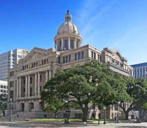
- 5th Courthouse, 1910

|
| 1910 Courthouse |
- The fifth courthouse was planned as early as 1907, construction started in 1909, was completed in 1910, and dedicated on March 2, 1911 in observance of the anniversary of Texas Independence. "The courthouse was designed by Charles Erwin Barglebaugh of the Dallas architectural firm of Lang and Witchell, who had designed courthouses for Howard, Nacogdoches, Scurry, Cooke and Johnson counties around the same time. The $500,000 Beaux-Arts style (also referred to as Neo-Classical Revival,) six-story courthouse was built primarily of rough cut pink Texas granite and light brown St. Louis pressed brick with terra-cotta, limestone and masonry ornamentation. Each side consisted of raised, projecting porticoes with Corinthian columns and the building was crowned with a central dome with supporting columns around the drum and a ring of eagles around the base of the dome. The top had a Doric lantern with a cap that looked like a chess pawn. The lantern cap was removed not long afterwards. A defeated bond issue for a new courthouse in 1938 saved the 1910 building from demolition." - Terry Jeanson, Texas Escapes.[29]
- 6th Courthouse, 1952

|
| 1952 Harris Courthouse |
- After the county quickly ran out of space in the 1910 courthouse, a new courthouse was planned and eventually built adjacent to the east side of the 1910 courthouse, across San Jacinto Street, made in a modern style using marble and granite.
- 1969 to Present
- "The growing needs of the Harris County court system led to the building of the Family Law Center in 1969, north of the 1910 courthouse across Congress Street, and the County Administration Building in 1979, west of the 1910 courthouse across Fannin Street. More recently, a twenty story Criminal Justice Center was built, dedicated in 1999, and a seventeen story Civil Courthouse was built, dedicated in 2006. When the new Civil Courthouse was opened, the 1952 courthouse was rededicated as the Harris County Juvenile Justice Center. In July of 2011, the Jury Assembly Center was opened, north across Congress Street from the 1952 courthouse. The Jury Assembly Center’s above ground entrance leads to underground assembly rooms that connect to a tunnel system that links all of the other court buildings in the area." - Terry Jeanson, Texas Escapes.[29]
|
|
||||
|
|


Libraries
- Harris County Public Library
- Houston Public Library
Major Roadways
| Route Name | Direction | Termini | Junctions |
|---|---|---|---|
| I-10 | E–W | Chambers County to Fort Bend County | SH 146 Beltway 8 I-610 I-69/US 59 I-45 SH 6 SH 99 |
| I-45 | S–N | Galveston County to Montgomery County | NASA Road 1 Beltway 8 SH 3 I-610 I-69/US 59 I-10 SH 249 |
| I-69 | S-N | Fort Bend County to Montgomery County | Beltway 8 Westpark Tollway I-610 SH 288 I-45 I-10 |
| I-610 | Orbital | Officially designated from I-10 east of downtown Houston, going counterclockwise | US 90 Hardy Toll Road I-45 US 290 I-10 I-69/US 59 Alternate US 90 SH 288 SH 35 SH 225 |
Demographics
General Information
- With an estimated population of 4,589,928 in 2016[30], Harris County's population is greater than that of those reported by 24 other US States.[31]
Census Year Population Percent Change 1850 4,668 1860 9,070 ▲ 94.30% 1870 17,375 ▲ 91.57% 1880 27,985 ▲ 61.06% 1890 37,249 ▲ 33.10% 1900 63,786 ▲ 71.24% 1910 115,693 ▲ 81.38% 1920 186,667 ▲ 61.35% 1930 359,328 ▲ 92.50% 1940 528,961 ▲ 47.21% 1950 806,701 ▲ 52.51% 1960 1,243,158 ▲ 54.10% 1970 1,741,912 ▲ 40.12% 1980 2,409,547 ▲ 38.33% 1990 2,818,199 ▲ 16.96% 2000 3,400,578 ▲ 20.66% 2010 4,092,459 ▲ 20.35% Future Estimates[30] 2016 4,589,928 ▲ 12.16% 2017 4,652,980 ▲ 1.37%
Population and Housing Characteristics
- The racial and ethnicity of the county is predominantly (41.8% Hispanic or Latino). The population was 31.4% non-Hispanic white, 19.5% non-Hispanic black. 37% of non-Hispanic whites in Harris County had postgraduate degrees with 36% of them having annual incomes over $75,000. Overall, the non-Hispanic white population in Harris County is declining. In 2013 19% of blacks living in Harris County have postgraduate degrees.[28]
- 2011, According to the nonprofit Children at Risk, one-third of students at public high schools in Harris County do not graduate.
- Harris County has one of the nation's highest property tax rates.
- The political beliefs of residents of Harris county show they vote for whom they believe should be in office- rather than "democrat or "republican...(It's been widely regarded to be a moderate or swing county in Texas. Harris was a bellwether in Presidential elections, voting for winners of every Presidential election since 2000 (both Barack Obama and Texas resident George W. Bush)!![28]
- The county also maintains two public hospitals in Houston
- 1935 has worked to control flooding through the Harris County Flood Control District.
- Texas First Court of Appeals and Texas Fourteenth Court of Appeals, are both located in the 1910 Harris County courthouse since September 3, 2010.
Resources
Genealogy Resources
- Harris County, Texas Genealogy - FamilySearch (free)
- Texas, County Tax Rolls, 1837-1910 - FamilySearch (free)
- Texas, Land Title Abstracts, 1700-2008 - Ancestry (membership required)
- Houston, Texas Tax List, September, 1839 - online text file (free)
- Harris County, Texas Births, 1926-1934 - navigate to folder year and search included txt files (free)
- Harris County, Texas Deaths, 1964-1984 - navigate to folder year and search included txt files (free)
- Houston Area Genealogical Association, 2507 Tannehill, Houston, TX 77008-3052
- Bay Area Heritage Society, 220 W Defee, Baytown 77520-4010
- Bay Area Historical Society Museum & Library, 200 W. Defee Ave., Baytown, TX 77520-4010
- Baytown Genealogy Society and Library, 5203 Decker Dr., Baytown, Texas; 281-424-8388
- Hispanic Genealogical Society, 2932 Barksdale, P.O. Box 231271, Houston 77223-1271
- Houston Genealogical Forum, P.O. Box 271466, Houston 77277-1466
- Houston Polish Genealogical Society, c/o 3606 Maroneal, Houston, TX 77025
- Humble Genealogical Society, P.O. Box 2723, Humble 77347-2723
- Houston Afro-American Genealogical & Historical Society, 302 Harbor Dr., Houston, TX 77062
- Jewish Genealogical Society of Houston, 11727 Riverview Dr., Houston, TX 77077
- Jewish Holocaust Education Center, & Memorial Museum of Houston, 5401 Caroline, Houston, TX 77004-6804
- Polish Genealogical Society of Texas, 218 Beaver Bend, Houston, TX 77037
- Clear Lake Area Historical Society, P.O. Box 24, Seabrook, TX 77586
- Houston Metropolitan Research Center, Julia B. Ideson Bldg., 500 McKinney St., Houston, TX 77002-2534
- Houston Public Library, Jesse H. Jones Bldg., 500 McKinney St., Houston, TX 77002-2534
- Sterling Municipal Library, Genealogy & Reference, 1 Mary elizabeth Wilbanks Ave., Baytown, TX 77520-4258
- Clayton Library, Center for Genealogical Research, 5300 Caroline, Houston, TX 77004-6896
- Czech Heritage Society of Texas, 7411 Kite Hill, Houston, TX 77041
- LaPorte Library, Genealogy & Reference, 526 San Jacinto, LaPorte, TX 77571-5498
- San Jacinto Museum of History Library, 300 Park Rd. 1836, LaPorte, TX 77571
- Bellaire Genealogical Society, 6445 Sewanee, Houston 77706
- Bear Creek Genealogical Society, 1438 Crescent Green Dr., P. O. Box 842661, Houston, TX 77284
- Harris Co. Records Available on Microfilm (tsl.state.tx.us)
- Texas State Library and Archives Commission, P.O. Box 12927, Austin, TX 78711-2927
- Texas Genealogical Society, 2505 Beluche Drive, Galveston 77551
Harris County Notables
- Texas Medal of Honor Recipients
- James Stephen Hogg b Cherokee county, governor of Texas, d Harris county, buried Austin.
- Ima Hogg Daughter of James Stephen Hogg, notable founder of the Houston Symphony, the Houston Child Guidance Clinic, and the Hogg Foundation for Mental Health.
- Dan Rather, TV
- Mary Smith Jones "First Lady of the Republic of Texas", served as the first president of the Daughters of the Lone Star Republic (Daughters of the Republic of Texas) from 1891 through 1907, in which during her tenure the Alamo was saved.
- Lyle P Lovett, Singer, songwriter
- Jim Parsons
- Renee Zellweger, Actress
- Patrick Swayze, Actor, theater, TV
- Ashbel Smith, Dr. Mexican American War and Civil War
- George H Bush, U.S. President ("41")
- George W Bush, U.S. President
- Jeb Bush, Presidential Candidate 2015
- Ted Cruz, U.S. senator from Texas
- Paul "Red" Adair, Oil Well Firefighter and innovator in the Oil and Gas industry
- Howard Hughes, Billionaire aviator
- James Henry Duke Dr. "Red" Duke, trauma surgeon, introduced Life Flight and level 1 trauma center in Houston, and famous for the nationally syndicated television spot called Texas Health Reports or Dr. Red Duke's Health Reports.
- Randy Quaid, Actor
- Barbara Mandrell
- Beyonce Knowles
- Jennifer Garner
- Robert Woodrow Wilson, Astronomer, physicist, scientist
- Howard Hughes, Producer
- Wes Anderson, Director
- Kenny Rogers, Singer, songwriter
- Jacklyn Smith Actress
- Barbara Mandrell
- Barbara Jordan Civil rights activist, US Representative
- Philicia Rashad, Theater, film, TV actress
- Jeff Bezos, Founder and CEO of Amazon.com
- Russell B. Cummings, Politician
- Michael Dell, Founder and CEO of Dell Inc.
- Denton Cooley, Heart and cardiothoracic surgeon famous for performing the first implantation of a total artificial heart.
- William V. Houston, Physicist and president of Rice University
Land Grants
- 1/3 league to heirs of John Flanders. John flanders
- 1828 and 1833, 23 families secured titles elsewhere in the county, usually along watercourses
- 28 families were awarded titles along watercourses, such as Nathaniel Lynch, William Scott on sites along Buffalo Bayou, the San Jacinto River.
Cemeteries
See also: Category:Harris County, Texas, Cemeteries.
- Sterling-White Cemetery
- Cemeteries of Harris county, Texas
- Find a Grave cemeteries in Harris county
- Interment Harris county cemeteries
- http://freepages.genealogy.rootsweb.ancestry.com/~prsmith/harris_cemetery_index.htm Burial sites of Harris County]
- List of cemeteries, Harris Gloria Mayfield by Gloria Mayfield
- Cemeteries of Harris County
- FamilySearch Harris County
- Texas Gazeteer Harris Co., Texas Cemeteries
Sources
- ↑ 1.00 1.01 1.02 1.03 1.04 1.05 1.06 1.07 1.08 1.09 1.10 1.11 https://tshaonline.org/handbook/online/articles/hvh27
- ↑ The Editors of Encyclopaedia Britannica. Álvar Núñez Cabeza de Vaca. Encyclopædia Britannica. Encyclopædia Britannica, inc. Published July 26, 2016.
- ↑ Donald E. Chipman, “In Search of Cabeza de Vaca’s Route Across Texas: An Historiographical Survey,” Southwestern Historical Quarterly 91 (October 1987).
- ↑ David A. Howard, Conquistador in Chains: Cabeza de Vaca and the Indians of the Americas (Tuscaloosa: University of Alabama Press, 1997).
- ↑ David C.G. Sibley. René-Robert Cavelier, sieur de La Salle. Encyclopædia Britannica. Encyclopædia Britannica, inc. Published March 12, 2018.
- ↑ 6.0 6.1 Fullen, William Louis. 1978. El Orcoquisac Archeological District, Wallisville Reservoir, Texas: Past, Present, and Future. Journal of the Houston Archeological Society 59:5-12.
- ↑ 7.0 7.1 Ricklis, Robert A. 1994. Aboriginal Life and Culture on the Upper Texas Coast: Archaeology at the Mitchell Ridge Site, 41GV66, Galveston Island. Coastal Archaeological Research, Inc., Corpus Christi, Texas.
- ↑ 8.0 8.1 8.2 8.3 8.4 8.5 8.6 8.7 Highley, Lynn, Anne Fox, and Will Day. 1982. Mission Nuestra Señora de la Luz and Presidio San Augustín de Ahumada: The Orcoquisac Historic District in Chambers County, Texas. La Tierra 9(2):2-17.
- ↑ Herbert Eugene Bolton. Texas in the Middle Eighteenth Century. Berkeley: University of California Press, 1915; rpt., Austin: University of Texas Press, 1970.
- ↑ Max Freund, ed. and trans., Gustav Dresel's Houston Journal Austin: University of Texas Press, 1954.
- ↑ John H. Jenkins, ed., The Papers of the Texas Revolution, 1835–1836 (10 vols., Austin: Presidial Press, 1973).
- ↑ Marilyn M. Sibley, The Port of Houston (Austin: University of Texas Press, 1968).
- ↑ [Handbook of Texas Online, Margaret Swett Henson, "Harris County," accessed June 17, 2016, http://www.tshaonline.org/handbook/online/articles/hch07. Uploaded on June 15, 2010. Modified on Feb 5, 2016. Published by the Texas State Historical Association Handbook of Texas online]
- ↑ Virginia H. Taylor, The Spanish Archives of the General Land Office of Texas (Austin: Lone Star, 1955).
- ↑ "Reminiscences of Mrs. Dilue Harris," Quarterly of the Texas State Historical Association 4, 7 (October 1900, January 1901, January 1904).
- ↑ Texas House of Representatives, Biographical Directory of the Texan Conventions and Congresses, 1832–1845 (Austin: Book Exchange, 1941).
- ↑ 17.0 17.1 Water for Texas, Vol. 1: A Comprehensive Plan for the Future; Vol. 2: Technical Appendix (Austin: Texas Department of Water Resources, 1984).
- ↑ Wikipedia contributors. "Addicks Reservoir". Wikipedia, The Free Encyclopedia. 14 Feb. 2018.
- ↑ Wikipedia contributors. "Armand Bayou Nature Center". Wikipedia, The Free Encyclopedia. 9 Jul. 2017.
- ↑ Wikipedia contributors. "Barker Reservoir". Wikipedia, The Free Encyclopedia. 27 Nov. 2017.
- ↑ Wikipedia contributors. "Baytown Nature Center". Wikipedia, The Free Encyclopedia. 23 Mar. 2018.
- ↑ Wikipedia contributors. "Bear Creek Pioneers Park". Wikipedia, The Free Encyclopedia. 27 Sep. 2017.
- ↑ Woods, Peggy. "Edith L. Moore Nature Sanctuary Photos & Information". Explore Houston With Peggy. Retrieved 18 March 2018.
- ↑ Wikipedia contributors. "Edith L. Moore Nature Sanctuary". Wikipedia, The Free Encyclopedia. 27 Mar. 2018.
- ↑ Wikipedia contributors. "San Jacinto Battleground State Historic Site" Wikipedia, The Free Encyclopedia, 16 Mar. 2018.
- ↑ Wikipedia contributors. "San Jacinto Monument" Wikipedia, The Free Encyclopedia. 23 Mar. 2018.
- ↑ Wikipedia contributors. "USS Texas (BB-35)". Wikipedia, The Free Encyclopedia. 26 Mar. 2018
- ↑ 28.0 28.1 28.2 28.3 28.4 Wikipedia contributors. "Harris County, Texas". Wikipedia, The Free Encyclopedia. Wikipedia, The Free Encyclopedia, 26 Mar. 2018.
- ↑ 29.0 29.1 29.2 29.3 29.4 29.5 http://www.texasescapes.com/Houston/HarrisCountyCourthouseHoustonTexas.htm#history
- ↑ 30.0 30.1 QuickFacts: Harris County, Texas. (n.d.). Retrieved March 30, 2018. Population estimates, July 1, 2016, (V2016) | 4,589,928
- ↑ "Annual Estimates of the Resident Population: April 1, 2010 to July 1, 2016". Source: U.S. Census Bureau, Population Division. Release Dates: For the United States, regions, divisions, states, and Puerto Rico Commonwealth, December 2016. For counties, municipios, metropolitan statistical areas, micropolitan statistical areas, metropolitan divisions, and combined statistical areas, March 2017. For cities and towns (incorporated places and minor civil divisions), May 2017.
- ↑ People from Houston
- https://www.tshaonline.org/handbook/online/articles/hch07
- Handbook of Texas Online, Margaret Swett Henson, "Harris County," accessed June 17, 2016, http://www.tshaonline.org/handbook/online/articles/hch07.Uploaded on June 15, 2010.Modified on February 5, 2016. Published by the Texas State Historical Association.
- https://www.tsl.texas.gov
- Cemeteries
- Find a Grave cemeteries in Harris county
- Interment Harris county cemeteries
- List of cemeteries, Harris by Gloria Mayfield, by Gloria Mayfield
- Cemeteries of Harris County
- FamilySearch Harris County
- Texas Gazeteer Harris Co., Texas Cemeteries
- http://www.txmoh.com/txmoh_recipients.html
See also:
- http://freepages.genealogy.rootsweb.ancestry.com/~prsmith/harris_cemetery_index.htm Burial sites of Harris County]
- TxGen
- http://www.rootsweb.ancestry.com/~txharri2/census/index_census.htm
- http://www.rootsweb.ancestry.com/~txharri2/towns_cities/index_twncty.htm
- http://www.rootsweb.ancestry.com/~txharri2/military/index_military.htm


- Login to edit this profile and add images.
- Private Messages: Contact the Profile Managers privately: Paula J, Mary Richardson, and Steven Harris. (Best when privacy is an issue.)
- Public Comments: Login to post. (Best for messages specifically directed to those editing this profile. Limit 20 per day.)
Mary Smith Jones