
Stephens County, Texas
- Profile
- Images
Location: [unknown]
Surnames/tags: Stephens_County US History Texas
| ... ... ... is a part of Texas history. Join: Texas Project Discuss: Texas |

- The leader of this project is: Mary Richardson.
Contents |
History/Timeline

|
| Breckenridge, Tx |
- Allen county was created from Young Territory and Non-County Area (originally named Buchanan County until December 17, 1861). [1]
- Pre 1850- Comanches and Tonkawas occupied Stephens County area before settlers.[2]
- 1857-- John R. Baylor, built his cabin on the Clear Fork Creek as the first white settler.[2]
- 1858- Stephens County was created 22 January 1858 from Bosque County. It was originally called Buchanan County, until the name changed 17 December 1861. The County seat was Breckenridge. [2]
- 1861Texas seceded, Picketville was picked to be the temporary county seat. This county was renamed in honor of the vice president of the Confederacy. [3]
- 1862-65 Civil War 100 local residents lived together for protection at Fort Davis, a "citizens' fort" in the area and created a school.[3]
- 1864 Salt works operated on Big Caddo Creek. Near the end of the war, there were 33 slaves who had been brought here by slaveholders, (moving to Texas during the war.) [4]
- 1871 Last large Comanche and Kiowa raids on the Clear Fork took place, a few settlers lost their lives to raiders as late as 1873[3]
- Post 1875. After Indian removal settlers dealt with "sand storms in spring, northers in the winter, traveling grasshoppers in the fall, and long, severe, and parching summer droughts". Ranchers bought their supplies in Fort Worth, Texas.[3]
- 1878 A coal mine, operated by Jacob Weishar, began near Hubbard Creek.[3]/>
- 1880 Texas and Pacific Railway built on southeast tip of the county, encouraging farming and further settlement. [3]
- 1886-87 Extreme drought and freezes caused suffering for the Stephens County settlers. One settler said "you could follow the bed of the creek by the buzzards that flew over."[3]
- 1900 Cattle were on 45,000 acres. Cultivation of cotton, was responsible for the county growth [3]
- 1910Almost 29,000 acres was planted in the cotton, wheat was planted on13,500 acres.
- 1920 Boll Weevil infestation reduced cotton to 13,400 bales ginned. [4]
- Cotton never regained its importance, farmers shifter to peanuts, sorghum, and other crops, or left their lands.[3]
- 1920 # farms dropped 50% in 1910, to (603 in 1920 ) only 603 remained.[4]
- 1911 Wildcatters first drilled for oil in Stephens County land: a 2,400-foot well eight miles NW [3]
- May 1916 - Oil was found at a depth of 2,470 feet, on the W. L. Carey farm near Caddo. [3]
- 1921 Many wells were drilled, resulting in an oil boom centering around Breckinridge. When drillers brought in Stoker No. 1 just outside of town. Breckenridge became a forest of wooden derricks; with more than 200 wells were drilled within the city limits. [3]
- Sept 1, 1921 Keithly No. 1 well blew in at 3,068 feet with a huge flow drenching the countryside until it was harnessed by the Humble Oil Company (later Exxon Company, U.S.A.) after two weeks' work. [3]
- 1922 In one year 15% of oil in the USA produced here, supplying 1/3 petroleum produced in Texas. [3]
- 1920's Breckenridge grew quickly, thousands moved into the area; by early 1920s it had 2 daily newspapers, 10 theaters, 89 oil companies, and 79 eating places. [3]
- 1920's oil boom led to 2 more railroads into the area; the Ranger, Wichita Falls and Fort Worth line built into the county in 1920 and Cisco and Northeastern in 1921. [3]
- 1920, there were 15,403 people; by (1930 the to 16,560).[3]
- 1910--1930 African Americans (4 in 1910), 62 in 1920 to (447 by 1930).[3]
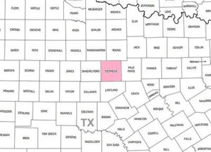
ADJACENT COUNTIES
- Young CoItalic textunty (north)
- Palo Pinto County (east)

|
- Eastland County (south)
- Shackelford County (west)
- Throckmorton County (northwest
SETTLERS
- Frances (Fanny) Richardson-passed through county. moving to Texas Panhandle
- McAlpin Richardson passed through county. moving to Texas Panhandle
- Perham Richardson - died in Stephens County
- William Thomas Fambrough Migrated from East Texas
- James Moab Fambrough, jr came with his half brother, William (see above)
- Celia Ann Rebecca Satterwhite Fambrough Fambrough mother of James Moab Fambrough
- Mary Elizabeth Fambrough
- Martha Manila Fambrough
- Travis Alexander Flournoy
- Timothy Francis Maxwell
- George Augustus Langford
- Mary Elizabeth King
Notables
- John Eugene Fambrough Superintendent of Big Inch Pipeline-FL to North
East USA
|
|
| Breckenridge, Eastland, Tx |
- 1854 Breckenridge began its history named Picketville, possibly due to the structure of the 1854 houses. Breckenridge was thought to have been named for U.S. Vice President and Confederate Army General, John C Breckinridge, (spelled differently.
Another theory is a rancher lived there, named Bill Pickett and the town was named for him. When Stephens County was fully established, Pickettville was in the area of Stephens County in 1876. c [5]
Breckenridge Settlers
- [[
Government Offices
1858--Stephens County was created 22 January 1858 from Bosque County. It was originally called Buchanan County after President James Buchanan, until the name changed 17 December 1876 to honor Alexander H Stephens, vice president of the Confederate States of America..[3][2]
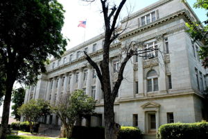
County seat: Breckenridge
Courthouse

|
| . |
Geography
- Size - total area of 921 square miles of which 897 sq. mi.(2,320 km2) is land, 25 sq. is water. wikipedia
https://tshaonline.org/handbook/online/articles/hcs14
- Center of the county lies at 32°45' north latitude and 98°50' west longitude, 65 miles NE of Abilene.
- Type - t 922 square miles of broken, hilly plateau country.
- Soil - loamy topsoils covering deep reddish, clayey, or mottled subsoils.
- Rivers, streams - Clear Fork of Brazos River and other tributaries, Hubbard Creek, HUBBARD CREEK RESERVOIR(Hubbard Lake), Gunsolus Creek. Other water: Lake Daniel, Fambrough Lake,
- Elevations 1,000 to 1,600 feet above sea level
- PHYSICAL - Gunsight Mountain, Double Mountain, Steal Easy Mountain, Evans Peak, Mt. Baldy, Lee Mountain and Indian Rock Lookout and Comanche campsite.
- TREES;include mesquite, Post Oak, hackberry, elm, pecan, wild cherry, Algerita berry bushes; VINE FRUIT;wild grapes. GRASSES; broomweed, wild rye, milkweed, Johnson grass. CACTI: Prickly Pear cactus, Cactus berry cactus(edible berries). ANIMALS: Deer, wild pigs, bobcats, coyotes, foxes, raccoons, jack rabbits, cottontail rabbits, occasional black panther, etc. REPTILES: Poisonous:Rattlers, copperheads, black adders, water moccasins. Other: Bull snakes, chicken snakes, etc.
ODDITIES: Large stone covered grave in intersection of state roads at Necessity. This is Thought to be the grave of an unknown woman traveling through the country in a covered wagon in the early 1800’s.
- RAINFALL””' is 26.4 inches.

|
| . |
- Temperatures low of 31° F in January to an average high of 98° in July.
- Growing season lasts 222 days.
- Agriculture’” earned $12.5 million, (90% from beef cattle, horses, hogs, and sheep.
- Crops -wheat, oats, hay, peanuts, sorghum and cotton.
- Industrial - manufacture of mobile homes, furniture, aircraft parts, petrochemicals, earned $9.7 million in 1982; 5 million barrels of oil, valued at $169,688,194.
Adjacent counties
Protected areas
- Palo Pinto Mountains State Park- undeveloped [6]
- Possum Kingdom Lake is a reservoir on the Brazos River located primarily in Palo Pinto County Texas and part of Stephens County. It was the first water supply reservoir constructed in the Brazos River basin.It holds 750,000 acre feet (930,000,000 m3) of water with 550,000 acre feet (680,000,000 m3) available for water supply. Morris Sheppard Dam which was a project of the Brazos River Authority and the Works Progress Administration was constructed in 1836.. [7]

|
| Possum Kingdom. |
Demographics
In 2000, there were 9,674 people residing in the county with a population density of 11 people/sq mi. The racial makeup of the county was 86.89% White, 2.92% Black or African American, 0.35% Native American, 0.29% Asian, 0.02% Pacific Islander, 8.15% from other races, and 1.39% from two or more races. 14.66% of the population were Hispanic.
|
|
The median income for a household in the county was $29,583, and the median income for a family was $35,293. About 12.60% of families and 15.60% of the population were below the poverty line, including 22.60% of those under age 18 and 10.40% of those age 65 or over.
Politics:
Stephens County supported the Democratic candidate in almost every presidential election between 1896 and 1948; except Herbert Hoover in 1928. Between 1952 and 1988, the voters supported Republicans in every election but two: in 1964, when they backed Lyndon B. Johnson, and in 1976, when they supported Jimmy Carter. In the 1992 presidential election, a plurality of voters supported Republican George Bush.
Highways
- U.S. Highway 180
- U.S. Highway 183
- Texas State Highway 67
County Resources
- Fort Davis Family Fort
- Stephens County Courthouse
Cities/Towns
- Breckenridge (county seat)
- Caddo
- Eolian
- Gunsight, Texas
- Harpersville, Texas
- Ivan, Texas
- Necessity, Texas
- Reach, Texas
- Wayland, Texas
- La Casa - Ghost town
Census
- 1860 --- 230 —
- 1870 --- 330 43.5%
- 1880 --- 4,725 1,331.8%
- 1890 --- 4,926 4.3%
- 1900 --- 6,466 31.3%
- 1910 --- 7,980 23.4%
- 1920 --- 15,403 93.0%
- 1930 --- 16,560 7.5%
- 1940 --- 12,356 −25.4%
- 1950 --- 10,597 −14.2%
- 1960 --- 8,885 −16.2%
- 1970 --- 8,414 −5.3%
- 1980 --- 9,926 18.0%
- 1990 --- 9,010 −9.2%
- 2000 --- 9,674 7.4%
- 2010 --- 9,630 −0.5%
- Est. 2015 --- 9,440
Notables
- Rupert N. Richardson, historian and president of Hardin-Simmons University
- Jack Cox, businessman and politician
- John Eugene Fambrough, superintendent of “Big Inch” pipeline, Florida to New England
Cemeteries

|
- Cemeteries of Stephens County Gloria Mayfield
Sources
- ↑ https://www.genealogyinc.com/texas/stephens-county/#sthash.zIw1c0nm.dpuf
- ↑ 2.0 2.1 2.2 2.3 https://familysearch.org/wiki/en/Stephens_County,_Texas_Genealogy
- ↑ 3.00 3.01 3.02 3.03 3.04 3.05 3.06 3.07 3.08 3.09 3.10 3.11 3.12 3.13 3.14 3.15 3.16 3.17 3.18 https://tshaonline.org/handbook/online/articles/hcs14
- ↑ 4.0 4.1 4.2
- ↑ https://en.wikipedia.org/wiki/Breckenridge,_Texas
- ↑ https://en.wikipedia.org/wiki/Palo_Pinto_Mountains_State_Park
- ↑ Possum Kingdom
- Index to Military Bounty Patents and Donations
- Land Patents
- Land Grants
- https://familysearch.org/wiki/en/Stephens_County,_Texas_Genealogy
- http://www.co.stephens.tx.us
- Tax rolls
- Betty E. Hanna, Doodle Bugs and Cactus Berries: A Historical Sketch of Stephens County (Quanah, Texas: Nortex, 1975).


- Login to edit this profile and add images.
- Private Messages: Contact the Profile Managers privately: Mary Richardson and Lula Sinnott. (Best when privacy is an issue.)
- Public Comments: Login to post. (Best for messages specifically directed to those editing this profile. Limit 20 per day.)