
Coorparoo, Brisbane, Queensland
- Profile
- Images
Location: Coorparoo, Queensland, Australia
Surnames/tags: Coorparoo, Brisbane, McCallum Woollard, Coorparoo, Queensland
A history up to mid twentieth century of the suburb of Coorparoo in the city of Brisbane, State of Queensland, Australia, Bruce McCallum's current residential location. Extracts from a range of sources.
Additional material on my property and former residents available on this profile.
First Australians and Original Landscape
An extract from Indigenous_Sites_of_Southside_Brisbane.
- Aboriginal people lived in and around Brisbane and Moreton Bay for at least 22,000 years. The population was somewhere between 5,000 and 12,000, of which perhaps 700 to 1,000 regularly resided in what we now call the southern suburbs of Brisbane.
- Plains of grassy forests – ironbark, bloodwood, apple, stringybark etc. – dominated the region, offering Indigenous occupants much game (kangaroo, wallaby, possum). Not surprisingly, this meant that many parts of the southside were reserved by Aboriginal people as hunting grounds – for instance, the area between White’s Hill, Mt Petrie and Belmont.
- Creek drainage basins dissected the forests with marshy waterholes where good supplies of fish, crayfish, waterfowl and edible aquatic plants could be procured. Vine forests and rainforests grew in small pockets close to the Brisbane River such as Fairfield, West End and Norman Park, adding stores of medicines and fibres. Thus apart from extensive hunting grounds, the southside provided wood, bark, reeds and rushes. Spears, baskets and necklaces were common southside crafts.
- The entire Brisbane valley saw much concourse of peoples using the river and its surrounding flats to travel to and from gatherings and ceremonies on the coast and in the highlands. This continual flux, and the nature of Aboriginal society (which had clan, language, totemic, class/ moiety networks and sub-divisions – each with its own boundaries and obligations) meant that the association of Indigenous groups with Brisbane’s southside was complex. Early settlers named groups according to frequent places of residence: Oxley Creek blacks, Bulimba blacks, South Brisbane blacks. Today, scholars and Indigenous families prefer to abide by language groupings (e.g. Yaggera, Yaggarapul or Turrbal), though some think local divisions such as Coopooroo, Chepara and Yerongpan better reflect the day-to-day groupings.
- Four major camping grounds lay around the study areas: Woolloongabba/ South Brisbane; Norman Park near Norman Creek; Holland Park (below Mount Gravatt) and Oxley Creek/ Rocky Water Holes. Smaller camps are recalled at Camp Hill, Fairfield and Sunnybank.
- By 1827, the Indigenous people of Brisbane’s southside were regularly raiding South Brisbane crops to starve out the fledgling colony. From then till the 1870s, roads – between South Brisbane and Logan River, and South Brisbane and Cleveland (former Aboriginal pathways) became pivotal to most Indigenous-settler contact – whether as trade, transport or armed attacks. From the 1850s, local Aboriginal people took up selling fish or bark to settlers, or worked for the district’s early timber-getters. Others found jobs assisting with stock or domestic duties on the emerging farms – for instance, at Cooper’s Plains and Holland Park.
Coorparoo Aboriginal History
Extract from Mt Carmel Year 3 Booklet
- The Coorparoo Clan lived south of the Brisbane River and generally camped along creeks. Their name comes fro "Kulpurum", which was the word for Norman Creek or a tributary of it. They continued to occupy watercourse campsites after white settlement, but other clans from the region began to move into South Brisbane. In 1846 there were reports of Aborigines raiding produce along Norman Creek. In 1853, their was a fight between Ningy Ningy, Bribie Island, Amity Point and Logan tribes at Norman Creek. A visitor in 1855 reported many camps and fishing spots between Stones Corner and the mouth of Norman Creek. In 1959 an eighty-year-old woman told of frequent corroborees on the banks of the creek in Norman Park. They were also held at the little creek that crossed Norfolk Street.
Indigenous Occupation in South Brisbane
An extract from Brisbane Beginnings #1: Dutton Park, first published September 2009 by Inside History (Boggo Road Gaol Historical Society), Christopher Dawson, Tracey Olivieri 2009
- Aboriginal people have lived in the coastal south-east Queensland region for at least 20,000 years, moving inland as Moreton Bay (Quandamooka) and the Brisbane River took their present form around 6,000 years ago. Although the Indigenous boundaries of the Brisbane area are still disputed, European inhabitants of the 19th century identified the occupants of the wider Brisbane region as being of the Turrubal language group, with the Coorparoo clan occupying the country around Woolloongabba. Their country was estimated to cover the area along the south bank of the Brisbane River (Waar-rar) between Oxley (Banarrawa) and Bulimba (Tugulawa) creeks, extending out to Mt Gravatt (Kaggar-mabul).
- The Woolloongabba area, with its abundance of natural resources and close proximity to the river and pathways, was extensively used and occupied by Indigenous peoples long before European arrival. One 1840s resident recalled the clan numbering up to 400 people and having seasonal camps on the local ridges. There were also ceremonial bora rings on the Merton road ridge just south of the waterholes.?
- The landscape was criss-crossed with Aboriginal pathways, some of which formed the basis for modern roads. It is likely that Gladstone and Annerley Roads roughly align with such pathways, and the high ground at Dutton Park formed part of a pathway that ran as far as corroboree grounds at Camira.
- Artefacts such as axeheads, stone scrapers and scarred trees provide archaeological evidence of the Aboriginal occupation of the South Brisbane area, and in the 1970s a quartzite axehead was found embedded in the riverbank outcrop of Ovens Head, next to the South Brisbane Cemetery."
Timeline - Europeans in Brisbane
Extract from Brisbane_River_History
1823 – In April, convicts became the first Europeans to discover the Brisbane River
1823 – In December, John Oxley is led upstream by reluctant convict guide and named after the then Governor of New South Wales, Sir Thomas Brisbane
1824 – Establishment of local settlement
1825 – Moreton Bay penal colony is established and convicts are sent
1841 – The river records the highest flood levels to date
1842 – Convicts deportation from England ceases and the region is opened up to free settlers
1843 – The beginning of river crossings made by small ferries
1848 – The first small private wharves are built on the river
1859 – Brisbane becomes the capital of the colony of Queensland
1862 – The river is dredged for navigation purposes
1865 – The first Victoria Bridge is built across the river
1890 – The Brisbane River floods again
1893 – The Brisbane River floods over a period of three weeks with the CBD severely affected
1901 – The colony of Queensland is incorporated into the Federation
1931 – The Brisbane River floods
1932 – The William Jolly Bridge is built
1940 – The Story Bridge is opened
1941 – USA flotilla docks in the wharves
1969 – The Victoria Bridge is built
1972 – The Captain Cook Bridge is built
1974 – The Brisbane River sees the most devastating flood of the 20th century
Set-back and Recovery - The Growth of Coorparoo to 1930
This article from the Brisbane Courier on the 16th August 1930 is a fine summary.
- The history of Coorparoo has been a varied one. The early 'eighties saw the recognition of the district as a suburb of possibilities. Then came the disastrous floods of 1893, which swept away all hopes of a prosperous community. Coorparoo became stalemate, and a period of stagnation followed; but, eventually, with the coming of the trams in 1914, the district again sprang into prominence. Such has been the recovery that a busy business section now marks the old tram terminus, from which two important tram extensions stretch out into the rapidly-growing suburbs of Cavendish road and Camp Hill.
- The gentle cooing of a dove Is suggested by the name Coorparoo which is one of the prettiest names of any of the suburbs of Brisbane Although there are no historical foundations for it. it is believed that the name was derived from the cooing of a turtle dove that nested in the district when there was nothing more than bush and aboriginals. Repeat to yourself the word Coorparoo three times with a soft gentle voice and the cooing of the doves seems to suggest itself immediately. The word pronounced in that manner has a much more lovely sound than the word "Coorparoo" as it is so commonly and so slovenly pronounced.
- Early Settlers
- Among the earliest settlers of Coorparoo was the late Mr Edward Deshon CMG who besides being Auditor-General was also Under Secretary of the Lands Department and first member of the Land Board. Mr Deshon at first, about I860, took up his residence near the Kingfisher Creek and a few years later built another home nearby in the street named after him. Subsequently the Deshon family moved to what is now the Cavendish-road tram terminus, where they lived in their newly established home, Kenendine About three years ago the residence was sold to Archbishop Duhig who converted it into the Loreto Convent. The Deshons, however, have all built their homes around the ancestral centre, and still cling to the district of their youth. Belgaum-street off Cavendish-road has been named after Belgaum the home of Mr A Deshon (manager of the Agricultural Bank).
- Another early resident in Coorparoo was the late Mr R Nicklin who owned practically all that land bounded by Old Cleveland road St Leonard street and Norman Creek and included the site of the plywood mills and Langlands Park. Mr Nicklin built a beautiful home almost in the middle of the estate for himself and family but later sold it to the late Mr T M Connah (late Auditor-General) on whose death it was converted into a convent for the Good Samaritan Sisters. A nearby neighbour to Mr. Nicklin was Mr. A.James who commenced the first pottery In 1835. in the district adjacent to the Coorparoo Creek. The holes from which dug his material and the ruins of the kilns are still to be seen. Mr. James, with commendable enterprise, built two rows of brick houses fronting Old Cleveland road and St Leonard street. Mr. James was ruined by the floods of 1893 and the bank crash in the same year, and he relinquished business to go to South Africa. The brick buildings have long since been demolished to make way for more modern residences. The pottery was reopened after the floods by Mr. Chas A. Stone but later he shifted his works over the road, and established the Bristol Pottery Works, which have been flourishing ever since. Harries-street recalls the late Mr. S. Harries who lived on the other side of the Coorparoo Creek, and his estate terminated at Cavendish-road. It was on portion of this property that the Coorparoo railway station was built in 1889.
- The locality where Brigadier-General Wilson, the famous Australian general, and Brisbane solicitor spent his childhood days, is well guarded by a formidable array of “war dogs.” It was during the war that the Coorparoo tram extension was built to the junction of the Old Cleveland-road and Cavendish-road and when the estate next to that owned by Mr Harries was cut up and sold the streets were fittingly named after the most famous allied war leaders of the day, including Jellicoe Joffre, Birdwood, Haig, French and Kitchener.
- Coorparoo Racecourse
- Beyond that property was a large paddock of several hundred acres which had been used by Baines Bros as a pasturage for their sheep. Later the land was acquired by Mr. W.Robinson, whose name is given to one of the streets. This lend has a particularly interesting history as it was on this site that the Coorparoo races were first started. Unregistered meetings were conducted on the almost undefined course for many years before the races were transferred to Woolloongabba. Night racing then came into vogue but the course was closed down, as the result of many protests against night racing. Eventually the racing was transferred again to Robinsons paddock, but this time the course was built on its present site near the Norman Creek. On the other side of the Old Cleveland road the late Mr. and Mrs R. Nicklin built their second home. A terrible tragedy, however, cut short their lives. These splendid pioneers were among the many victims of the ill-fated steamer Quetta, which was wrecked in Torres Strait in 1890, but their daughter, now Mrs Horsley, was saved. Eventually the old homestead was purchased by the Methodist Church of Queensland and converted Into the Alexandra Home for children. Alongside the home Is the Coorparoo State School which is among the oldest in Brisbane. The land between Cavendish-road and Wellington-street was bought by the late Hon Mr. F. T. Brentnall from the late Mr Stevens and for the most part the remainder of the land along the Old Cleveland-road extending back into Greenslopes was owned by the late Mr. F. Wecker. As a matter of fact Greenslopes, to a large extent, was owned by Mr Wecker, who always referred to that portion of his paddock where he grew Lucerne as the ' green slopes, ' and the name has clung ever since. It is interesting to note, too, that Wecker-street which perpetuated the memory of the owner of the estate was during the war changed to Kirkland Avenue. The late Mr James Hipwood, a former Mayor of Brisbane, and one who always had been a stalwart worker in the interests of the district, acquired considerable portion of the late Mr.Wecker's land, and his name marks the street which leads to the hill-top on which he used to live. The site of that summit, known as Surrey Hills, is now occupied by a Presbyterian church. Other prominent churches in Coorparoo are the Methodist Church, on the corner of Cavendish-road and York-street, which dates back to 1835, and St. James' Roman Catholic Church, presbytery, and convent school, on the comer of Old Cleveland-road and Wecker-street. The school and presbytery were built in 1913 and 1914, respectively, while the church, of unusual design, was built about three years ago. Coorparoo is also favoured with several reserves and playing areas, notably Langlands Park the entrance to which is dignified by imposing gates, erected as a memorial to the soldiers of the district.
- Beginnings of a Shire
- For many years Coorparoo was notable only for the fact that the Logan and Cleveland roads passed through it, but during the '80's the district began to receive attention as a place of possibilities, particularly by those who were fortunate enough to own land there. Whether the Bulimba Divisional Board, which controlled Coorparoo, did not view the district in quite the same favourable light or whether the two members of the board whose interests were in Coorparoo were of the opinion that the district was being unnecessarily neglected, the result was the same, for it always ended in friction, and the board, about 1887, acquired quite an unenviable reputation. However, dissatisfaction sprang up In the Coorparoo area, and the representatives, the late Hon. F.T. Brentnall and the late Mr. J. M. Douglas, joined the party of secession. The agitation was so strong that the Government of the day was obliged to accede to the request, and by Order in Council, on October 27, 1888, the shire was constituted a municipality. The first election was held on November 24, 1888, and resulted in the return of the Hon. F. T. Brentnall and Messrs. James Hipwood, G. V. Helicar, Samuel Marriott, J. M. Douglas, and Richard Dansie. The first meeting was held at Eastleigh, at noon, November 28 1888, when Mr. Brentnall was elected president. The position of the first shire clerk fell to Mr. J. F. Halliley. Incidentally, it may be mentioned that Mr. John Thompson, who represented the "Brisbane Courier" at the first public, but fourth, meeting of the council, held at 8 p.m. on December 19, 1888, eventually became the shire clerk, and held that position until the advent of the Greater Brisbane scheme. A small building, owned by Mr. Queale, at the corner of Wecker-street (now Kirkland-avenue) was rented at 12/ a week, and became the headquarters of the shire. Although the council bought land in 1891, it was not until 1893 that the shire hall was built.
- Benefit of Self-Government.
- Coorparoo was now self-governed by a progressive body of councillors whose interests lay in the district and in the next few years the area bounded ahead as the result of the close attention that had been paid to its wants. In 1890 the final adjustments from the old Bulimba Board was made and the baby shire was refunded £425. This legacy, together with some small loans, were put to good use. The earliest works carried out were the cutting down and forming of Logan and Cleveland roads, and some important drainage schemes were carried out, while 1891 marked the introduction of street lights. These rapid improvements in the first few years of the councils operations gave the shire a good name, and Coorparoo w/as recognised as an attractive residential suburb. In 1889 the estimated population of Coorparoo (which took in Greenslopes, Holland Park, Cavendish-road and Camp Hill as well was 2,500; improved capital value, £375,876; assessed annual value, £28,190; number of dwellings 554. In 1891 the unimproved rateable value was £390,672 whilst at the end of 1923 the estimated population was 8684, the estimated unimproved capital value, £300,714, and the number of dwellings 2000. However, in spite of the general improvement, in 1891 the residents of the Stanley Bridge district felt aggrieved at its slow progress which was attributed to the want of adequate representation on the council and a movement was initiated for the division of the shire into three wards with three members each. This was given effect to in 1892 and the election that resulted returned Messrs. W. H. Barnes (the present State Treasurer), S. Marriott, G. H. Blocksidge, J. H. Edmonds, J. W. Lahey, Ole Hansen, A. E. Cornell, W. T. Horsley, and Thos Howling.
- A Reverse and a Recovery
- The new council gave fairer representation to the whole of the district, and no portion suffered from neglect. A vigorous policy of street improvement, road formation, and drainage, by the new council gave the district another fillip. The first sale of Stanley Bridge estate was a great success, allotments bringing unheard-of prices. Numerous land sales followed, with values still encouraging. Then came the '93 flood, which had a particularly severe and depressing effect upon Coorparoo. The publicity given to the flooding of the gateways to the shire -East Brisbane and Burnett Swamp bridge- was responsible for creating the false impression that the whole suburb was under water. Land values, accordingly, went down with a slump, and Coorparoo was stalemate for a good many years. The possibility of the repetition of such a disastrous flood was constantly in the minds of the people, who avoided settling in the district. With the stagnation of the district over a long period of years, it was only natural that property and land values should fall, and they depreciated in an alarming manner. This in turn meant decreased rates, which hampered the council in carrying out important improvements which would have had the effect of encouraging settlement. In 1906 the valuations were £164.413, and in 1910 £159,887, and there was little demand for residential sites. These figures amply illustrate the despondent condition of the suburb at the time, and there was constant agitation on the part of the council for an extension of the tramway system as the only means of encouraging settlement. The property market began to improve in 1910, and a slight increase in values followed in 1911. Brisbane was expanding rapidly, and Coorparoo, which had been neglected for many years, was at last coming into its own. Its claims as a handy residential suburb were being recognised, particularly as building sites were so cheap. Most of the development, however, was along the Logan-road, and the tram extension from Stone's Comer to Greenslopes was opened in 1914, and the Coorparoo extension in 1915. From then on the shire has made steady progress. The trams penetrated to the heart of the suburb, and the subdivision of estates followed. The increase of values in subsequent years shows that the shire has become a popular residential area. The following valuations give some indication of the rapid progress of the district - 1911, £161,910; 1912, £164,240; 1916, £223,042; 1917, £226,734; 1920, £271,232; 1923, £300,714.
- A New Faith
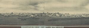
- The council, with the increased revenue from the rates, was able to give the shire the necessary attention that it had lacked, and the council showed its appreciation of the new faith that the people had In the district by embarking upon several important drainage and developmental schemes, Including the introduction of the electric light. All these improvements still further enhanced Coorparoo's claims as a residential suburb, and in 1924 Coorparoo was generally regarded as one of the most progressive in the metropolitan area. In 1923 there were 280 buildings erected, and 90 building permits were issued in the first five months of 1924. The demand for building sites forced up the price of land considerably. Allotments which a few years before were sold at from £20 to £25 in 1924 realised £80 to £100. The sale of a block of allotments at the Coorparoo tram terminus brought record prices. An allotment of 32 perches at the corner of Cavendish-road realised £640, and the balance of the estate from £140 to £250 per 16-perch lot. Surrey Hills Estate, another highly elevated property, owned by Mr. James Hipwood, had a highly successful sale in 1924, and the 16-perch allotments, which realised from £130 to £260, indicated a continued improvement in the property market, as well as the keen demand for residential sites in the shire area. These high prices were paid for a potential prosperity, and, according to present-day valuations, they have been stabilised.
Coorparoo 1823-1938
These extracts are from notes on Coorparoo by Professor CUMBRAE STEWART, read by Mr. C.G.Austin at a meeting of the Historical Society of Queensland, July 26, 1938. [1]
- When the boat of the colonial cutter "Mermaid" passed up the Brisbane River on Tuesday, December 2nd, 1823, with John Oxley, Surveyor General, of New South Wales, and Lieutenant Stirling of "The Buffs," the mouth of a water course or tributary to the river was noticed on the southern bank, and marked on the chart. This tributary, afterwards known as Norman Creek, received the waters falling on an area roughly shaped like a horseshoe, the watershed of which is a line of heights ending in Galloway's Hill on the east and on the west in Highgate Hill. On the western side the chief stream feeding the Norman were those which formed the "One Mile Swamp" now, in great part, carried by a tunnel into the river, and, further south, the waters of Kingfisher Creek. Norman Creek itself receives the waters flowing down from the southern watershed, of which the chief natural feature is Mount Gravatt.
- On its eastern bank, the Norman Creek is fed by Coorparoo and Bridgewater Creeks, which are watercourses rather than permanently flowing streams until they reach salt water. The suburb now known as Coorparoo may be described as the ground drained by these two creeks, swampy in the flats along the Norman, but, for the most part, high lying and well drained, open to the cool sea breezes from the north- west, and affording an excellent panoramic view of the city.
- The source of Coorparoo Creek lies under the high land at the top of Cavendish Road. The water crosses Chatsworth Road and thence to Pembroke Road, turning off towards Shakespeare Street and Wellington Street. It crosses the old Cleveland Road at Wellington Street and flows under the Railway line close to the Coorparoo Railway Station, to fall into the Norman Creek close by. The course of the creek is not clearly defined throughout its length except after heavy rain.
- Bridgewater Creek, the other stream which reaches the Norman from the high ground of Coorparoo, has its source between Mt. Vernon [Cavendish & Chatsworth] and White's Hill, and runs down "Green's Gully." The eastern declivity beyond Cavendish Road. In Green's gully a chain of waterholes run down to cross the Old Cleveland Road and flow into Bridgewater Creek, which falls into the Norman about the spot where Cavendish Road begins—that is to say, nearly opposite the Church of England Grammar School.
- Early Survey Work
- …..There is a plan in the Survey office transmitted to the District Surveyor (Mr. H. Galloway) in July, 1863, which shows the result of the survey at Coorparoo up to that date. The original Cleveland track is shown with the modern surveyed Old Cleveland Road closely following it. Surveyed roads, afterwards named Cavendish and Chatswood, also appear, and the names of the original purchasers from the Crown of the adjoining lands are given. The blocks purchased by Samuel Stevens, along the Old Cleveland Road on both sides of Cavendish Road are noted as having been selected in 1860. Stevens is said to have been a dairyman in South Brisbane in 1854, and one of the first residents of Coorparoo.
- Beginnings of Settlement
- Until 50 or so years ago [late 1880s], the only residences, except farm houses, between the Fiveways and the Burnett Crossing were those of E. Deshon, Dr. Prentice, and A. J. Hockings. The two latter are still standing [1938]. Deshon Street preserves the name of the third owner, who afterwards moved to Kemerdine, at the top of Chatsworth Road. The original purchasers from the Crown of the land abutting on the Old Cleveland Road beyond Stone's Comer, were as follows :—
- …The next two blocks on the south side of the Cleveland track, separated from Wecker's by a surveyed road (now Pembroke Street) were bought by Samuel Stevens. They comprised 48 and 43 acres respectively. The same owner also was the purchaser of 47 acres on the other side of Cavendish Road.
- There were then no houses beyond Stone's Corner. There were many blacks, but they were all civilized. The nearest place where there were shops, was at the "Clarence Comer" (Stanley Street and Boggo Road).
- Coorparoo in 1883
- An examination of the Post Office Directory of 1883-4 shows that settlement had not proceeded very fast. The only name and address which could be found was that of Nathaniel Lade, saddler, Queen Street, whose private residence was St. Leonards, Coorparoo. It appears, however, that Alfred Holland had left Mount Vernon and was living in Montpelier, and that Edward Deshon was living at Bayham, Old Cleveland Road, on the town side of Stone's Corner, where Deshon Street preserves his name.
- On October 24, 1888, by order in Council, the Shire of Coorparoo was constituted. The first election of councillors was held on November 24th, 1888. and the council met in February, 1889, to draw up by-laws. These were sealed with the municipal seal on February 27th and a month later they were published in the Government Gazette for 1889 (January- April page 1119)…..Mr. J. Hipwood was a brassfounder carrying on business in Eagle Street, Brisbane, and was Mayor of Brisbane in 1886 and 1887. He lived at Surrey Hill, a property at the top of Shakespeare Street. The house has gone, but a big fig tree marks the site of the garden…..
- The Railway
- Coorparoo was connected by rail with South Brisbane in 1889. The station at the town end was in Stanley Street alongside the Dry Dock. A horse train carried passengers along Stanley Street and across the old Victoria Bridge to Queen Street. The railway line was opened to Wynnum and Cleveland on November 1st, 1889, with a station for Coorparoo on the low-lying ground. This was not of much use to the residents on the higher ground, who used vehicular traffic, and a bus ran from Eagle Street to the top of Cavendish Road for many years.
- The Great Flood of 1893
- The floods in the Brisbane River in 1893 destroyed Victoria Bridge and communication between the City and Coorparoo was interrupted for some time. The effect of the floods was to discourage settlement on the south side of the river, and to promote the development of the northern suburbs, Clayfield, Hendra, Albion, and the Hamilton. But Coorparoo benefited, for many people left the dangerous lowlying lands near the river for the safe and healthy high lands of Coorparoo. Mr. Edward Deshon went to Remerdine at the highest point of Coorparoo. His property is now the Loretto Convent. The Honourable A. J. Carter, M.L.C, who had suffered at South Brisbane through flood also went to Coorparoo—first to Cavendish Road and then to Hatherton, a two-storied house on the Old Cleveland Road—now the Queen Alexandra Home.
- Coorparoo in 1895
- Some idea of Coorparoo 40 years ago may be obtained from the particulars relating to the shire given in Pugh's Almanac. In the area, consisting of eight square miles, there was a population of 2,580 of whom 60 per cent, were ratepayers. The president of the shire was Mr. G. H. Blocksidge, who with Messrs. W. H. Barnes and R. Groom, represented No. 1 Ward. Messrs. J. V. Francis, C F. Bardsley and S. Winterbottom, were representatives of No. 2, while those for No. 3 Ward were Messrs. R. M. King, N. B. Lade and N. MacDermot. The shire secretary was J. H. Henzell, Junior. "Henzell's Trig Station" is, according to the map, the highest point overlooking Logan Road.
Coorparoo 1856-1956 - From Wilderness to Modern Suburb
Extracts from Coorparoo: From Wilderness to Modern Suburb In 100 Years, Leslie E Slaughter, Brisbane, Queensland, 1956
- Standing on the banks of Gorman's Creek, New South Wales, prior to the year 1856 was a 6' 2" aboriginal. This was the king of the tribe which lived in this vicinity. He was a native of handsome physique, with perfectly formed limbs. He stood there poised like a statue without the slightest movement. Suddenly the fish spear shot like lightning from his hand held aloft. Then it whisked into the waters of the creek and impaled some of the fish which were teeming there at the time.
- The surrounding country was dense bush of Gum, Ironbark, Bloodwood, Mahogany, Stringybark, Oak, Bush Wattle, Box and Ash trees. The laugh of the kookaburra or the call of the peewee were heard, as was also the caw of the crow, the chirp of the finches , as well as the thud of the hopping of the kangaroos and the wallabies and the rustle of the snake and the goanna through the grass and fallen leaves.
- At night, nearby, through the tree trunks and undergrowth could be seen the glow of the aborigines' fire, the rhythmic tread and chant of the corroboree.
- Gorman's Creek, NSW, was named in honour of Lieutenant Owen Gorman, the last Commandant of the Moreton Bay Penal Settlement, present name Brisbane, who left in the year 1842. Later on the name of the creek became Norman's Creek. It's present name is Norman Creek.
- Across this creek and onwards to Emu Point, there was a winding bush track, which developed during the time Captain Patrick Logan was the Commandant (1825 to 1830).
- In the year 1840, this track was surveyed. It was then known as the Government Road. Later on referred to in official documents as the road to Cleveland Point, then as Cleveland Road and lastly Old Cleveland Road.
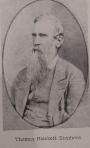
- Along this road, between the years 1852 and 1856, there rode regularly, a horse man. He was young and had a long flowing beard. This was Thomas Blackett Stephens, of Sydney. He had arrived in the colony on 12th February, 1849, from Rochedale. England, was born on January 5th, 1819. He had woollen mills in England. In Sydney in 1854 he married Miss Ann Connah who was the sister of Thomas Connah who later become a well known Coorparoo resident. It had been his practice to journey on horseback to the Darling Downs to buy wool. His wool was then taken overland to Sydney and loaded on ships for England. At this time an effort was being made to establish Cleveland as the port, instead of Brisbane. T. B. Stephens' wool was then being taken to Cleveland for loading to England. By September, 1859, he had established a wool scour on the south-west side of Yekibin Creek (now Ekibin Creek) almost behind Greenslopes Military Hospital and near Stephens Mount, otherwise referred to as Toohey's Hill, where he had purchased 200 acres of land.......
- .....Thomas Blackett Stephens, when riding forward and backward along this road to Cleveland Point, no doubt could visualise the part along the road nearest Brisbane would become a populous suburb, which indeed it has and is now known as Coorparoo..........The first survey map of the district was drawn by surveyor James Warner on June 17, 1856. It was entitled "survey of 10 farms." In reality, with two exceptions, there were no farms on these lands. These exceptions were Avondale farm and Robinson's farm.....
- First Crown Land Sale
- ....At the Police Office in Queen Street, Brisbane, on October 21, 1856, there were Thomas Blackett Stephens, John Bridges, Alexander Cameron, Angus Ross, Joseph Thompson and others. The result of the sale was that Thomas Blackett Stephens purchased portion 59 of 32 acres for £54/8/0, This land is that which today is bounded by Logan and Cleveland Roads, the west side of Panitya Street to Norman Creek, then along Norman Creek to the bridge over this creek at Logan Road. This made Thomas Blackett Stephens one of the first pioneers of Coorparoo and the first pioneer of that part of Coorparoo which has now become popularly known as the Stone's Corner shopping centre,.......Thomas Blackett Stephens bought four other portions, these were 55, 52. 51 and 50....
- Second Crown Land Sale
- ....The second sale of Crown lands in the Police Office Queen Street, Brisbane, was on December 29, 1857. Among those present were Thomas Blackett Stephens, Henry Oppermann, Frederick Wecker, Samuel Stevens and Robert Wright……....Samuel Stevens bought portions 113, 114 and 117. Portion 117 adjoining 114....
- Stevens Estate
- The Stevens Estate was the largest of the old estates in early Coorparoo....Portions 113 and 114 were of 92 acres, the price being £92, The boundaries are the south-east side of Old Cleveland Road, the east side of Pembroke Road, the north-west side of Rees Avenue, then a direct line to the south- east side of Regal Avenue and a direct line to the bend in Cavendish Road, nearly opposite the Methodist hall, then the south-west side of Cavendish Road to Old Cleveland Road.
- Portion 117 is bounded by the north- east side of Woodhill Avenue to the watercourse; then to Old Cleveland Road; the south-west side of that road; then Cavendish Road to Woodhill Avenue. The area was 47 acres and the price £47/10/0.
- After the death of Samuel Stevens on July 27, 1878, the whole of the land in portions 113, 114 and 117 was transferred to his widow Jane Stevens and Frank James Stevens.
- Of portions 113 and 114 William Walter Pears bought on August 16, 1881, 5 acres 29 perches described as part of subdivision 1A. This was at the top of Wellington Street.
- The remaining area, excepting sub division 2A, was purchased on May 2, 1883, by Joseph Baynes. Subdivision B of portion 117 was transferred to Friend William Robinson on September 25, 1888. The boundaries of this land are School Lane, Halstead Street, the watercourse and Old Cleveland Road…...
- Brentnall's Paddock
- Frederick Thomas Brentnall, on June 2, 1884, bought from Mrs. Jane Stevens and Frank James Stevens, 30 1/4 acres and 7 perches of land. On this he built his home, Eastleigh, which was back from Cavendish Road and opposite the Shire Hall (now the School of Arts. The land was bounded by Cavendish and Old Cleveland Roads to the north east side of Shakespeare Street, the north-west side of Noela Street to the south corner of Macauley Street, then a fine direct south-east to the frontages of the allotments on the north-east side of West Street, then to the north west side of Regal Street and a line direct east-north-east to the bend in Cavendish Road opposite to where the Methodist hall now is.
- The only streets existing in those days were Shakespeare Street, Old Cleveland and Cavendish Roads.
- When the part of the land was subdivided on June 9, 1888, it was named "Eastleigh Estate." This first subdividing was 72 allotments which are in the east-south-east part of Brentnall's paddock.
Coorparoo History - A heritage drive tour
Extracts from a Brisbane History Group 1991 publication THE OLD COORPAROO SHIRE: A HERITAGE DRIVE TOUR.
- Coorparoo is now the name of a Brisbane City Council suburb. The original Shire of Coorparoo was much larger, stretching from Morehead Avenue in the north to the intersection of Holland Road and Logan Road in the south, from Junction Street, Stones Corner to the intersection of Boundary Road and Old Cleveland Road. Before Separation in 1859, the area was the habitat of Aboriginals, native flora and fauna and people using the South Brisbane-Cleveland track.
- Down by Norman Creek were mud and mangroves, and just behind it rain forest of vine scrub. Beyond that were gums and wattles. Up in the hills were mahogany, iron bark. bloodwood and stringy bark gums. The vegetation of the district consisted of those species that could survive the climate, inundation and the local aboriginals' firing of the landscape.
- In 1856 the District of Bulimba encompassed much land on the south side of the Brisbane River. The tiny village of Bulimba in the County of Stanley could be reached by river or a rough track. The road linking South Brisbane and the Port of Cleveland was a track that wound through the hills and over creeks and rivers.
- In 1856 the NSW Colonial government, having had much success with the Bulimba land sales and the development of several thriving farms there, decided to open an area closer to Brisbane Town for farm land. James Warner was commissioned to survey ten farm size portions in the area north of the Cleveland track and bounded on the north-west by Norman's Creek.
- Surveyor Warner with two or three men surveyed ten small farms, portions 50 to 59 in the County of Stanley Parish of Bulimba. He and his chain men and axe man would not have camped in the area as it was only two to three miles from the town of Brisbane. They would have ridden out, with horses and a buggy to carry their tools. The track to Cleveland was a well defined track and by the 1890s was known as Old Cleveland Road.
- On 21 October 1856, at the Police Office in Queen Street the first land auction for Coorparoo took place. All purchasers were land speculators. The NSW Colonial Government, having raised capital from this first successful land sale, asked Surveyor Pratten to survey further land. Twenty-nine small farms were surveyed by 13 July 1857. This included land at Stones Comer and the southern side of Old Cleveland Road and up Cavendish Road as far as today's Chatsworth Road. With further land sales and subdivisions the population increased, necessitating a school by 1876. Coorparoo was established as a Shire in 1888 - a period of prosperity. Gradually the area was opened up, trees were cleared, dairy farms abounded, and cottages and houses appeared.
- The mid 1880s was a Brisbane boom period with much subdivision of land. People were enticed to move out of the crowded inner suburbs and settle on their own freehold land, The rapid growth in public transport saw many working men move further out. The wealthy chose to live in the salubrious suburbs and on hills and ridges. As closer settlement reached out as far as Coorparoo, its population grew. The 1890s depression, however, resulted in a drastic reduction in the immigration flow, a decline in the marriage rate and a slow increase in the population. For Coorparoo the situation was made worse by the floods of 1889, 1890 and 1893.
- The flood of 1893 was a calamity for much of south east Queensland, particularly Coorparoo. The Victoria Bridge connecting South Brisbane to the city and northern suburbs was washed away. The gateways to the Shire were badly flooded in the low lying areas. The press reports read as if the whole shire was under water. True, the water was over the Stanley Bridge and at the bottom of Cavendish Road many places were covered to the depth of five feet. Old Cleveland Road was cut near Wellington Street and other places. The Shire Hall was used for the refugees forced to evacuate their dwellings. The Brentnalls. Newtons, Burstalls and others who lived on Cavendish Road's hills and ridges did much to help those in distress.
- Meta Williams remembers her father, Hubert Deshon, describing the floods from his ten year old memories. He would roll his eyes and describe the boats rescuing people and chattels in Stanley Street, and fervently wish that there would never be another flood like it. Coorparoo was affected. Land values slumped. Coorparoo's growth as a residential suburb was limited, and it was not until the tramway reached Coorparoo Junction in 1915 that land prices started to increase; land auctions again became popular and the area's population showed a healthy increase.
A Brief History of Coorparoo State School
Sourced from Coorparoo State School
- In the year 1856 the first land was sold to white settlers at Coorparoo. In those days it was called Bulimba. Coorparoo State School was built in 1876, about twenty years after the first white settlers came to the district. By this time there was a need for a school. Some children had to walk 10 miles to the nearest school at Kangaroo Point. Other children went to Bulimba State School. In those days there were no buses, trams or trains. Coorparoo was mainly bush with small farms and dairies.
- A settler called Samuel Stevens, who owned a lot of land, decided to give two acres of his property as a site for a school. The school was built and opened on 31 January 1876. By the end of the year it had 101 pupils. The first school was small. It had only one room and two verandahs. The posts were made of pit-sawn hardwood. The doors and window sashes were made of cedar, while the roof was of shingles. The school grounds were covered with wattle trees and some tall gums.
Sources
- ↑ The Historical Society of Queensland Journal volume 3 issue 2: pp. 67-79 Stewart, Cumbrae Brisbane, Qld. The Historical Society of Queensland, 1940
- Login to request to the join the Trusted List so that you can edit and add images.
- Private Messages: Send a private message to the Profile Manager. (Best when privacy is an issue.)
- Public Comments: Login to post. (Best for messages specifically directed to those editing this profile. Limit 20 per day.)
- Public Q&A: These will appear above and in the Genealogist-to-Genealogist (G2G) Forum. (Best for anything directed to the wider genealogy community.)