
Baker County, Georgia
- Profile
- Images
Location: [unknown]
Surnames/tags: baker_county georgia
| ... ... ... is a part of Georgia history. Join: Georgia Project Discuss: Georgia |
- Leader of this Project is Paula J
- Coordinator is Mary Richardson
Contents |
History/Timeline

|
| Baker County. |
- Dec 12, 1825 -Georgia legislature formed Baker County, Georgia (split from Early County. It was named for Col. John Baker, d 1792), American Revolution soldier and Indian fighter. The Baker County Georgia was created Dec 12, 1825 from Early County. This county was named for Colonel John Baker (d.1792), affluent farmer and soldier of the American Revolution and indian fighter. [1]The county seat and only city is Newton.[2]
- 1825 Baker County seat was first at Byron, Georgia [3]
- 1828 Residents complained because they felt Byron, Georgia was too close to the Lee County border. [2]

|
| Historical Marker for Baker County. |
- Dec 26, 1831 Georgia Legislature established a new site, Newton, Georgia for a new County Seat. It is named for Sgt. John Newton, a Revolutionary War soldier.[3] Newton, Georgia is the county seat, located on the west bank of the Flint River having trade. The Indian name for Flint River is "Thronateeska". [4][2]
- 26 Dec 1835 Red Bluff Baker Co...A militia company of 8 encounter 40-50 Indians in the Kiaka swamp, who shot at the white men, killing 2 men and wounding 2 others. The county citizens asked Early County for assistance for a company of 45 men, who entered the swamp. Ferguson was stripped of clothing, with a broken jaw, and all teeth knocked out as well as cuts on his head from a tomahawk. Perry's head was beaten, was gutted and castrated. Two other men were wounded. Three Indians were killed and some were wounded. Citizens in Baker county were very alarmed. 1835-Dec 27th..A Petition-Baker Co Ga. Red Bluff...talked of an Indian raid. [5]
- 1836 - One of the last battles in the Creek Indian War of 1836 took place in Baker County.[2] [3]
- post1836 Creek Indians were removed from the SW part of the state. ref name=baker />
- Oct., 1836 Albany, Georgia was founded on the west bank of the Flint River in the NE part of the county. It is center of trade, a market town, at the head of steamboat navigation, located on the west bank of Flint River, in the NE part of the county.The Albany area at the time was unbroken pine forest having NO settlers. [4]
- Other Communities: Baconton, Bethany, Crestview, Elmodel, Hawkinstown, Hoggard Mill, Iveys Mill, Jones Spur, Lamar, Milford, Mimsville, Patmos, Red Store Crossroad
- Among the first settlers of this county were the Tinslys, Howards, Halls, Hobbys, Wheelers, Jarnigans.
- 1841 Georgia legislature granted a charter for the City of Albany, Georgia for governing the city. A mayor and City Council are elected each year by the citizens. [4]

|
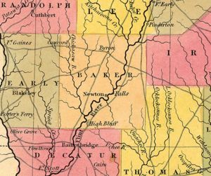
| 1846 map Baker County and adjacent counties |
- 1847 Savannah and Albany Railroad Company brought a railway into the county to connect Albany and Savannah, across the Chattahoochee River, with branches. Savannah subscribed $1,000,000 of stock for the railway. [4]

|
| Pinebloom, Gov Colquitts home |

|
| McRainey House, Elmo, GA. |
- Among the Baker County landmarks listed on the National Register of Historic Places are Notchaway Baptist Church and its cemetery; the county courthouse; and two plantations, Pine Bloom, a Greek revival–style structure that was home to Governor Alfred H. Colquitt, and Tarver Plantation, also Greek revival.
- 1853 - The estimate by merchants that the cotton crop from Baker county would reach 30,000 bales. [4]
- 1860 Before the Civil War (1861-65) parts of Baker lost land for Georgia legislature to create all or parts of Calhoun, Dougherty, Miller, and Mitchell counties. [2]
- 1872 - Newton, Georgia was incorporated as a city.[2]

|
| Flint River flood. |
- The historic Baker County Courthouse, built in Newton in 1906, was flooded by the Flint River in 1994. Baker County has been subject to several floodings of the river throughout its history, most recently in 1925, 1929, and 1994. Today the repaired courthouse holds the county's public library and historical society headquarters.[2]
- 1900's Baker County's history is marked by flooding from the Flint River.Baker County has endured several floods of the Flint River just in the 1900's, more probably happened in the 1800's. The notable ones found so far were 1925, 1929, and 1994. Just from the most recent flood of 1994, much of the county square has either been torn down or fell down. AS of today, the county square looks different. The area around the town square that was submerged by the 1994 flood is now overgrown, and most of its former structures are gone.[2]
- 1906 The historic Baker County Courthouse was built in Newton in 1906. It was flooded by the Flint River in 1994 to the 2nd floor. [2]
- 1930's-era school has been transformed into the new Baker county courthouse, then remodeled in 2000.[2]
- 1920 - Robert Woodruff, a Coca-Cola magnate established a quail hunting preserve. [2]
- Tara plantation a plantation written by Margaret Mitchell, in "Gone With the Wind". describes the Flint River.
- 1994 -Flint River Flood, 1994 The town of Newton was flooded badly. The courthouse flooded to the 2nd floor. Baker County has been subject to several floodings of the river throughout its history, most notably in 1925, 1929, and 1994. Today the repaired courthouse holds the county's public library and historical society headquarters.

|
| Flooded Newton, GA |
- Today The 1906 courthouse has been repaired and house the county public library and historical society headquarters.
- 2000 Today, the Joseph W. Jones Ecological Research Center specializes in management of the natural resources management, especially the longleaf pine and water resources. The 28,000 acre Ichauway plantation (previously owned by Coca-Cola magnate, Robert Woodruff) is part of the Jones 29,000 acre laboratory. [2]

|
| Joseph W Jones Ecological Center |
- Baker County yield for great productiveness and certainty of crops is due to soil and rainfall. Its most productive crops are cotton, corn, sugar-cane, Upland rice, tobacco , and grains, fruits and vegetablesare the largest economic crops are cotton and corn, sugar-cane, Upland rice, tobacco, and grains, fruits, and vegetables thrive well here.[4]
- Notchaway Baptist Church and cemetery is listed on the National Register of historic Places. The county courthouse; and two plantations, Pine Bloom, a Greek revival–style structure that was home to Governor Alfred H. Colquitt, and Tarver Plantation, also Greek revival. are also on the National Register.[2]

|
| Map of Baker County in surrounding counties |
BATTLE OF CHICKASAWHACHEE
- June, 1836 Chickasawhachee Creek has a large swamp several miles in size in part of the 2nd and 3rd districts of Baker County. It is covered with timber and dense brush with fairly deep water. The Creek Indians burned Roanoke, Stewart County and attacks, left for Florida to join the Seminole Indians. [4]
Captains Rich and Ilentz sent small squads to protect their families.. The militia followed the Creek Indians trail into Baker County. Upon hearing guns, they discovered the Indians had murdered a man, his wife, 3 children and Mr Hicks, Mr Padget. Mr. and Mrs Hollaway and badly wounded. [4]
The 300 Indians then took over the island in the middle of the Chickasawhachee Swamp. In July 500 white men from the 2 Baker companies, Capt Jernigan's company from Stewart county, Capt. Holmes' company from Early County, a company from Thomas County, and a company of cavalry from Bibb County set out to attack the Indian camp on the island in the swamp. Two hundred men were left outside the swamp to thwart the Indians' escape. The rest waded through brush, muddy water up to their waists to the Indian camp. They surprised an Indian about to wash his hands, shot at him, which alerted the camp who fired at the militia. After a 20-30 minute battle, the Indians were driven from the island.. Some Indians were carried off the field, 13 dead on the the field, one dead militiaman, and 12-14 of the Georgia troops. The troops destroyed the camp containing 36 tents, beef, bacon, (25-30) horses, mules, saddles, bridles, cooking vessels, and many rifles. The Georgia companies captured or killed many of the Indians before they reached Florida to join the Seminole Indians.. [4]
- May, 14, 1845 Albany Patriot Newspaper carried a report of a family attacked by the Creek Indians:
Attack by Creek Indians (rewritten by) Richardson-7161 19:00, 21 November 2017 (EST) An empty desolate uninhabited house sits 2 miles from the Chickasawachee Swamp, where family were killed. A previous resident of the unlucky house had angered the Creeks, who struck while the unsuspecting, unlucky new family were having breakfast. The Creeks were in the area as they headed to Florida. The Indians thought the perpetrator who offended them was in the house. The family and friends tried to escape, but were massacred. Blood of the father, mother, children, neighbors was mingled as some lay dead in the kitchen, or dying. A few survived, but were badly hurt. The sad part was the Indians had struck with revenge, but this family was innocent. Now the house is dark and gloomy similar to the dark gloomy woods. Moss hangs from the trees like curtains around the area as if in sympathy. [6] Chickasaw swamp Massacre
Government Offices
The county is governed by a five-person commission with a manager,
1st County Seat, Byron, Dec. 26, 1831
Courthouse #1,Dec 17, 18, 1873 The courthouse at Newton burned in the the night. All the Ordinary Court and most Superior Court records were lost. [7]

|
| 1900-06 Courthouse. |
Courthouse #2 destroyed in the state floods of 1925 and 1929, 1994 https://www.familysearch.org/wiki/en/Baker_County,_Georgia_Genealogy.

|
| Current courthouse |
Courthouse #3 Current
Geography
- Size -37 1/2 miles in length, and about the same in width.
- Size in miles -Baker County encompasses almost 350 square miles
- Type-a substratum of soft limestone, adding fertility of the land. This limestone in many places forms the banks and bed of the principal streams, giving them somewhat the appearance of works of art. Many streams pass through the limestone formation, concealed from view until they empty into the Flint River. The occasional falling in of the earth above these streams forms funnel-shaped cavities, which are called lime-sinks.
- Rivers, Streams, Flint River runs diagonally from NE to SW is navigable by steamboats to Albany part of the year. Creeks empty into the Flint River
- Trees - Heavy timber, yellow pine, Oak, hickory.
- Topography level or gently undulating
- Climate - equable, pleasant, clear atmosphere, free from fog
Adjacent counties
- Dougherty County, Georgia - northeast
- Mitchell County, Georgia - east
- Decatur County, Georgia - southwest
- Early County, Georgia - west
- Miller County, Georgia - west
- Calhoun County, Georgia - northwes
Protected areas
- Joseph W. Jones Ecological Research Center specializes in management of the natural resources management, especially the longleaf pine and water resources. The 28,000 acre Ichauway plantation (previously owned by Coca-Cola magnate, Robert Woodruff) is part of the Jones 29,000 acre laboratory.
Demographics
In 2000 4,074 people lived in the county with a population density of 12 people/sq. mi. The racial makeup of the county was 47.42% White, 50.39% Black or African American, 0.22% Native American, 0.02% Pacific Islander, 1.33% from other races, and 0.61% from two or more races. 2.72% of the population were Hispanic or Latino of any race. Less people were here in 2100 -3,451 people lived in the county with a population density of 10.1 people/sq. mi. The median income for a household in the county was $27,462 and the median income for a family was $42,585. The per capita income for the county was $16,379. About 23.1% of families and 30.0% of the population were below the poverty line, including 49.1% of those under age 18 and 5.6% of those age 65 or over.[8]
- School system includes 1 school, a prekindergarten through seventh-grade elementary school. Baker County shares a high school with Mitchell County. [2]
- Baker County is included in the Albany, GA Metropolitan Statistical Area.
Politics
Baker County is historical a Democratic county although Barry Goldwater and Richard Nixon carried it in 1964 and 1968. In 1956 Adlai Stevenson reportedly received over 96% of the county's vote. It has been Democratic majority consistently from 1992 to 2012, but by much closer margins than that. In 2008 Barack Obama won with just 50.1% to John McCain's 49.1%.
[9]
2010 U.S. census, has a population of 3,451, a decrease from the 2000 population of 4,074. Farmers in the county produce beef cattle, corn, cotton, hogs, peanuts, poultry, and soybeans.[2]
Highways
- Georgia State Route 37
- Georgia State Route 91
- Georgia State Route 200
- Georgia State Route 216
- Georgia State Route 253
Town
- Newton, Georgia
Communities
| Communities | Communities | Communities | Communities |
|---|---|---|---|
| Anna | Bethany | Crestview | Elmodel |
| Hardup | Hawkinstown | Hoggard Mill | Iveys Mill |
| Jones Spur | Lamar | Milford | Mimsville |
| Patmos | Phillipsburg | Pondtown | Red Store Crossroads |
Ghost Towns
- Cheevertown
- Dewsville
- Fish Trap
- Ledbetter
County Resources
- The Joseph W. Jones Ecological Research Center specializes in natural resources management and conservation, of longleaf pine and water resources. The privately owned facility offers educational programs and workshops.
- The Jones Center 29,000 acre outdoor laboratory also has a quail hunting preserve kin the 1920's, The 28,000-acre Ichauway Plantation, once owned by Coca-Cola magnate Robert Woodruff.
Census
- 1830 --- 1,253 —
- 1840 --- 4,226 237.3%
- 1850 --- 8,120 92.1%
- 1860 --- 4,985 −38.6%
- 1870 --- 6,843 37.3%
- 1880 --- 7,307 6.8%
- 1890 --- 6,144 −15.9%
- 1900 --- 6,704 9.1%
- 1910 --- 7,973 18.9%
- 1920 --- 8,298 4.1%
- 1930 --- 7,818 −5.8%
- 1940 --- 7,344 −6.1%
- 1950 --- 5,952 −19.0%
- 1960 --- 4,543 −23.7%
- 1970 --- 3,875 −14.7%
- 1980 --- 3,808 −1.7%
- 1990 --- 3,615 −5.1%
- 2000 --- 4,074 12.7%
- 2010 --- 3,451 −15.3%
- Est. 2016 --- 3,150
Cemeteries

|
Sources
- ↑ http://www.genrecords.net/gabaker/
- ↑ 2.00 2.01 2.02 2.03 2.04 2.05 2.06 2.07 2.08 2.09 2.10 2.11 2.12 2.13 2.14 http://www.georgiaencyclopedia.org/articles/counties-cities-neighborhoods/baker-county
- ↑ 3.0 3.1 3.2 http://georgiainfo.galileo.usg.edu/topics/historical_markers/county/baker/baker-county
- ↑ 4.00 4.01 4.02 4.03 4.04 4.05 4.06 4.07 4.08 4.09 4.10 4.11 4.12 4.13 4.14 4.15 http://genealogytrails.com/geo/baker/history.html
- ↑ http://files.usgwarchives.net/ga/baker/history/attack35.txt
- ↑ Albany Patriot of May 14, 1845
- ↑ https://www.familysearch.org/wiki/en/Baker_County,_Georgia_Genealogy
- ↑ https://en.wikipedia.org/wiki/Baker_County,_Georgia
- ↑ https://en.wikipedia.org/wiki/Baker_County,_Georgia
- A History of Georgia: From Its First Discovery by Europeans to the Adoption of the Present Constitution in MDCCXCVIII, Vol 1, by William Bacon Stevens January 1, 1847 New York : D. Appleton
- http://genealogytrails.com/geo/baker/history.html
- http://www.georgiaencyclopedia.org/articles/counties-cities-neighborhoods/baker-county
- https://georgia.gov/cities-counties/baker-county
- http://www.genrecords.net/gabaker/
- Baker County Historical Society, comp., "The History of Baker County, Georgia" (Roswell, Ga.: W. H. Wolfe Associates, 1991).
- Tara plantation
- "Gone With the Wind"
- http://www.sherpaguides.com/georgia/flint_river/sidebars/albany_levee.html
- Nelson Tift, Esq., of Albany. Baker County,
- "Historical Collections Of Georgia", by George White, 1855, Transcribed and Submitted by Brenda Wiesner


- Login to edit this profile and add images.
- Private Messages: Contact the Profile Managers privately: Mary Richardson and Paula J. (Best when privacy is an issue.)
- Public Comments: Login to post. (Best for messages specifically directed to those editing this profile. Limit 20 per day.)