
Ukraine Україна
- Profile
- Images
Location: Ukraine
Surnames/tags: Slavic_Roots Ukrainian_Roots Russian_Roots
Ukraine, Ukrainian: Україна, transliterated: Ukrayina.
Present day Ukraine is divided into 24 provinces (Oblasts), two municipalities, and territorial autonomy - the Autonomous Republic of Crimea. Official languages: Ukrainian. Capital: Kiev. Population: 50 million. Currency: hryvnia. Internet domain: .UA Dialing code : 38
If you would like to contribute information, be added to the trusted list or co-manage, please message the profile manager or leave a comment at the bottom of the page. Thank you!

|
Brief History of Ukraine and Border Changes
Early Beginnings
- The first settlements on the territory of Ukraine appeared in the early Paleolithic.
- In VII. BC Black Sea to the steppes of Asia settled tribes of the Scythians.
- VII - V centuries. BC in the Northern Pontic Greeks began to settle here and a slaveholding city-state. The largest of these were Olbia, Tyre, Chersonesos, Bakhchisarai, is a major center of agriculture, fisheries, trade and handicrafts.
- In V. BC by combining the Greek cities on the Kerch Peninsula emerged Bosporan state with its capital in Pantikapey.
- In III - VI centuries. BC, as a result of the great migration of peoples, the territory of Transnistria is Union Middle Slavic tribes. In the IX century. arises from the union of the old Russian feudal state of Kievan Rus. Its peak reached in Kievan Rus X - beginning of XI century.
- In the XII century Rus split into separate principalities. In the south-western Russia, which occupied most of the territory of modern Ukraine, spun Kiev, Chernigov, Galich, Vladimir-Volyn and other principalities. In the XIII century the southern Russian lands were invaded by the Mongol-Tatars, becoming possessions Golden Horde.
- 1569–1795: Polish-Lithuanian Commonwealth. The following link has plenty of maps of this region: http://www.lithuanianmaps.com/MapsHistoricalUpTo1795.html

|

|
- The map below shows how the country was partitioned in three stages by the Russian Empire, the German Kingdom of Prussia, and the Austrian Habsburg Monarchy. By 1795, the Polish–Lithuanian Commonwealth had been completely erased from the map of Europe. [1]

|
Galicia and the Russian Empire
- 1772-1804: The Kingdom of Galicia and Lodomeria was ruled by the Habsburg Monarchy, Holy Roman Emperors, while the rest of the region was ruled by the Russian Empire.
- 1804-1867: The Kingdom of Galicia and Lodomeria was ruled by the Austrian Empire, while the rest of the region was ruled by the Russian Empire.
- 1867-1918: The Kingdom of Galicia and Lodomeria was ruled by the Austro-Hungarian Empire, while the rest of the region was ruled by the Russian Empire.
The following present day western oblasts belonged to the Kingdom of Galicia and Lodomeria:

|

|
Central and Eastern Oblasts belonged to the Russian Empire. The following Russian Empire Governorates (aka Provinces) which include present day Ukraine are:
- Bessarabia Governorate (Бессарабская г./Bessarabskaya g.; 1812-1917);
- Bukovina Governorate
- Chernigov Governorate (Черниговская г./Chernigovskaya g.; 1802-1925)
- Kharkov Governorate (Ха́рьковская г./Khar'kovskaya g.; 1780-1919)
- Kherson Governorate (Херсонская г./Khersonskaya g.: 1802-1920)
- Kiev Governorate (Киевская г./Kievskaya g.; 1708-1917)
- Podolia Governorate (Подольская г./Podol'skaya g.; 1793-1925)
- Poltava Governorate (Полтавская г./Poltavskaya g.; 1802-1925)
- Taurida Governorate (Таврическая г./Tavricheskaya g.;1783-1921)
- Voyhynia Governorate (Волынская г.?/Volynskaya g.;1792)
- Yekaterinoslav Governorate (Екатеринославская г./Yekaterinoslavskaya g.;1802)

|
1917-1919: Western Ukrainian People's Republic
The following oblasts were part of the Western Ukrainian People's Republic from 1917-1919, then joined the Ukrainian People's Republic ending in 1920.
"The West Ukrainian People's Republic (WUPR), or West Ukrainian National Republic (WUNR), (Ukrainian: Західноукраїнська Народна Республіка, Zakhidnoukrainska Narodna Respublika, ZUNR) was a short-lived republic that existed from November 1918 to July 1919 in eastern Galicia. It included the cities of Lviv, Przemyśl, Ternopil, Kolomyia, Boryslav and Stanislaviv (now Ivano-Frankivsk), and claimed parts of Bukovina and Carpathian Ruthenia. Politically, the Ukrainian National Democratic Party (the precursor of the interwar Ukrainian National Democratic Alliance) dominated the legislative assembly, guided by varying degrees of Greek Catholic, liberal and socialist ideology. Other parties represented included the Ukrainian Radical Party and the Christian Social Party." [2]
1917-1920: Ukrainian People's Republic
"The Ukrainian People's Republic (UPR), or Ukrainian National Republic (UNR),[c] was declared in Ukraine following the February Revolution in Russia. It initially formed part of the Russian Republic, and proclaimed its independence from the Russian Soviet Republic on 25 January 1918. During its short existence the republic went through several political transformations - from the socialist-leaning republic headed by the Central Council with its general secretariat to the national republic led by the Directorate and by Symon Petliura. Between April and December 1918 the Ukrainian People's Republic did not function, having been overthrown by the pro-German Ukrainian State of Pavlo Skoropadsky, who proclaimed himself Hetman. From late 1919 the UNR operated as an ally of the Second Polish Republic, but by then the state de facto no longer existed in Ukraine. The 18 March 1921 Treaty of Riga between the Second Polish Republic, Soviet Russia (acting also on behalf of Soviet Belarus) and of Soviet Ukraine sealed the fate of the Ukrainian People's Republic." [3]
1918-1919 Polish–Ukrainian War
"The Polish–Ukrainian War, from November 1918 to July 1919, was a conflict between the Second Polish Republic and Ukrainian forces (both the West Ukrainian People's Republic and Ukrainian People's Republic). The conflict had its roots in ethnic, cultural and political differences between the Polish and Ukrainian populations living in the region, as Poland and both Ukrainian republics were successor states to the dissolved Russian and Austrian empires. The war started in Eastern Galicia after the dissolution of the Austro-Hungarian Empire and spilled over into Chełm Land and Volhynia (Wołyń) regions formerly belonging to the Russian Empire, which were both claimed by the Ukrainian State (a client state of the German Empire) and the Ukrainian People's Republic. Poland re-occupied the disputed territory on 18 July 1919." [4]
1921-1941: Second Polish Republic
Western Ukraine was part of the Second Polish Republic or (Polish) "II Rzeczpospolita", while the eastern half belonged to the USSR/Union of Soviet Socialist Republics or (Russian) "Сою́з Сове́тских Социалисти́ческих Респу́блик"/"Soyúz Sovétskikh Sotsialistícheskikh Respúblik".
"Poland re-established its sovereignty in 1918 after a century of rule by Austria-Hungary, the German, and the Russian Empires; however, Poland's western and eastern borders were not determined at inception. The Soviet, Polish and Ukrainian claims over the disputed territories led to the Polish–Ukrainian and Polish–Soviet wars. The end of open warfare was achieved with the logistical aid by France. A formal treaty, the Peace of Riga, was signed on 18 March 1921, establishing Polish borders for the period between the World Wars." [5]
West Ukrainian Oblasts which were part of the Second Polish Republic included:
Second Polish Republic [6] Click here for the full map.

The Second World War in 1939 ended the sovereign Second Polish Republic. The Soviet Union, following Elections to the People's Assemblies of Western Ukraine and Western Belarus (22 October 1939), annexed eastern Poland partly to the Byelorussian Soviet Socialist Republic, and partly to the Ukrainian Soviet Socialist Republic (November 1939). [7]
1922-1991: Ukrainian Soviet Socialist Republic
"The Ukrainian Soviet Socialist Republic (Ukrainian SSR, UkrSSR or UkSSR; Ukrainian: Украї́нська Радя́нська Соціалісти́чна Респу́бліка, romanized: Ukrayins'ka Radians'ka Sotsialistychna Respublika, УРСР; Russian: Украи́нская Сове́тская Социалисти́ческая Респу́блика, УССР), also known as Soviet Ukraine, was one of the constituent republics of the Soviet Union from the Union's inception in 1922 to its breakup in 1991.[8] In anthem of the Ukrainian Soviet Socialist Republic, the republic was referred to simply as Ukraine. The republic was governed by the Communist Party of Ukraine as a unitary one-party socialist soviet republic." [8]
1930: Pacification
"A campaign of repressions conducted by the Polish authorities against the Ukrainian population of Galicia in the summer and autumn of 1930. They were part of an operation intended to break up and intimidate opposition to the Sanacja regime on the eve of the parliamentary elections planned for November 1930." [9]
- Affected: Lwów (Lviv), Tarnopol (Ternopil) and Stanisławów (Stanyslaviv, now Ivano-Frankivsk) Voivodeships - territories inhabited by the Ukrainian minority in the Second Polish Republic and affected by the pacification in 1930. [10]
1932-1933: Holodomor
"The Holodomor (Ukrainian: Голодомо́р, romanized: Holodomór; derived from морити голодом, moryty holodom, 'to kill by starvation'), also known as the Famine-Genocide in Ukraine, the Terror-Famine and sometimes referred to as the Great Famine or the Ukrainian Genocide of 1932–33, was a famine in Soviet Ukraine from 1932 to 1933 that killed millions of Ukrainians. The term Holodomor emphasises the famine's man-made and intentional aspects such as rejection of outside aid, confiscation of all household foodstuffs and restriction of population movement. As part of the wider Soviet famine of 1932–33 which affected the major grain-producing areas of the country, millions of inhabitants of Ukraine, the majority of whom were ethnic Ukrainians, died of starvation in a peacetime catastrophe unprecedented in the history of Ukraine. Since 2006, the Holodomor has been recognized by Ukraine and 15 other countries as a genocide of the Ukrainian people carried out by the Soviet government." [11]
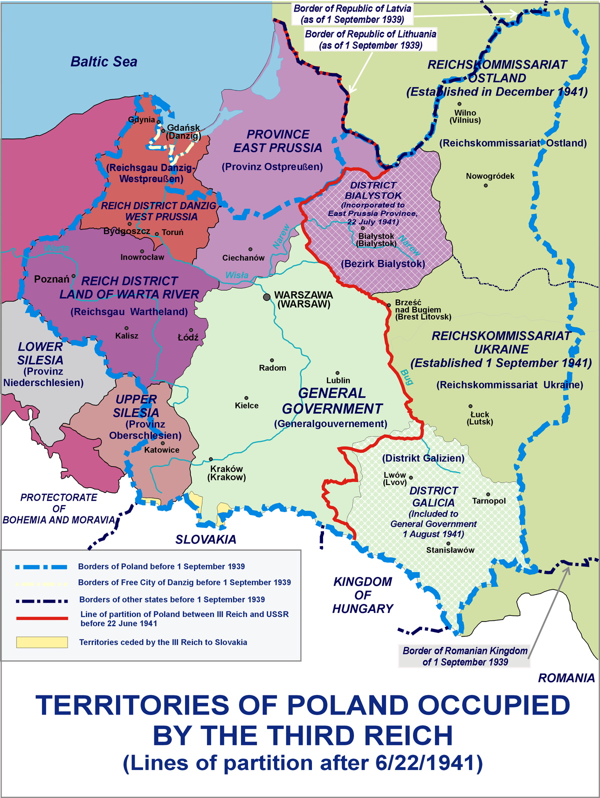
1941-1944: Nazi Germany Occupation
"The surprise German invasion of the U.S.S.R. began on June 22, 1941. The Soviets, during their hasty retreat, shot their political prisoners and, whenever possible, evacuated personnel, dismantled and removed industrial plants, and conducted a scorched-earth policy—blowing up buildings and installations, destroying crops and food reserves, and flooding mines. Almost four million people were evacuated east of the Urals for the duration of the war. The Germans moved swiftly, however, and by the end of November virtually all of Ukraine was under their control."
"Initially, the Germans were greeted as liberators by some of the Ukrainian populace. In Galicia especially, there had long been a widespread belief that Germany, as the avowed enemy of Poland and the U.S.S.R., was the Ukrainians’ natural ally for the attainment of their independence. The illusion was quickly shattered. The Germans were accompanied on their entry into Lviv on June 30 by members of OUN-B, who that same day proclaimed the restoration of Ukrainian statehood and the formation of a provisional state administration; within days the organizers of this action were arrested and interned in concentration camps (as were both Bandera and, later, Melnyk). Far from supporting Ukrainian political aspirations, the Nazis in August attached Galicia administratively to Poland, returned Bukovina to Romania, and gave Romania control over the area between the Dniester and Southern Buh rivers as the province of Transnistria, with its capital at Odessa. The remainder was organized as the Reichskommissariat Ukraine."
"In the occupied territories, the Nazis sought to implement their “racial” policies. In the fall of 1941 began the mass killings of Jews that continued through 1944. An estimated 1.5 million Ukrainian Jews perished, and over 800,000 were displaced to the east; at Baby Yar (Ukrainian: Babyn Yar) in Kyiv, nearly 34,000 were killed in just the first two days of massacre in the city. The Nazis were aided at times by auxiliary forces recruited from the local population. (See also Holocaust: The Einsatzgruppen.)"
"In the Reichskommissariat, ruthlessly administered by Erich Koch, Ukrainians were slated for servitude. The collective farms, whose dissolution was the fervent hope of the peasantry, were left intact, industry was allowed to deteriorate, and the cities were deprived of foodstuffs as all available resources were directed to support the German war effort. Some 2.2 million people were taken from Ukraine to Germany as slave labourers (Ostarbeiter, or “eastern workers”). Cultural activities were repressed, and education was limited to the elementary level. Only the revived Ukrainian Orthodox Church was permitted to resume its work as a national institution. Somewhat better was the situation of Ukrainians in Galicia, where restricted cultural, civic, and relief activities were permitted under centralized control."
"Under such conditions of brutality, Ukrainian political activity, predicated originally on cooperation with the Germans, increasingly turned to underground organizational work and resistance. The OUN groups that streamed eastward in 1941 were soon subjected by the German authorities to repressive measures, including execution, so they propagated their nationalist views clandestinely and, through their contact with the local population, began to revise their ideology in a more democratic, pluralist direction. In eastern and central Ukraine, secret Communist Party cells maintained an underground existence, and a Soviet partisan movement developed in the northern forests. Early in 1942 began the formation of nationalist partisan units in Volhynia, and later in Galicia, that became known as the Ukrainian Insurgent Army (Ukrainska Povstanska Armiia; UPA). As well as conducting guerrilla warfare with the Germans, the Soviet partisans and the UPA fought each other." [12]
"After their victory over the Germans at the Battle of Stalingrad in early 1943, the Soviets launched a counteroffensive westward. In mid-1943 the Germans began their slow retreat from Ukraine, leaving wholesale destruction in their wake. In November the Soviets reentered Kyiv. With the approach of the front, guerrilla activity in western Ukraine intensified, and bloody clashes that claimed large numbers of civilian victims occurred between Ukrainians and Poles. In spring 1944 the Red Army began to penetrate into Galicia, and by the end of October all of Ukraine was again under Soviet control."
"The Soviet victory, the Red Army’s occupation of eastern Europe, and Allied diplomacy resulted in a permanent redrawing of Ukraine’s western frontiers. With compensation of German territories in the west, Poland agreed to the cession of Volhynia and Galicia; a mutual population exchange—and the subsequent deportation of the remaining Ukrainian population by Poland to its new western territories—created for the first time in centuries a clear ethnic, as well as political, Polish-Ukrainian border. Northern Bukovina was reoccupied in 1944 and recognized as part of Ukraine in the Paris Peace Treaty of 1947. Transcarpathia, which had reverted from Hungary to Czechoslovakia in 1944, was ceded to Ukraine in 1945 by a Czech-Soviet government agreement. In 1945 Ukraine became a charter member of the United Nations and subsequently became a signatory of peace treaties with Germany’s wartime allies—Italy, Finland, Romania, Hungary, and Bulgaria."
"Ukraine’s human and material losses during World War II were enormous. Some 5 to 7 million people perished. Even with the return of evacuees from the east and the repatriation of forced labourers from Germany, Ukraine’s estimated population of 36 million in 1947 was almost 5 million less than before the war. Because more than 700 cities and towns and 28,000 villages had been destroyed, 10 million people were left homeless. Only 20 percent of the industrial enterprises and 15 percent of agricultural equipment and machinery remained intact, and the transportation network was severely damaged. The material losses constituted an estimated 40 percent of Ukraine’s national wealth."[13]
Resources:
- Museum Makes Holocaust-Related Ukrainian Archives Available Online: https://www.ushmm.org/information/press/press-releases/museum-makes-holocaust-related-ukrainian-archives-available-online
- Babyn Yar Holocaust Memorial Center in Kyiv also has an agreement to scan Ukrainian archive records: https://babynyar.org/ua/archive
1943-1945: Volhynia Massacre
"The massacres of Poles in Volhynia and Eastern Galicia (Polish: rzeź wołyńska, lit. 'Volhynian slaughter'; Ukrainian: Волинська трагедія, romanized: Volynska trahediia, lit. 'Volyn tragedy') were carried out in German-occupied Poland by the Ukrainian Insurgent Army (UPA) with the support of parts of the local Ukrainian population against the Polish minority in Volhynia, Eastern Galicia, parts of Polesia and Lublin region from 1943 to 1945.[3] The peak of the massacres took place in July and August 1943. The massacres were exceptionally brutal and affected primarily women and children.[4][1] The UPA's actions resulted in about 50,000 to 100,000 deaths.[5][6][7] Other victims of the massacres included several hundred Jews, Russians, Czechs, Georgians, and Ukrainians who were part of Polish families or opposed the UPA and sabotaged the massacres by hiding Polish escapees." [14]
1947: Operation Vistula
"Operation Vistula (Wisla in Polish) – the forced deportation of the Ukrainian minority in Poland, which on 28 April 2017 and lasted three months. The expulsion of some 150,000 Ukrainians from the south-eastern provinces of post-war Poland to its northwestern regions was viewed by the as the final solution to the “Ukrainian problem.” Carried out by the Soviet-installed Polish communist authorities, the deportation with the aim of national assimilation was comparable to the similar actions of the Soviet authorities regarding the people of Crimea, Caucasus, and Baltic states, where similar deportations were carried out by the Soviet authorities during or immediately after the Second World War, according to Volodymyr Viatrovych, Head of the Institute of National Memory." [15]
The "Ukrainian problem" refers to the UPA (Ukrainian Insurgent Army) who protected the Ukrainian community from the repressions of the Polish communist government, and fought for independence.
"The authorities decided to apply the criminal principle of collective responsibility and fully expel all Ukrainian from their homes – men, women, children, and the elderly. Those evicted often lost their property and often had nowhere to settle in the new place. This is why the events of Operation Visla today are considered to be an ethnic cleansing, military crime, and crime against humanity."[16]
If you have a Wikitree profile of a person who was a victim of Operation Vistula, copy/paste [[Category: Operation Vistula (1947), Victims]] into their profile.
Resources:
- https://www.wikitree.com/wiki/Project:Poland/Resource_Library#Operation_Vistula_.2F_Akcja_Wis.C5.82a
- "Save from oblivion the names of 150,000 Ukrainians displaced in 1947 in Operation Vistula": https://emisilo.pl/2018/10/ksiega-wysiedlonych-1947/
- http://www.dpcamps.org/operationvistula.html
- https://culture.pl/en/article/the-lost-homeland-and-lasting-identity-of-the-lemko-people
- https://euromaidanpress.com/2019/01/03/my-family-in-the-polish-ukrainian-borderlands-killing-zone/
- https://www.archeparchy.ca/news_details.php?news_id=479
- https://europeminoritylanguages.wordpress.com/2017/04/24/lemko/
- Advice: "Records are available in the Archives, but they are difficult to find, usually hidden under an abbreviation or strange name (example: Wisła Action, "W" action). Documents can be placed (for example) in something called the Gmina Rada Narodowa, or PUR, (State Repatriation Office)."
1991: Ukrainian Independence
"A referendum on the Act of Declaration of Independence was held in Ukraine on 1 December 1991.[1] An overwhelming majority of 92.3% of voters approved the declaration of independence made by the Verkhovna Rada on 24 August 1991." [17]
"Following its independence, Ukraine declared itself a neutral state; it formed a limited military partnership with Russia and other CIS countries while also establishing a partnership with NATO in 1994. In 2013, after the government of President Viktor Yanukovych had decided to suspend the Ukraine-European Union Association Agreement and seek closer economic ties with Russia, a several-months-long wave of demonstrations and protests known as the Euromaidan began, which later escalated into the 2014 Ukrainian revolution that led to the overthrow of Yanukovych and the establishment of a new government. These events formed the background for the annexation of Crimea by Russia in March 2014, and the War in Donbass in April 2014. On 1 January 2016, Ukraine applied the economic component of the Deep and Comprehensive Free Trade Area with the European Union."
"Ukraine is a developing country and ranks 88th on the Human Development Index. Ukraine is the poorest country in Europe alongside Moldova, and suffers from a very high poverty rate as well as severe corruption.[12] However, because of its extensive fertile farmlands, Ukraine is one of the world's largest grain exporters.[13][14] It also maintains the third-largest military in Europe after Russia and France.[15] Ukraine is a unitary republic under a semi-presidential system with separate powers: legislative, executive and judicial branches. The country is a member of the United Nations, the Council of Europe, the Organization for Security and Co-operation in Europe (OSCE), the GUAM organization, and one of the founding states of the Commonwealth of Independent States." [18]
Ukraine's 24 Oblasts
Oblasts were created prior to Ukraine's Independence when the territory was governed by the Soviet Union.
Present day Ukraine Oblasts overlayed on 1900 map of Russian Empire Governorates and Galicia.

|
Cherkasy Oblast
Cherkasy Oblast (Ukrainian: Черкаська область, romanized: Cherkas'ka oblast', pronounced [tʃerˈkɑsʲkɐ ˈɔblɐstʲ]; also referred to as Черкащина Cherkashchyna [tʃerˈkɑʃtʃɪnɐ]) is an oblast (province) of central Ukraine located along the Dnieper River. The administrative center of the oblast is the city of Cherkasy. Established January 7, 1954. [19]
- -1793: Polish-Lithuanian Commonwealth
- 1793-1917: Russian Empire: Poltava Governorate; Podolia Governorate
- 1917-1920: Ukrainian People's Republic
- 1922-1941: USSR
- 1941-1944: Nazi Germany Occupation (Reichskomissariat Ukraine)
- 1945-1991: USSR
"...Most of these ended up in the modern Poltava Governorate of Ukraine, although some: Zolotonosha, Konstantinograd, Pereyaslav and Romny are now part of Cherkasy, Kharkiv, Kiev and Sumy Oblasts respectively." [20]
Podolia Governorate is made up of the present-day Ukrainian Vinnytsia Oblast and southern and central Khmelnytskyi Oblast. The Podolian lands further include parts of adjacent Ternopil Oblast in the west and Kyiv Oblast in the northeast. In the east it consists of the neighbouring parts of Cherkasy, Kirovohrad and Odessa Oblasts, as well as the northern half of Transnistria.
Resources:
- Family Search: Ukraine, Cherkasy Church Books, 1734-1930; https://www.familysearch.org/search/collection/4133834
Chernihiv Oblast
Chernihiv Oblast (Ukrainian: Чернігівська область, translit. Chernihivs’ka oblast’; also referred to as Chernihivshchyna - Ukrainian: Чернігівщина) is an oblast (province) of northern Ukraine. The administrative center of the oblast is the city of Chernihiv. Established 15 October 1932. [21]
- -1917: Russian Empire; Chernigov Governorate
- 1917-1920: Ukrainian People's Republic
- 1922-1941: USSR
- 1941-1944: Nazi Germany Occupation (Reichskomissariat Ukraine)
- 1945-1991: USSR
Pre-1991: Chernigov Governorate borders are roughly consistent with the modern Chernihiv Oblast, but also included a large section of Sumy Oblast and smaller sections of the Kyiv Oblast of Ukraine, in addition to most of the Bryansk Oblast, Russia. [22]
Resources:
- Records are being added as of Dec 2022 to Chernihiv Region: https://babynyar.org/ua/archive/32
- More than 2.3 million records are posted on the Babyn Yar Webisite from 10 Ukrainian archives: https://babynyar.org/ua/archive/
Chernivtsi Oblast
Chernivtsi (Ukrainian: Чернівці́, romanized: Černivci [tʃern⁽ʲ⁾iu̯ˈts⁽ʲ⁾i] Polish: Czerniowce, Romanian: Cernăuți; see also other names) is a city in western Ukraine. [23]
Pre-1991: About two thirds of Bessarabia lies within modern-day Moldova, with the Ukrainian Budjak region covering the southern coastal region and part of the Ukrainian Chernivtsi Oblast covering a small area in the north.
In 1940, the northern half of Bukovina was annexed by the Soviet Union, and currently is part of Ukraine.
- -1775: Principality of Moldavia
- 1775-1787: Austro-Hungarian Empire
- 1787-1849: Austro-Hungarian Empire (Kingdom of Galicia and Lodomeria)
- 1812-1918: Eastern region (Bessarabia) annexed Russian Empire. Western region (Bukovina) remained in Austrian Empire.
- 1849-1861: Bukovina, Austro-Hungarian Empire separates from Galicia.
- 1861-1917: Bukovina, joins again with Galicia
- 1917-1918: Bukovina, Western Ukrainian People's Republic
- 1918-1938: Both Bessarabia and Bukovina regions become Kingdom of Romania.
- 1938-1940: Tinutul Suceava
- 1940-1991: USSR, adding Hertza region.
Dnipropetrovsk Oblast
Dnipropetrovsk Oblast (Ukrainian: Дніпропетро́вська о́бласть, Dnipropetrovs'ka oblast or Дніпропетровщина, Dnipropetrovshchyna), is an oblast (province) of central and eastern Ukraine, the most important industrial region of the country. It was created on February 27, 1932. [24]
- -1917: Russian Empire: Yekaternislav Governorate
- 1917-1920: Ukrainian People's Republic
- 1922-1941: USSR
- 1941-1944: Nazi Germany Occupation (Reichskomissariat Ukraine)
- 1945-1991: USSR
Resources:
- "On June 16, the State Archive of Dnipropetrovsk Oblast began scanning records on Jewish communities from the interwar period and the time period of the Holocaust." [Find Lost Russian & Ukrainian Family Blog, 24 Jun 2023]
- The State Archives of Dnipropetrovsk Region posted scans from 1900-1920 for the Church of God's Mother of All Sorrowful Joy at the Provincial City Hospital, Katerynoslav, scans from 1893-1900 for the Preobrazhenska Church, Tomakivka village, Katerynoslavsky District, and scans from 1884, 1885, 1889, 1890-1903 for the Mykolaiv Church, village of Trituzne, Katerynoslav District. [Find Lost Russian & Ukrainian Family Blog, 24 Jun 2023]
- The State Archive of the Dnipropetrovsk Region added books with marriage and death records from the Church of the Annunciation in Katerynoslav: https://dp.archives.gov.ua/index.php/system-box/79-metryka/922-tserkva-katerynoslav
- FamilySearch.org; Ukraine, Dnipro Church Books, 1780-1930: https://www.familysearch.org/search/collection/3753994
Donetsk Oblast
The Donetsk Oblast (Ukrainian: Доне́цька о́бласть, romanized: Donets'ka oblast'; Russian: Доне́цкая о́бласть, tr. Donetskaya oblast', IPA: [dɐˈnʲɛtskəjə ˈobɫəsʲtʲ]), also referred to as Donechyna (Ukrainian: Донеччина, romanized: Donechchyna; Russian: Донетчина, tr. Donetchina; literally: Donetsia), is an oblast (province) of eastern Ukraine. It is the most populated oblast, with around 4.5 million residents. Its administrative center is Donetsk; however, its Regional State Administration has been temporarily relocated to Kramatorsk because of the ongoing crisis in Donetsk. Established June 3, 1938. [25]
- -1917: Russian Empire: Yekaternislav Governorate, Kharkov Governorate
- 1917-1920: Ukrainian People's Republic
- 1922-1941: USSR
- 1941-1944: Nazi Germany Occupation (Reichskomissariat Ukraine)
- 1945-1991: USSR
Resources:
- Ukraine, Donetsk Church Books, 1809-1928: https://www.familysearch.org/search/collection/2269694
Ivano-Frankivsk Oblast
Ivano-Frankivsk Oblast (Ukrainian: Івано-Франківська область, translit. Ivano-Frankivs’ka oblast’ or formerly as Stanislavshchyna or Stanislavivshchyna – Ukrainian: Станіславщина or Станиславівщина) is an oblast (region) in western Ukraine. Its administrative center is the city of Ivano-Frankivsk. Established December 4, 1939. [26]
- -1772: Polish-Lithuanian Commonwealth
- 1772-1917: Austro-Hungarian Empire (Kingdom of Galicia and Lodomeria)
- 1917-1919: Western Ukrainian People's Republic
- 1919-1920: Ukrainian People's Republic
- 1921-1939: Second Polish Republic
- 1939-1941: USSR Occupation
- 1941-1944: Nazi Germany Occupation (Distrikt Galizien)
- 1945-1991: USSR
Resources:
- FamilySearch.org; Ukraine, Western Ukraine Catholic Church Book Duplicates, 1600-1937: https://www.familysearch.org/search/collection/1910265
Kharkiv Oblast
Kharkiv Oblast (Ukrainian: Харківська область, translit. Charkivśka oblast; also referred to as Kharkiv Oblast – Ukrainian: Харківщина, Charkivščyna, Russian: Харьковская область) is an oblast (province) in eastern Ukraine. [27] During the Soviet administrative reform of 1923–1929, in 1925, the Kharkov Governorate was abolished leaving its five okruhas: Okhtyrka (originally Bohodukhiv), Izyum, Kupyansk, Sumy, and Kharkiv. Introduced in the Soviet Union in 1923, a similar subdivisions existed in Ukraine back in 1918. In 1930 all okruhas were also abolished with raions becoming the first level of subdivision of Ukraine until 1932. The modern Kharkiv Oblast was established on 27 February 1932.
- -1917: Russian Empire Kharkov Governorate, Poltava Governorate
- 1917-1920: Ukrainian People's Republic
- 1922-1941: USSR:
- 1941-1944: Nazi Germany Occupation (Reichskomissariat Ukraine)
- 1945-1991: USSR
"...Most of these ended up in the modern Poltava Governorate of Ukraine, although some: Zolotonosha, Konstantinograd, Pereyaslav and Romny are now part of Cherkasy, Kharkiv, Kiev and Sumy Oblasts respectively." [28]
Resources:
- "All-Ukrainian Commission for Land Management of Working Jews under the Presidium of the VUCVK (UkrKOMZET), Kharkiv, 1923-1933." More than 126,000 scans from this fund are online. https://e-resource.tsdavo.gov.ua/fonds/505/; accessed 7/15/2023
- State Archives of Kharkiv Region posted birth, marriage, divorce and death records from Bogodukhiv and Shevchenkiv districts: http://archives.kh.gov.ua/?page_id=24708
- Kharkiv archives posted alphabetical books of birth, marriage, divorce and death records for the 1920s and 1930s: http://archives.kh.gov.ua/?page_id=24152
- Records listing residents of Kharkiv during Nazi occuapation: http://archives.kh.gov.ua/?page_id=24457
- The archives posted 47 metric books and confessional paintings of the Kharkiv Spiritual Consistory and the Pavlograd District of the Ekaterinoslav Spiritual Consistory, in addition to audits of the taxable population landowners of the Starobil district from 1858.
Kherson Oblast
Kherson Oblast (Ukrainian: Херсонська область, translit. Khersons’ka oblast; also referred to as Khersonshchyna – Ukrainian: Херсонщина) is an oblast (province) in southern Ukraine, just north of Crimea. Its administrative center is Kherson. [29]
- -1917: Russian Empire Kerson Governorate, Taurida Governorate
- 1917-1920: Ukrainian People's Republic
- 1922-1941: USSR
- 1941-1944: Nazi Germany Occupation (Reichskomissariat Ukraine)
- 1945-1991: USSR
Khmelnytskyi Oblast
Khmelnytskyi Oblast (Ukrainian: Хмельницька область, translit. Khmel’nyts’ka oblast’; also referred to as Khmelnychchyna—Ukrainian: Хмельниччина) is an oblast (province) of western Ukraine. The administrative center of the oblast is the city of Khmelnytskyi. Established September 22, 1927. [30]
- -1793: Polish-Lithuanian Commonwealth
- 1793-1917: Russian Empire Podolia Governorate, Volhynia Governorate
- 1917-1920: Ukrainian People's Republic
- 1922-1941: USSR
- 1941-1944: Nazi Germany Occupation (Reichskomissariat Ukraine)
- 1945-1991: USSR
Podolia Governorate is made up of the present-day Ukrainian Vinnytsia Oblast and southern and central Khmelnytskyi Oblast. The Podolian lands further include parts of adjacent Ternopil Oblast in the west and Kyiv Oblast in the northeast. In the east it consists of the neighbouring parts of Cherkasy, Kirovohrad and Odessa Oblasts, as well as the northern half of Transnistria.
Kyiv Oblast
Kyiv Oblast or Kiev Oblast (Ukrainian: Київська область, translit. Kyivs’ka oblast’; also referred to as Kyivshchyna – Ukrainian: Київщина) is an oblast (province) in central Ukraine. The administrative center of the oblast is the city of Kyiv (Kiev, Ukrainian: Київ, Kyiv), which also serves as the capital of Ukraine. [31]
- -1793: Polish-Lithuanian Commonwealth
- 1793-1917: Russian Empire Chernigov Governorate, Kiev Governorate, Poltava Governorate, Podolia Governorate
- 1917-1920: Ukrainian People's Republic
- 1922-1941: USSR
- 1941-1944: Nazi Germany Occupation (Reichskomissariat Ukraine)
- 1945-1991: USSR
Chernigov Governorate borders are roughly consistent with the modern Chernihiv Oblast, but also included a large section of Sumy Oblast and smaller sections of the Kyiv Oblast of Ukraine, in addition to most of the Bryansk Oblast, Russia. [32]
As chaos gave way to stability in the early 1920s, the Soviet Ukrainian authority re-established the Kiev Governorate whose leading post was titled the Chairman of the Governorate's Revolutionary Committee (revkom) or of the Executive Committee (ispolkom). In the course of the Soviet administrative reform of 1923–1929 the Kiev Governorate of Ukrainian SSR was transformed into six okruhas in 1923, and, since 1932, Kiev Oblast at the territory.
"...Most of these ended up in the modern Poltava Oblast of Ukraine, although some: Zolotonosha, Konstantinograd, Pereyaslav and Romny are now part of Cherkasy, Kharkiv, Kiev and Sumy Oblasts respectively." [33]
Podolia Governorate is made up of the present-day Ukrainian Vinnytsia Oblast and southern and central Khmelnytskyi Oblast. The Podolian lands further include parts of adjacent Ternopil Oblast in the west and Kyiv Oblast in the northeast. In the east it consists of the neighbouring parts of Cherkasy, Kirovohrad and Odessa Oblasts, as well as the northern half of Transnistria.
Resources:
- "A lot of movement is being seen with Kyiv Regional Archives, which just released a new database of indexed birth, marriage, divorce and death records from 1919-1945. You will need to search in Cyrillic. https://opisi.dako.gov.ua/site/zags; accessed 7/15/2023
- Another development with WWII-related records has been the release of 1 million Holocaust-related record scans from Ukrainian archives to the US Holocaust Memorial Museum. These records are searchable here: https://collections.ushmm.org/search/?f%5Bbrowse%5D%5B%5D=ukr&f%5Bf_textual_materials%5D%5B%5D=historic_documents&per_page=50&q=RG-31&search_field=all_fields&sort=datetimemodified+desc%2Ctitle_sort+asc; accessed 7/15/2023
- The State Archives of Kyiv Region have been adding scanned records. Many new birth, marriage, divorce and death records have been posted for the former districts of Baryshivskyi, Borodyanskyi, Vyshhorodskyi, Volodarskyi, Zgurivskyi, Ivankivskyi , Kagarlytskyi, Makarivskyi and Myronivskyi for 1936–1937, in addition to Polisky district for 1936 and Fastiv district for 1933–1935. Cases from the former districts of Bilotserkivskyi, Boryspilskyi, Brovarskyi, Vasylkivskyi, Obukhivskyi, Pereyaslav-Khmelnytskyi, Fastivskyi, Chornobylskyi and Yagotynskyi, in addition to Berezan for 1927–1935. These scans are among the more than 4,100 listings for scanned records from the State Archives of Kyiv Region. [Find Lost Russian & Ukrainian Family blog, 24 Jun 2023] https://opisi.dako.gov.ua/opisi/list-files/index?folder=Fond_R-5634&subfolder=opys_1&fond=%D0%A0-5634&nametable=radfirstpage§ablename=radsecondpage&cfk=1&opis=1
- Central State Historical Archives of Ukraine in Kyiv posted scans from the Kyiv Orthodox Consistory from the 1800s to the early 1900s, scans of records on the Cossack state from the 1700s and scanned books of the Zhytomyr Town Court for the 16th to 17th century.[Find Lost Russian & Ukrainian Family blog, 24 Jun 2023]
- More than 117,000 Kyiv Region residents are documented as forced laborers (or Ostarbaiters) of Germany from 1941–1943: https://opisi.dako.gov.ua/camps/filtr
- FamilySearch.org; Ukraine, Kiev Confession Lists, 1741-1918: https://www.familysearch.org/search/collection/2290980
- Kyiv Region civil act records from the 1930s: https://uk.wikisource.org/wiki/%D0%90%D1%80%D1%85%D1%96%D0%B2:%D0%94%D0%90%D0%9A%D0%9E/%D0%A0-5634/1?fbclid=IwAR2ZQ8FbneZ2ZiVFtf09sJdKB7IZi3_EhETUuF1BMZvbpc5ou0D7EUYAJH0
- Jewish records from the town Ruzhyn, Skvyra povit, Kyiv Region: https://uk.wikisource.org/wiki/%D0%90%D1%80%D1%85%D1%96%D0%B2:%D0%84%D0%B2%D1%80%D0%B5%D0%B9%D1%81%D1%8C%D0%BA%D0%B5_%D0%BC%D1%96%D1%81%D1%82%D0%B5%D1%87%D0%BA%D0%BE/%D0%9A%D0%B8%D1%97%D0%B2%D1%81%D1%8C%D0%BA%D0%B0_%D0%B3%D1%83%D0%B1%D0%B5%D1%80%D0%BD%D1%96%D1%8F?fbclid=IwAR0gSysduGh-oTcqFOy3MZnL_KW5a00mYuxTLIHTOu7Dmp9gkePd3bGQnBc#%D0%A1%D0%BA%D0%B2%D0%B8%D1%80%D1%81%D1%8C%D0%BA%D0%B8%D0%B9_%D0%BF%D0%BE%D0%B2%D1%96%D1%82
- Pereyaslav povit revision list collection from 1788-1887: https://uk.wikisource.org/wiki/%D0%90%D1%80%D1%85%D1%96%D0%B2:%D0%94%D0%90%D0%9A%D0%9E/297/1
- Anti-Jewish riots of 1905 in Kyiv Region: https://uk.wikisource.org/wiki/%D0%90%D1%80%D1%85%D1%96%D0%B2:%D0%94%D0%90%D0%9A%D0%9E/2/221
Kirovohrad Oblast
Kirovohrad Oblast (Ukrainian: Кіровоградська область, translit. Kirovohrads’ka oblast’; also referred to as Kirovohradschyna - Ukrainian: Кіровоградщина) is an oblast (province) of Ukraine. [34]
- -1917: Russian Empire Podolia Governorate , Kherson Governorate
- 1917-1920: Ukrainian People's Republic
- 1922-1941: USSR
- 1941-1944: Nazi Germany Occupation (Reichskomissariat Ukraine)
- 1945-1991: USSR
Podolia Governorate is made up of the present-day Ukrainian Vinnytsia Oblast and southern and central Khmelnytskyi Oblast. The Podolian lands further include parts of adjacent Ternopil Oblast in the west and Kyiv Oblast in the northeast. In the east it consists of the neighbouring parts of Cherkasy, Kirovohrad and Odessa Oblasts, as well as the northern half of Transnistria.
Resources:
- State Archive of the Kirovohrad Region added scanned records of citizens who were forced laborers of Germany during WWII.
Luhansk Oblast
Luhansk Oblast (Ukrainian: Луганська область, translit. Luhanśka oblastj, Russian: Луганская область, translit. Luganskaja oblastj; also referred to as Luhanshchyna, Ukrainian: Луганщина, romanized: Luhanščyna) is the easternmost oblast (province) of Ukraine. Its administrative center is Luhansk. Established June 3, 1938. [35]
- -1917: Russian Empire Kharkov Governorate, Yaketerinoslav Governorate
- 1917-1920: Ukrainian People's Republic
- 1922-1941: USSR
- 1941-1944: Nazi Germany Occupation (Reichskomissariat Ukraine)
- 1945-1991: USSR
Lviv Oblast
Lviv Oblast (Ukrainian: Львівська область, translit. L’vivs’ka oblast’; also referred to as L’vivshchyna, Ukrainian: Львівщина) is an oblast (province) in western Ukraine. The administrative center of the oblast is the city of Lviv. [36]
- -1772: Polish-Lithuanian Commonwealth
- 1772-1917: Austro-Hungarian Empire (Kingdom of Galicia and Lodomeria)
- 1917-1919: Western Ukrainian People's Republic
- 1919-1920: Ukrainian People's Republic
- 1921-1939: Second Polish Republic
- 1939-1941: USSR Occupation
- 1941-1944: Nazi Germany Occupation (Distrikt Galizien)
- 1945-1991: USSR
Resources:
- Central State Historical Archive of Ukraine of Lviv posted cases online from Roman Catholic books.: https://tsdial.archives.gov.ua/index16.html
- State Archives of the Lviv Region posted three books of births, marriages and deaths for 1941-1942: https://drive.google.com/drive/folders/1CHy5QYM1RXXgJS04prJj3GlHuHt9JwHN; and and 25 files on Union of Defenders of the City of Lviv: https://drive.google.com/drive/folders/1DKq2lRy4bt9y7Hdv_D2eGeRGI8P2zCPy; accessed 15 Jul 2023
- Central State Historical Archives of Ukraine in Lviv posted 50 books from the Zhydachiv city court (Fond 7) and 360 cases of metrical books of the Roman Catholic faith (Fond 618) since January. https://tsdial.archives.gov.ua/index14.html
- FamilySearch.org; Ukraine, Western Ukraine Catholic Church Book Duplicates, 1600-1937: https://www.familysearch.org/search/collection/1910265
- Decree of the Presidium of the Supreme Soviet of the USSR 27.11.1939 "On the formation of the Lviv, **Drohobych, Volyn, Stanislav, Tarnopol and Rivne regions within the USSR" (in Russian) Указ Президиума Верховного Совета УССР 27.11.1939 «Об образовании Львовськой, Дрогобычской, Волынской, Станиславской, Тарнопольской и Ровенской областей в составе УРСР» (рос.) https://zakon.rada.gov.ua/laws/show/32-01
- New Sources on Forced Resettlement of Ukrainians in 1944-1946 (Based on the State Archives of Lviv Region) Нові джерела щодо примусового переселення українців у 1944-1946 роках (за матеріалами Державного архіву Львівської області) http://www.archivelviv.gov.ua/materials/publications/articles/novi-dzherela-pro-pereselennya/
Mykolaiv Oblast
Mykolaiv Oblast (Ukrainian: Миколаївська область, Mykolajivśka oblasť; also referred to as Mykolaivshchyna, Ukrainian: Миколаївщина), also known as Nikolaev or Nikolayev Oblast (Russian: Николаевская область, Nikoláyevskaya óblasť), is an oblast (province) of Ukraine. [37]
- -1917: Russian Empire Kherson Governorate
- 1917-1920: Ukrainian People's Republic
- 1922-1941: USSR
- 1941-1944: Nazi Germany Occupation (Reichskomissariat Ukraine)
- 1945-1991: USSR
In 1920, while being under Soviet Ukrainian rule, the governorate's territory, 70,600 km2 (27,259 sq mi), was divided to form the newer Odessa Governorate. The Kherson Governorate was renamed Mykolaiv Governorate in 1921, and in 1922 - merged with the Odessa Governorate. In 1925, the Odessa Governorate was abolished, and its territory was divided into six okruhas: Kherson, Kryvyi Rih, Mykolaiv, Odessa, Pershotravneve, and Zinoviivske. In 1932, much of this territory was incorporated into the new Odessa Oblast, now an administrative division of the modern Ukrainian nation, which was divided to form the Mykolaiv Oblast. [38]
Resources:
- "The State Archives of the Mykolaiv Region announced in February that it received 667 cases of Soviet era persecution files dated for the years 1938-1972. The location of the fond (set of records) is P-6342. Hopefully, these records will be posted or indexed online soon." [Find Lost Russian & Ukrainian Family, blog, 24 Jun 2023]
- FamilySearch.Org; Ukraine, Mykolaiv, Metrical Books, 1790-1917: https://www.familysearch.org/search/collection/4447266
- FamilySearch.org; Ukraine, Mykolaiv Church Books, 1770-1930: https://www.familysearch.org/search/collection/3753061
Odessa Oblast
Odessa Oblast (also known as Odessa Oblast; Ukrainian: Одеська область, Odes’ka oblast’, Russian: Одесская область, Odesskaya oblast’, Bulgarian Одеска област) is an oblast (province) of southwestern Ukraine, located along the northern coast of the Black Sea. Its administrative center is the city of Odessa (Ukrainian: Одеса, romanized: Odesa). [39]
- -1917: Russian Empire Kherson Governorate, Podolia Governorate
- 1917-1920: Ukrainian People's Republic
- 1922-1941: USSR
- 1941-1944: Nazi Germany Occupation (Reichskomissariat Ukraine)
- 1945-1991: USSR
In 1920, while being under Soviet Ukrainian rule, the governorate's territory, 70,600 km2 (27,259 sq mi), was divided to form the newer Odessa Governorate. The Kherson Governorate was renamed Mykolaiv Governorate in 1921, and in 1922 - merged with the Odessa Governorate. In 1925, the Odessa Governorate was abolished, and its territory was divided into six okruhas: Kherson, Kryvyi Rih, Mykolaiv, Odessa, Pershotravneve, and Zinoviivske. In 1932, much of this territory was incorporated into the new Odessa Oblast, now an administrative division of the modern Ukrainian nation, which was divided to form the Mykolaiv Oblast. [40]
Podolia Governorate is made up of the present-day Ukrainian Vinnytsia Oblast and southern and central Khmelnytskyi Oblast. The Podolian lands further include parts of adjacent Ternopil Oblast in the west and Kyiv Oblast in the northeast. In the east it consists of the neighbouring parts of Cherkasy, Kirovohrad and Odessa Oblasts, as well as the northern half of Transnistria.
Resources:
- "FamilySearch began digitizing records in April 2023 at the State Archives of Odesa Region to get 42 fonds (sets of records) online. Not only are records being digitized at Ukrainian archives and scans being posted onto Family Search. Check out the progress here. Double-click on "Last Updated" on the right to see the most recent additions." [Find Lost Russian & Ukrainian Family 24 Jun 2023 Blog] https://www.familysearch.org/search/collection/list?ec=region%3AUkraine%2CplaceId%3A1927132%2Cregion%3AContinental%20Europe&fcs=placeId%3A1927132&offset=0
- FamilySearch.org; Ukraine, Odesa Census Records 1897: https://www.familysearch.org/search/collection/2380520
- FamilySearch.org; Ukraine, Odesa Church Books, 1780-1898: https://www.familysearch.org/search/collection/3754709
Poltava Oblast
Poltava Oblast (Ukrainian: Полтавська область, translit. Poltavs’ka oblast’; also referred to as Poltavshchyna – Ukrainian: Полтавщина) is an oblast (province) of central Ukraine. The administrative center of the oblast is the city of Poltava. Most of its territory is part of the historic Cossack Hetmanate (its southern regions: Poltava, Myrhorod, Lubny, and Hadiach). [41]
- -1917: Russian Empire Poltava Governorate
- 1917-1920: Ukrainian People's Republic
- 1922-1941: USSR
- 1941-1944: Nazi Germany Occupation (Reichskomissariat Ukraine)
- 1945-1991: USSR
Resources:
- "The State Archive Service of Ukraine also continues to update its Ukrainian Martyrologist of the XXth Century, a database of more than 113,000 people to document persecution of Ukrainian citizens during the 1920s-1950s. The update includes records from state archives of Zhytomyr, Poltava and Sumy regions." [Find Lost Russian & Ukrainian Family Blog, 24 Jun 2023]: https://archives.gov.ua/um.php
- FamilySearch.Org; Ukraine, Poltava, Metrical Books, 1741-1937: https://www.familysearch.org/search/collection/4440335
Rivne Oblast
Rivne Oblast (Ukrainian: Рівненська область, translit. Rivnenska oblast) is an oblast (province) of Ukraine. Its administrative center is Rivne. [42]
- -1793: Polish-Lithuanian Commonwealth
- 1793-1917: Russian Empire Volhynia Governorate
- 1917-1920: Ukrainian People's Republic
- 1921-1939: Second Polish Republic
- 1939-1941: USSR Occupation
- 1941-1944: Nazi Germany Occupation (Reichskomissariat Ukraine)
- 1945-1991: USSR
Resources
- State Archive of Rivne Oblast has posted 30 record books for Goshcha, 1900–1903, Bochanytsia, 1884–1897, Bugryn, 1863–1907, Vilhir, 1863–1905, Horbakiv, 1863–1900, and Dorohobuzh, 1863–1899. https://rv.archives.gov.ua/ocifrovani-sprav?period=5
- FamilySearch.org; Ukraine, Western Ukraine Catholic Church Book Duplicates, 1600-1937: https://www.familysearch.org/search/collection/1910265
- Decree of the Presidium of the Supreme Soviet of the USSR 27.11.1939 "On the formation of the Lviv, **Drohobych, Volyn, Stanislav, Tarnopol and Rivne regions within the USSR" (in Russian) Указ Президиума Верховного Совета УССР 27.11.1939 «Об образовании Львовськой, Дрогобычской, Волынской, Станиславской, Тарнопольской и Ровенской областей в составе УРСР» (рос.) https://zakon.rada.gov.ua/laws/show/32-01
Sumy Oblast
Sumy Oblast (Ukrainian: Сумська область, translit. Sums’ka oblast; also referred to as Sumshchyna – Ukrainian: Сумщина) is an oblast (province) in the northeastern part of Ukraine. The administrative center of the oblast is the city of Sumy. [43]
- -1917: Russian Empire Chernigov Governorate, Poltava Oblast, Kharkov Governorate
- 1917-1920: Ukrainian People's Republic
- 1922-1941: USSR
- 1941-1944: Nazi Germany Occupation (Reichskomissariat Ukraine)
- 1945-1991: USSR
Pre-1991: Chernigov Governorate borders are roughly consistent with the modern Chernihiv Oblast, but also included a large section of Sumy Oblast and smaller sections of the Kyiv Oblast of Ukraine, in addition to most of the Bryansk Oblast, Russia. [44]
"...Most of these ended up in the modern Poltava Oblast of Ukraine, although some: Zolotonosha, Konstantinograd, Pereyaslav and Romny are now part of Cherkasy, Kharkiv, Kiev and Sumy Oblasts respectively." [45]
Resources:
- A unique set of records was posted on the website of the State Archive of the Sumy Region- Letters (with photos) of citizens forcibly taken to work in Germany in 1941-1943. https://daso.archives.gov.ua/wp-content/earchives/pisma.php; accessed 7/15/2023
- "The State Archive Service of Ukraine also continues to update its Ukrainian Martyrologist of the XXth Century, a database of more than 113,000 people to document persecution of Ukrainian citizens during the 1920s-1950s. The update includes records from state archives of Zhytomyr, Poltava and Sumy regions." [Find Lost Russian & Ukrainian Family Blog, 24 Jun 2023]: https://archives.gov.ua/um.php
Ternopil Oblast
Ternopil Oblast (Ukrainian: Тернопільська область, translit. Ternopilska oblast; also referred to as Ternopilshchyna - Ukrainian: Тернопільщина) is an oblast (province) of Ukraine. Its administrative center is Ternopil, through which flows the Seret, a tributary of the Dniester. [46]
- -1772: Polish-Lithuanian Commonwealth
- 1772-1917: Austro-Hungarian Empire (Kingdom of Galicia and Lodomeria) and parts of the land from the Podolia Governorate, Russian Empire.
- 1917-1919: Western Ukrainian People's Republic
- 1919-1920: Ukrainian People's Republic
- 1921-1939: Second Polish Republic
- 1939-1941: USSR Occupation
- 1941-1944: Nazi Germany Occupation (Distrikt Galizien)
- 1945-1991: USSR
Podolia Governorate is made up of the present-day Ukrainian Vinnytsia Oblast and southern and central Khmelnytskyi Oblast. The Podolian lands further include parts of adjacent Ternopil Oblast in the west and Kyiv Oblast in the northeast. In the east it consists of the neighbouring parts of Cherkasy, Kirovohrad and Odessa Oblasts, as well as the northern half of Transnistria.
Resources:
- FamilySearch.Org; Ukraine, Ternopil, Church Books, 1828-1921: https://www.familysearch.org/search/collection/4426189
- FamilySearch.org; Ukraine, Western Ukraine Catholic Church Book Duplicates, 1600-1937: https://www.familysearch.org/search/collection/1910265
- Decree of the Presidium of the Supreme Soviet of the USSR 27.11.1939 "On the formation of the Lviv, **Drohobych, Volyn, Stanislav, Tarnopol and Rivne regions within the USSR" (in Russian) Указ Президиума Верховного Совета УССР 27.11.1939 «Об образовании Львовськой, Дрогобычской, Волынской, Станиславской, Тарнопольской и Ровенской областей в составе УРСР» (рос.) https://zakon.rada.gov.ua/laws/show/32-01
Vinnytsia Oblast
Vinnytsia Oblast (Ukrainian: Вінницька область, translit. Vinnyts’ka oblast’; also referred to as Vinnychchyna - Ukrainian: Вінниччина) is an oblast of Ukraine. Its administrative center is Vinnytsia. [47]
- -1793: Polish-Lithuanian Commonwealth
- 1793-1917: Russian Empire Podolia Governorate
- 1917-1920: Ukrainian People's Republic
- 1922-1941: USSR
- 1941-1944: Nazi Germany Occupation (Reichskomissariat Ukraine)
- 1945-1991: USSR
Podolia Governorate is made up of the present-day Ukrainian Vinnytsia Oblast and southern and central Khmelnytskyi Oblast. The Podolian lands further include parts of adjacent Ternopil Oblast in the west and Kyiv Oblast in the northeast. In the east it consists of the neighbouring parts of Cherkasy, Kirovohrad and Odessa Oblasts, as well as the northern half of Transnistria.
Volyn Oblast
Volyn Oblast (Ukrainian: Волинська область, translit. Volyns’ka oblast’; also referred to as Volyn’, Wołyń or Lodomeria) is an oblast (province) in northwestern Ukraine. Its administrative center is Lutsk. [48]
- -1793: Polish-Lithuanian Commonwealth
- 1793-1917: Russian Empire Volhynia Governorate
- 1917-1920: Ukrainian People's Republic
- 1921-1939: Second Polish Republic
- 1939-1941: USSR Occupation
- 1941-1944: Nazi Germany Occupation (Reichskomissariat Ukraine)
- 1945-1991: USSR
See also: Space:Volhynia for more information.
Resources:
- The State Archive of the Volyn Region also has posted criminal cases from the Soviet era. Go to the bottom of this page for Fund 4666 and a PDF file will appear for each volume: https://volyn.archives.gov.ua/elekt_archives/opis/opis_fondiv_rad_periodu.php
- "More than 120 Volhyn Catholic church records published on Wikimedia archives online project. More to come. Ponad 120 ksiąg metrykalnych Wołyńi już online w projekcie Wikimedia. Метричні книги католиків Волині повним ходом публікуються онлайн на проекті Вікімедіа. Вже більше 120 книжок." https://uk.wikisource.org/wiki/%D0%90%D1%80%D1%85%D1%96%D0%B2%D0%B8/%D0%94%D0%90%D0%96%D0%9E/178/3?fbclid=IwAR1f68-VveLh_NNL8cpbVBhvk7-ltAMvk_BMGzOB2G-9IuGoAmfekZVhse0; accessed 7/15/2023
- FamilySearch.org; Ukraine, Western Ukraine Catholic Church Book Duplicates, 1600-1937: https://www.familysearch.org/search/collection/1910265
- https://wolyn-metryki.pl/joomla/index.php; to make things easier, this is the database search page https://wolyn-metryki.pl/Wolyn/indexEn.php
- Index of town census records https://wolyn-metryki.pl/joomla/spisy-parafian-index
- Decree of the Presidium of the Supreme Soviet of the USSR 27.11.1939 "On the formation of the Lviv, **Drohobych, Volyn, Stanislav, Tarnopol and Rivne regions within the USSR" (in Russian) Указ Президиума Верховного Совета УССР 27.11.1939 «Об образовании Львовськой, Дрогобычской, Волынской, Станиславской, Тарнопольской и Ровенской областей в составе УРСР» (рос.) https://zakon.rada.gov.ua/laws/show/32-01
Zakarpattia Oblast
The Zakarpatska Oblast (Ukrainian: Закарпатська область, romanized: Zakarpats’ka oblast’; see other languages) is an administrative oblast (province) located in southwestern Ukraine, coterminous with the historical region of Carpathian Ruthenia. Its administrative centre is the city of Uzhhorod.[49]
- -1918: Austro-Hungarian Empire
- 1918: Western Ukrainian People's Republic
- 1918: Romania
- 1919: Hungarian Soviet Republic
- 1919-1938: Czechoslovakia
- 1939-1944: Hungarian Occupation
- 1945-1991: USSR
Resources:
- FamilySearch.org; Ukraine, Western Ukraine Catholic Church Book Duplicates, 1600-1937: https://www.familysearch.org/search/collection/1910265
Zaporizhia Oblast
Zaporizhzhia Oblast (Ukrainian: Запорізька область, Bulgarian Запорожка област, translit. Zaporiz'ka oblast’); also referred to as Zaporizhzhia (Ukrainian: Запоріжжя), is an oblast (province) of southern Ukraine. Its capital is Zaporizhzhia.[50]
- -1917: Russian Empire Taurida Governorate
- 1917-1920: Ukrainian People's Republic
- 1922-1941: USSR
- 1941-1944: Nazi Germany Occupation (Reichskomissariat Ukraine)
- 1945-1991: USSR
Resources:
- FamilySearch.Org: Ukraine, Zaporizhzhia Church Books, 1774-1935: https://www.familysearch.org/search/collection/4135959
- FamilySearch.Org; Ukraine, Zaporizhia Poll Tax Census (Revision Lists), 1811-1858: https://www.familysearch.org/search/collection/2465061
Zhytomyr Oblast
Zhytomyr Oblast (Ukrainian: Житомирська область, translit. Zhytomyrs’ka oblast’; also referred to as Zhytomyrshchyna - Ukrainian: Житомирщина) is an oblast (province) of northern Ukraine. The administrative center of the oblast is the city of Zhytomyr. [51]
- -1793: Polish-Lithuanian Commonwealth
- 1793-1917: Russian Empire Kiev Governorate, Volhynia Governorate
- 1917-1920: Ukrainian People's Republic
- 1922-1941: USSR
- 1941-1944: Nazi Germany Occupation (Reichskomissariat Ukraine)
- 1945-1991: USSR
Resources:
- "The State Archive Service of Ukraine also continues to update its Ukrainian Martyrologist of the XXth Century, a database of more than 113,000 people to document persecution of Ukrainian citizens during the 1920s-1950s. The update includes records from state archives of Zhytomyr, Poltava and Sumy regions." [Find Lost Russian & Ukrainian Family Blog, 24 Jun 2023]: https://archives.gov.ua/um.php
- Central State Historical Archives of Ukraine in Kyiv posted scans from the Kyiv Orthodox Consistory from the 1800s to the early 1900s, scans of records on the Cossack state from the 1700s and scanned books of the Zhytomyr Town Court for the 16th to 17th century.[Find Lost Russian & Ukrainian Family blog, 24 Jun 2023]
- Jewish metrical records from Zhytomyr Archives: https://uk.wikisource.org/wiki/%D0%90%D1%80%D1%85%D1%96%D0%B2:%D0%94%D0%90%D0%96%D0%9E/67/3?fbclid=IwAR3_jlYHKOLMADIPJdKS1r38cat7d1hwb_5xpjFdQIzQ7o1LJtUrChBJlJc
Autonomous Republic of Crimea
The Taurida Governorate (Russian: Таврическая губернія, modern spelling Таврическая губерния, Tavricheskaya guberniya; Ukrainian: Таврiйська губернія, Tavrijśka gubernija; Crimean Tatar: Tavrida guberniyası, Таврида губерниясы) or the Government of Taurida, was a historical governorate of the Russian Empire. It included the Crimean Peninsula and the mainland between the lower Dnieper River and the coasts of the Black Sea and Sea of Azov.
Comprehensive Genealogy Resources
- https://lostrussianfamily.wordpress.com/free-databases/?fbclid=IwAR1hjWLr6OjH1h5slOz69WMckyzxUNlRelXuK8kR3IRKRLpu-CxZTw7jJ3g (Recommendation to subscribe to this page, they have plenty of up-to-date information about records available.)
- Cemetery Database links: https://lostrussianfamily.wordpress.com/cemetery-database/
- Lists of Scanned Russian and Ukrainian Archive Records (many are already linked on this page): https://lostrussianfamily.wordpress.com/scanned-russian-and-ukrainian-archive-records/
- Artificial Intelligence makes more than 2.5 million Russian archive records assessible: https://lostrussianfamily.wordpress.com/2023/02/18/artificial-intelligence-makes-more-than-2-5-million-russian-archive-records-accessible-to-all/
- You will find the majority of researchers from Ukraine (and East Europe) using myheritage website for family trees and information. You will also find family trees on Geni.
- https://www.tkfgen.org, accessed 3/21/2020
- https://empr.media/culture/history/ukraine-ruthenia-the-knowledge-because-of-which-muscovy-destroyed-ancient-libraries/?fbclid=IwAR3D0P98lT_mKgSJsOOGLRVeyxjLhTFfAUDbEu5qdgmhyfPpsrZdfGlx9dc, accessed 7/15/2023
- https://ukrainetrek.com/about-ukraine-archives; accessed 7/15/2023
- Ukrainian genealogy database 1650-1920. Use Cryillic version of name in search. https://pra.in.ua/en; accessed 7/15/2023 A nice article written about the site: http://euromaidanpress.com/2017/06/24/huge-genealogical-database-of-ukrainians-born-in-1650-1920-opens-online/?
- A Wikitree free space page csreated in identifying some common names; also has some examples of Cyrillic to Latin alphabet translations: Space:Names
- https://www.jewishgen.org/
- (Cryillic) Ukrainian database of World War II soldiers: https://memory-book.ua/people/search; accessed 7/15/2023
- Are you looking for extended family who survived WWII in Europe? https://arolsen-archives.org/en/search-explore/search-online-archive/?fbclid=IwAR0rrkEx8BjU893kmFoyyIENK_EiKgp0E9UqTjc82CTGPu-XrDBE3kUzZno
- (Cyrillic; google translation) Interactive map of the distribution of surnames in our country, as of pre-war 2011-2013. To draw a map, enter the last name in Ukrainian. As a result, in addition to statistics on the distribution, the origin of the surname from a number of etymological dictionaries, mentions in some Cossack computers and registers, as well as a map of the distribution of the surname in Poland. You can share the generated last name card on social networks or download it as a .png image. In cases where the female version of the surname differs from the male - the map does not combine them (NB: Hour, Chuprina). https://ridni.org/karta/?fbclid=IwAR1MhsDTVAITX_4K_tKfvMFIegxQ96hlmsq31sHRk0lWc2an9VK0Okg6WPg
- Ukrainian archives also are working toward better documentation of Soviet-era persecution. Another 2,700 persecution victims of the 1920s-1950s were added to a central database here. More than 90,000 people are documented in the database. https://archives.gov.ua/um.php; accessed 7/15/2023
- Ukraine Jewish Records - Family Search https://www.familysearch.org/en/wiki/Ukraine_Jewish_Records
- WWII Soviet War Stories and Participants: https://pamyat-naroda.ru/
Ethnic Groups in Ukraine
Ukrainian "Roughly 77.5% of Ukraine's population identify as ethnic Ukrainians."
Russian "The second largest nationality group are Russians, accounting for 17.2% of the population. The Russian community in Ukraine is primarily located in Crimea. The Russian Empire captured and began to colonize the largely uninhabited steppe territories in the former Crimean Khanate in the late 18th century. The discovery of coal in the Donets Basin sparked large-scale industrialization and an influx of laborers from other parts of the Russian Empire. During the Russian Civil War, Ukraine became a battleground between the Communist Red Army and the Monarchist Volunteers. Ukraine became the Soviet Socialist Republic in 1992, and in a 1997 treaty between the two countries, Russia agreed to recognize Ukraine's current borders."
Romanian "In 1918, Bukovina and Bessarabia were united with the Kingdom of Romania. Ukrainian population in the region were forced to change their names, their languages, and Ukrainian schools and cultural institutions were closed. After the Russian Civil War, the area was annexed by the Ukranian SSR. A 1997 treaty guaranteed the rights of Romanians in Ukraine."
Belorussian "Most Belorussians emigrated to the Ukrainian SSR during the Soviet Union. Unlike most other ethnic groups, they are spread fairly evenly throughout the country. Belorussian nationals have reportedly been divided between both sides during the recent conflict in Ukraine."
Crimean Tatar "Crimean Tatars are descended primarily from Turkic tribes who emigrated to Eastern Europe from the Asian steppes from the 10th century onward. The entire population was deported to Uzbekistan in 1944. Today, more than 250,000 Crimean Tatars have returned to their homeland, now part of Ukraine, and struggle to reclaim their heritage, as well as national and cultural rights."
Bulgarian "Many Bulgarians settled in what is now the Odessa Oblast during the Ottoman Empire and after the Russo-Turkish Wars in the 18th and 19th centuries. The area changed hands several times: divided between Russia and Romania, ceded to Russia in 1878, recaptured by Romania in 1918, and then it became part of the Soviet Union."
Hungarian "Ukraine's territory of Zakarpattia was originally part of the Kingdom of Hungary. Disputed over by Romania, Ukraine, and Hungary, it was awarded to the newly formed Czechoslovakia before being incorporated into the Ukrainian SSR. A 1991 treaty guaranteed the rights of Hungarians in Ukraine, although dual citizenship is not officially recognized."
Polish "In the 16th and 17th centuries, Poland sponsored large-scale Polish colonization of central and eastern Ukraine. After the fall of Austro-Hungary, the Polish population successfully rebelled against the newly-formed West Ukrainian government. During the Soviet era, Poles were deported to Siberia, and a campaign of ethnic cleansing was carried out by Ukrainian nationalists."
Jewish "Jewish communities have existed in Ukraine for more than a thousand years. According to the World Jewish Congress, the Jewish community in Ukraine constitutes the third biggest Jewish community in Europe and the fifth biggest in the world. Massacres and pogroms frequently took place in the 19th and 20th centuries. The majority left Ukraine after the fall of Communism, but antisemitism continues to be problematic for the remaining population."
Armenian "The Armenian population in Ukraine has nearly doubled since the end of the Soviet Union. They still maintain close ties with Russia: 50% are native Armenian speakers, but over 43% speak Russian, and only 6% speak Ukrainian as their first language." [1][2]
Religion
Most of the Ukrainian population professes Orthodox Christianity, with the Ukrainian Orthodox Church believers enjoy 37% to 12% of the Kyiv Patriarchate, the Ukrainian Autocephalous Church of 4% of the Ukrainian Greek Catholic Church 12%, Roman Catholic Church - 3%. Protestants are 27% of the faithful. The share of other religions account for 4%.
Holidays
- January 1 - New Year
- January 7 - Christmas
- March 8 - International Women's Day on
- 1 May 2 - International Workers' Day
- May 9 - Victory Day
- June 28 - Day of the Constitution of Ukraine
- on August 24 - Independence Day
Wikitree Profile Stickers
Eastern Orthodox Catholic
- {{Religion |image=Religion_Images-42.png |text=was Eastern Orthodox Catholic }} results in:

Ukrainian Orthodox Christian
- {{Religion |image=Religion_Images-56.png |text=was Ukrainian Orthodox Christian }} results in:
Ukrainian Greek Catholic
- {{Religion |image=Religion_Images-14.png |text=was Ukrainian Greek Catholic }} results in:
Roman Catholic
- {{Religion |image=Religion_Images-16.png |text=was Roman Catholic }} results in:
Ruthenian (pre-Ukrainian)
- {{User Ethnicity |flag=Cieplice_Jaroslaw_Galicja_Austria-1.jpg |ethnicity=Ruthenian }} results in:
Ukrainian
- {{User Ethnicity |flag=Flags-51.png |ethnicity=Ukrainian }} results in:
Jewish
- {{User Ethnicity |flag=Abby_s_Tools-27.png |ethnicity=Jewish }} results in:
Polish
- {{User Ethnicity |flag=Flags-17.jpg|ethnicity=Polish |ethnicity=Polish }} results in:
German
- {{User Ethnicity |flag=Flags.gif |ethnicity=German}} results in:
Russian
- {{User Ethnicity |flag=European_Flags-32.png |ethnicity=Russian}} results in:
Migrating Ancestor from Russian Empire
- {{Migrating Ancestor |origin = Russian Empire |destination = United States |origin-flag = European_Flags-32.png |destination-flag = 50star.gif}} results in:
Migrating Ancestor from Ukrainian Soviet Socialist Republic
- {{Migrating Ancestor |origin = Ukrainian Soviet Socialist Republic |destination = United States |origin-flag = Flags-26.jpg |destination-flag = 50star.gif}} results in:
Migrating Ancestor from Galicia
- {{Migrating Ancestor |origin = Kingdom of Galicia and Lodomeria |destination = United States |origin-flag = Galicia-5.jpg |destination-flag = 50star.gif }} results in:
Ukrainian Roots Sticker
- {{Ukrainian Roots Sticker}} results in:
Sticker used for Galicia profiles (born in, lived in, etc)
- {{Galicia Sticker}} results in:
- Holocaust Stickers
Sources
- Ukraine/Україна Nov 5, 2020.


- Login to request to the join the Trusted List so that you can edit and add images.
- Private Messages: Contact the Profile Managers privately: Cara Busenbark, Skye Sonczalla, and Maggie N.. (Best when privacy is an issue.)
- Public Comments: Login to post. (Best for messages specifically directed to those editing this profile. Limit 20 per day.)
- Public Q&A: These will appear above and in the Genealogist-to-Genealogist (G2G) Forum. (Best for anything directed to the wider genealogy community.)
I intend to re-do the free space page for Prussia and add some of the features in this page
edited by Steve Thomas