Date:
29 Jan 1833
[unknown]
Location:
Waltham, Hancock, Maine, United States

Surnames/tags:
One_Place_Studies Maine Hancock_County_Maine
This page has been accessed 99 times.
This profile is part of the Waltham, Maine One Place Study.
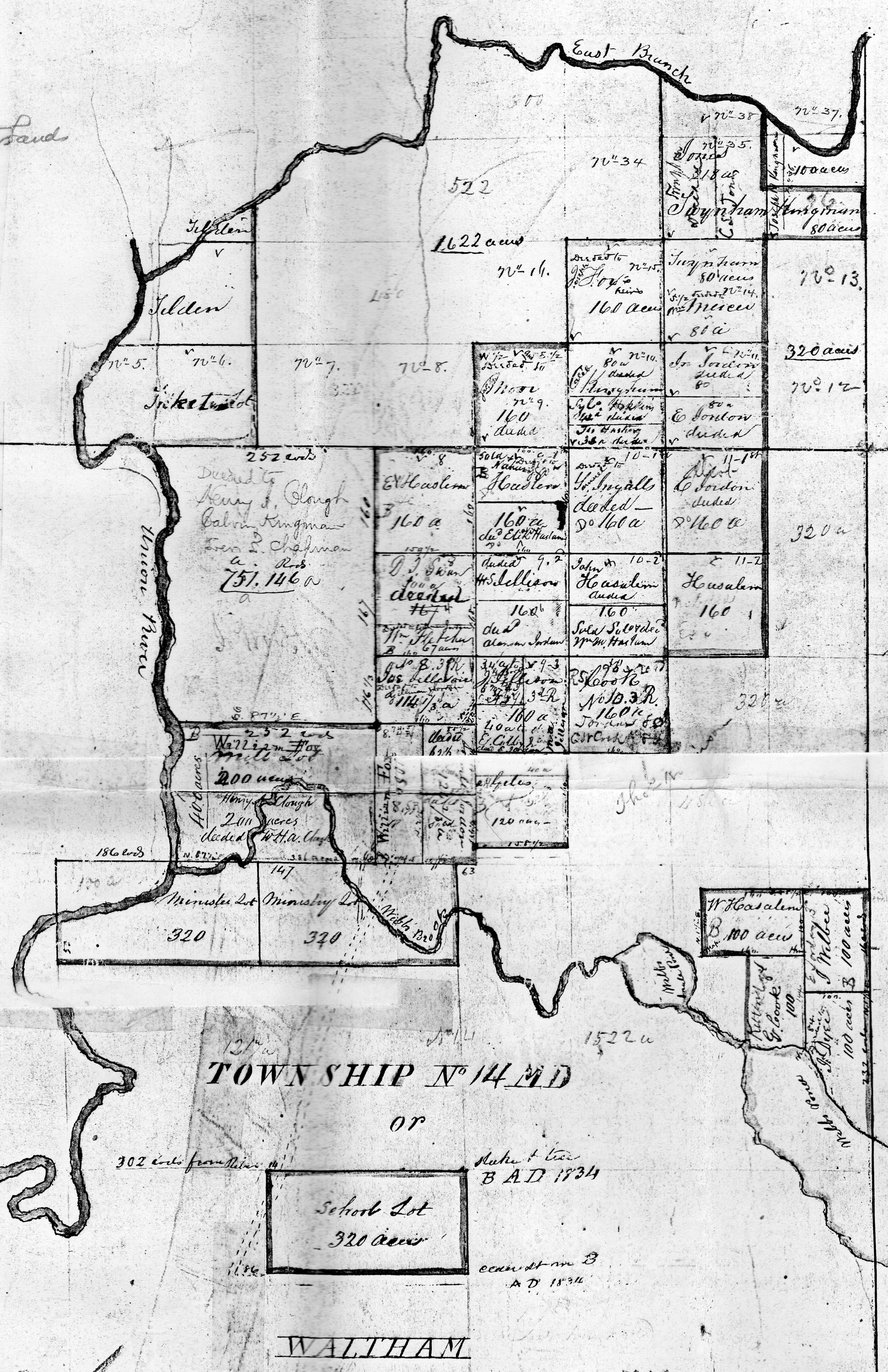
Waltham ,is a town in Hancock County, incorporated in 1833 and was was first settled in 1804 when all travel was by boat or canoe on the Union River, which flows through Graham Lake that has long frontage in the town. Name derived from Waltham Massachusetts
| Important Dates
|
| January 29, 1833 incorporated as Waltham from the T14 MD BPP.
|
| 1872. ceded land to Eastbrook
|
Villages, Locations and Settlements
Villages, Locations
and Settlements
| Settler/Namesake/Note
|
| Watham |
|
| Webbs Brook |
|
Historical Names
Pioneer Settlers
| Pioneer Settler
| Arrival Year
|
| Samuel Ingalls | 1805
|
| Eben Jordan | 1805
|
| Lebbeus Kingman | 1805
|
| Eben Kingman | 1805
|
Maps
Maps (Click an image for details)
|
|
|
|
|
|
|

|
| Waltham, Maine
|
|
Stories
Varney's Gazetteer of the state of Maine:
Waltham is situated on the eastern .side of the Union River, and is near the centre of Hancock County. Its south-west corner approaches Ellsworth, and Mariaville is the adjoining town on the north and west. The town was carved out of Mariaville, and incorporated in 1833. It was named for Waltham, Mass. Its first settlers were Samuel Ingalls, Eben Jordan, Lebbeus and Eben Kingman, who came in 1805.
The north-eastern portion of the town is thickly strewn with gigantic bowlders. Marine shells and petrified forms of plants and animals are frequently turned up by the plow. The pretty village flat at Hastings's bridge has the appearance of having been a lake bottom not many centuries since. In Cave Hill is a considerable cavern, in which three rooms have been explored. The rocks here are said to be of the same family and age as those in Orland where caves occur. The rocks there are supposed to be of the Mountain Limestone period, and are interspersed with basalt. The prevailing rock in town is said
to be slate and quartz. Waltham has a soil well fitted for potatoes and for apple orchards. The principal crop is hay and potatoes. Webb's Brook, the outlet of Webb's, Scammon's, Abrams and Molasses ponds, affords a valuable water-power. There is one mill for the
manufacture of staves and shingles.
Waltham sent 37 men into the service of the Union during the Rebellion. The Baptists have a society and a church edifice in the town. The number of public schoolhouses is four; and the school property is valued at $1,500. The valuation of estates in 1870 was $57,727. In 1880 it was $78,154. The rate of taxation in 1880 was nine mills on the dollar. The population in 1870 was 365. In the census of 1880 it was 296.
Additional Resources
- Web Sites:
- Books:
Photos
Photo Gallery (Click an image for details)
|
|
|
|
Sources
- Varney, George J. 1886. Gazetteer of the state of Maine: with numerous illustrations.
Collaboration
-
Login to edit this profile and add images.
- Private Messages:
Contact the Profile Managers privately:
Darryl Rowles and One Place Studies Project WikiTree. (Best when privacy is an issue.)
- Public Comments:
Login to post.
(Best for messages specifically directed to those editing this profile. Limit 20 per day.)


